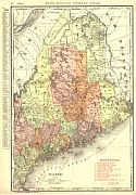
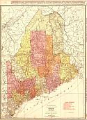
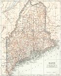
Viewing Options
Main Author:
Rand McNally and Company
Publication Info:
Chicago: Rand McNally and Co., 1911; from the Commercial Atlas of America
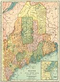
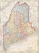
Viewing Options
Main Author:
C.S. Hammond and Company
Publication Info:
New York: C.S. Hammond and Company, 1911; from Hammond's Modern Atlas of the World
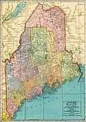
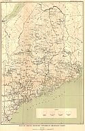
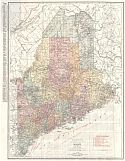
Viewing Options
Main Author:
Geographical Publishing Company
Publication Info:
Chicago: The Geographical Publishing Company, 1911
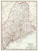
Viewing Options
Main Author:
Cram, George F.
Publication Info:
Chicago: George F. Cram, 1911; from Cram's Unrivaled Atlas of the World
Viewing Options
Main Author:
Rand McNally and Co.
Publication Info:
Chicago: Rand McNally and Co., 1912; from the Library Atlas of the World
Viewing Options
Main Author:
Rand McNally and Company
Publication Info:
Chicago: Rand McNally and Company, 1912; from The Rand McNally Imperial Atlas of the World
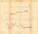
Viewing Options
Main Author:
U.S. Geological Survey
Title/Description:
Map of Maine, Showing Penobscot Drainage Basin
Publication Info:
Washington: Department of the Interior, U.S. Geological Survey, 1912; Water Supply Paper No. 279 Plate 1
Sheet 01
Sheet 02
Sheet 03
Sheet 04
Sheet 05
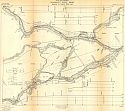
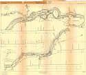
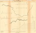
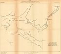
Main Author:
U.S. Geological Survey
Title/Description:
Plan and Profile of the Penobscot River, Maine - Bangor to North Twin Lake
Publication Info:
Washington: Department of the Interior, U.S. Geological Survey, 1912;
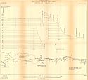
Sheet 01
Sheet 02
Sheet 03
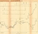
Main Author:
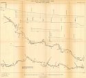
U.S. Geological Survey
Title/Description:
Plan and Profile of West Branch Penobscot River, Maine-Chesuncook Lake to Ambejejus Lake
Publication Info:
Washington: Department of the Interior, U.S. Geological Survey, 1912;
Sheet 01
Sheet 02
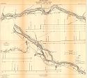
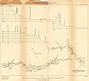
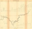
Main Author:
U.S. Geological Survey
Title/Description:
Plan and Profile of West Branch Penobscot River, Maine-Chesuncook Lake to Seboomook
Publication Info:
Washington: Department of the Interior, U.S. Geological Survey, 1912;
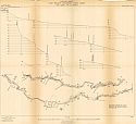
Sheet 01
Sheet 02
Sheet 03
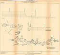
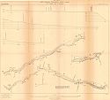
Main Author:
U.S. Geological Survey
Title/Description:
Plan and Profile of East Branch Penobscot River, Maine - First Grand Lake to Medway
Publication Info:
Washington: Department of the Interior, U.S. Geological Survey, 1912;
Viewing Options
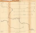
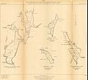
Main Author:
U.S. Geological Survey
Title/Description:
Penobscot River Drainage Basin, Maine - Chamberlain, Telos, and Webster Lakes and Round Pond
Publication Info:
Washington: Department of the Interior, U.S. Geological Survey, 1912; Water Supply Paper No. 279 Plate 17b
Viewing Options
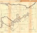
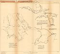
Main Author:
U.S. Geological Survey
Title/Description:
Penobscot River Drainage Basin, Maine-Baskahegan, First and Second Grand and Allagash Lakes
Publication Info:
Washington: Department of the Interior, U.S. Geological Survey, 1912; Water Supply Paper No. 279 Plate 17b
Sheet 01
Sheet 02
Sheet 03
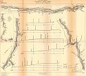
Main Author:
U.S. Geological Survey
Title/Description:
Plan and Profile of West Branch Penobscot River, Penobscot River to North Bancroft
Publication Info:
Washington: Department of the Interior, U.S. Geological Survey, 1912;
Viewing Options
Main Author:
U.S. Geological Survey
Title/Description:
Mattawamkeag and Piscataqus Drainage Basins, Maine-Schoodig, Endless, Mattawamkeag and Pleasant Lakes
Publication Info:
Washington: Department of the Interior, U.S. Geological Survey, 1912; Water Supply Paper No. 279 Plate 19
Viewing Options
Main Author:
U.S. Geological Survey
Title/Description:
Penobscot River Drainage Basin, Maine-Baskahegan, First and Second Grand and Allagash Lakes
Publication Info:
Washington: Department of the Interior, U.S. Geological Survey, 1912; Water Supply Paper No. 279 Plate 17b
Viewing Options
Main Author:
Rand McNally & Company
Publication Info:
Chicago: Rand McNally & Co., 1914
Viewing Options
Main Author:
Reynolds, Francis J.
Publication Info:
New York: P.F. Collier and Son, 1914; from The New Encyclopedic Atlas and Gazetteer of the World
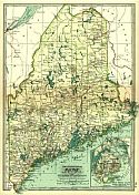
Viewing Options
Main Author:
Rand McNally & Co.
Title/Description:
New Commercial Atlas Map of Maine
Publication Info:
Chicago: Rand McNally & Co., c.1915
Viewing Options
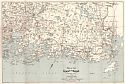
Title/Description:
Map of the Coast of Maine
Publication Info:
Boston: Walker Lith. & Pub. Co., 1915
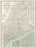
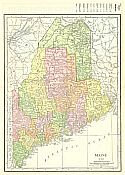
Viewing Options
Main Author:
Crocker, L.V.
Title/Description:
The Official Map of Maine
Publication Info:
Portland: The National Survey Co., 1915

