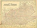
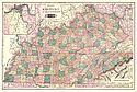
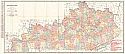
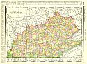
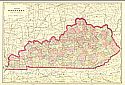
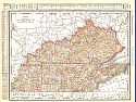
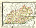
Viewing Options
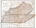
Main Author:
Mast, Crowell and Kirkpatrick
Title/Description:
Map of Kentucky and Tennessee
Publication Info:
Springfield, Ohio: Mast, Crowell, and Kirkpatrick, 1901
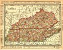
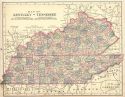
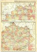
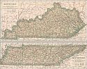
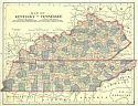
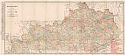
Viewing Options
Main Author:
Rand McNally and Co.
Title/Description:
Kentucky and Tennessee
Publication Info:
Chicago: Rand McNally and Co., 1901; from the Universal Atlas of the World
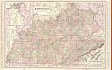
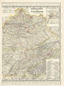
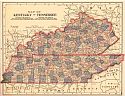
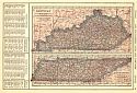
Viewing Options
Main Author:
Cram, George F.
Title/Description:
Kentucky, Tennessee
Publication Info:
Chicago: The Fort Dearborn Publishing Co., 1901; from The National Standard Family and Business Atlas of the World
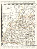
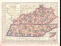
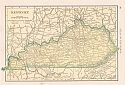
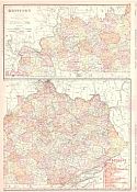
Viewing Options
Main Author:
Cram, George F.
Title/Description:
Kentucky and Tennessee, Western Half
Publication Info:
Chicago: George F. Cram, 1901; from Cram's Standard American Railway System Atlas of the World
Viewing Options
Main Author:
Tunison, Henry Cuthbert
Title/Description:
Kentucky and Tennessee
Publication Info:
New York: H.C. Tunison, 1901; from Tunison's Atlas, Encyclopædia, Gazetteer, and Portfolio of Our Universe, Globe, and Nation
Viewing Options
Main Author:
Century Company
Title/Description:
Kentucky
Publication Info:
Buffalo: The Matthews-Northrup Co., 1902; from the 1902 edition of The Century Atlas
Original Source:
From the personal collection of Dr. Robert Burckhalter
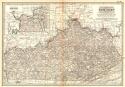
Viewing Options
Title/Description:
Map of Kentucky and Tennessee
Publication Info:
Springfield, OH: The Crowell & Kirkpatrick Company
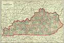
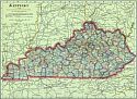
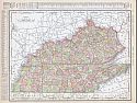
Viewing Options
Main Author:
Cram, George F.
Title/Description:
Map of Kentucky
Publication Info:
Chicago: George F. Cram, 1903
Viewing Options
Main Author:
Dodd, Mead and Company
Title/Description:
Kentucky and Tennessee
Publication Info:
New York: Dodd, Mead and Company, 1903
Viewing Options
Viewing Options
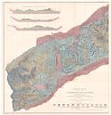
Main Author:
U.S. Geological Survey
Title/Description:
Geologic Map of a part of the Cumberland Gap Coal Field
Publication Info:
Washington: Department of the Interior, U.S. Geological Survey, 1905
Viewing Options
Title/Description:
Kentucky & Tennessee
Publication Info:
Chicago: George F. Cram, 1905
Viewing Options
Main Author:
Rand McNally and Company
Title/Description:
Kentucky
Publication Info:
Chicago: Rand McNally & Co., 1906
Viewing Options
Main Author:
Rand McNally and Company
Title/Description:
Kentucky
Publication Info:
Chicago: Rand McNally and Company from the Business Atlas and Shippers Guide
Viewing Options
Title/Description:
Kentucky and Tennessee (Eastern Half)
Publication Info:
Chicago: George F. Cram, 1906; from Grant's Bankers' and Brokers' Railway Systems Atlas
Viewing Options
Main Author:
C.S. Hammond and Company
Title/Description:
Kentucky and Tennessee
Publication Info:
St Paul: Pioneer Press, 1906; from Pioneer Press Pictorial Atlas of the World
Viewing Options
Main Author:
Rand McNally & Company
Title/Description:
Rand McNally and Co.'s New Map of Kentucky and Tennessee
Publication Info:
Chicago: Rand McNally & Co., 1907; from Rand McNally and Co.'s New Ideal Atlas
Viewing Options
Main Author:
P.F. Collier and Son
Title/Description:
Kentucky and Tennessee
Publication Info:
New York: P.F. Collier and Son, 1907; from The New Encyclopedic Atlas and Gazetteer of the World
Viewing Options
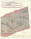
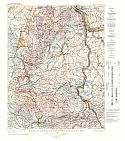
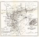
Main Author:
U.S. Geological Survey
Title/Description:
Economic and Structural Map of the Kenova Quadrangle, KY, W.VA., Ohio
Publication Info:
Washington: Department of the Interior, U.S. Geological Survey, 1907; Bulletin 349 Plate I
Viewing Options
Main Author:
U.S. Geological Survey
Title/Description:
Map of Elkhorn Coal Field, Kentucky
Publication Info:
Washington: Department of the Interior, U.S. Geological Survey, 1907; Bulletin 348 Plate 1
Viewing Options
Main Author:
Cram, George F.
Title/Description:
Kentucky
Publication Info:
Chicago: George F. Cram, 1908
Viewing Options
Title/Description:
Map of Kentucky and Tennessee
Publication Info:
New York: The Crowell Publishing Co, 1908; from The Twentieth Century Peerless Atlas
Viewing Options
Title/Description:
Kentucky and Tennessee
Publication Info:
New York: The Crowell Publishing Co., 1908; from the Peerless Atlas of the World
Viewing Options
Main Author:
Hammond, C.S.
Title/Description:
Kentucky
Publication Info:
New York: C.S. Hammond & Co. 1908; from Hammond's Handy Atlas of the World
Viewing Options
Main Author:
Rand McNally and Company
Title/Description:
Kentucky and Tennessee
Publication Info:
Chicago: Rand McNally and Company, 1908; from The New Ideal State and County Survey and Atlas
Viewing Options
Main Author:
Rand McNally
Title/Description:
Kentucky
Publication Info:
Chicago: Rand McNally & Co., 1909; with electric lines
Viewing Options
Main Author:
Patten, William and J.E. Homas
Title/Description:
Kentucky and Tennessee
Publication Info:
New York: P.F. Collier and Son, 1909; from The New Encyclopedic Atlas and Gazetteer of the World
Viewing Options
Main Author:
Cram, George F.
Title/Description:
Kentucky
Publication Info:
Chicago: George F. Cram, c.1909; from the Heart of our Country
Viewing Options
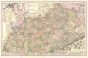
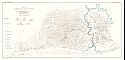
Main Author:
U.S. Geological Survey
Title/Description:
Map of the Campton Oil Field, Wolfe County, Kentucky
Publication Info:
Washington: Department of the Interior, U.S. Geological Survey, 1909; Bulletin 471 Plate I
Viewing Options
Main Author:
Rand McNally & Company
Title/Description:
Rand McNally and Co.'s New Map of Kentucky and Tennessee
Publication Info:
Chicago: Rand McNally & Co., 1910; from Rand McNally and Co.'s Atlas of the World
Viewing Options
Main Author:
Rand McNally and Company
Title/Description:
Kentucky
Publication Info:
Chicago: Rand McNally and Company, 1910; from Enlarged Business Atlas and Shippers Guide
Viewing Options
Main Author:
Rand McNally and Company
Title/Description:
Kentucky, Tennessee
Publication Info:
Chicago: Rand McNally and Company, 1910; from New Ideal State and County Survey