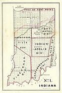
Historical Maps of Other Southeastern States

Selected Indiana Out-of-Print Quadrangles

Next Page

  Main Author:   Meigs, J.
  Title/Description:   Boundaries of the Reservation for Wabash Saline
  Publication Info:   Washington, D.C.: General Land Office, c.1835, Edition of 1816 Map
  Date:   1816
  Scale:   1:125,000
  Original Source:   Courtesy of Murray Hudson, Halls, Tennessee
Viewing options:


  Main Author:   Lucas, Fielding, Jr.
  Title/Description:   Geographical, Statistical, and Historical Map of Indiana
  Publication Info:   Philadelphia: Carey & Lea, 1822
  Date:   1822
  Scale:   1:1,774,000
  Original Source:   Courtesy of Murray Hudson, Halls, Tennessee
Viewing options:


  Main Author:   General Land Office
  Title/Description:   Part of the State of Indiana From Actual Survey on File in the General Land Office, January 13th 1831
  Publication Info:   Washington, D.C.: General Land Office, 1831
  Date:   1831
  Scale:   1:760,000
  Original Source:   Courtesy of Murray Hudson, Halls, Tennessee
Viewing options:


  Main Author:   General Land Office
  Title/Description:   Part of the State of Indiana
  Publication Info:   Washington, D.C.: General Land Office, 1831; Area from Indianapolis North to Lake Michigan; from Actual Survey on File in the GLO, January 13th, 1831
  Date:   1831
  Scale:   1:1,521,000
  Original Source:   Courtesy of Murray Hudson, Halls, Tennessee
Viewing options:


  Main Author:    
  Title/Description:   No. 1 Index to Record Field Notes Indiana
  Publication Info:   Philadelphia: P.S. Durall's Steam Lithograph Press, c.1835
  Date:   1835
  Scale:   1:1,140,000
  Original Source:   Courtesy of Murray Hudson, Halls, Tennessee
Viewing options:


  Main Author:   Bradford, T.G.
  Title/Description:   Indiana & Ohio
  Publication Info:   Boston: T.G. Bradford, 1835
  Date:   1835
  Scale:   1:2,560,000
  Original Source:   Courtesy of Murray Hudson, Halls, Tennessee
Viewing options:


  Main Author:   Young, J.H.
  Title/Description:   The Tourist's Pocket Map of the State of Indiana
  Publication Info:   Philadelphia: S. Augustus Mitchell, 1837; Exhibiting its Internal Improvements, Road Distances, ect.
  Date:   1837
  Scale:   1:1,267,000
  Original Source:   Courtesy of Murray Hudson, Halls, Tennessee
Viewing options:


  Main Author:   
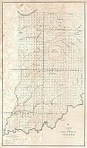
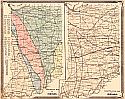
Stone, W.J., Surveyor General, Indiana
  Title/Description:   No. 1 Indiana
  Publication Info:   Washington, D.C.: General Land Office, 1841; for 26th Congress, 2nd Session
  Date:   1841
  Scale:   1:2,408,000
  Original Source:   Courtesy of Murray Hudson, Halls, Tennessee
Viewing options:


  Main Author:   [General Land Office]
  Title/Description:   G-A Sketch of the Public Surveys in Indiana
  Publication Info:   General Land Office, 1845
  Date:   1845
  Scale:   1:1,140,000
  Original Source:   Courtesy of Murray Hudson, Halls, Tennessee
Viewing options:


  Main Author:   Colton, J.H.
  Title/Description:   Colton's Indiana
  Publication Info:   New York: J.H. Colton, 1856
  Date:   1856
  Scale:   1:1,267,000
  Original Source:   Courtesy of Murray Hudson, Halls, Tennessee
Viewing options:


  Main Author:   Colton, Joseph H.
  Title/Description:   Indiana
  Publication Info:   New York: J.H. Colton, c.1856
  Date:   1856
  Scale:   1:1,331,000
  Original Source:   Courtesy of Murray Hudson, Halls, Tennessee
Viewing options:


  Main Author:   Johnson, Alvin J.
  Title/Description:   Johnson's Indiana
  Publication Info:   New York: A.J. Johnson, c.1864
  Date:   1864
  Scale:   1:760,000
  Original Source:   Courtesy of Murray Hudson, Halls, Tennessee
Viewing options:


  Main Author:   Johnson, Alvin J.
  Title/Description:   Johnson's Indiana
  Publication Info:   New York: A.J. Johnson, c.1864
  Date:   1864
  Scale:   1:760,000
  Original Source:   Courtesy of Murray Hudson, Halls, Tennessee
Viewing options:


  Main Author:   Johnson, Alvin J.
  Title/Description:   Johnson's Indiana
  Publication Info:   New York: A.J. Johnson, c.1870
  Date:   1870
  Scale:   1:887,000
  Original Source:   Courtesy of Murray Hudson, Halls, Tennessee
Viewing options:


  Main Author:   Department of Geology and Natural History of Indiana
  Title/Description:   Map of Daviess and Martin Counties, Indiana
  Publication Info:   Department of Geology and Natural History, 1870; drawn by G.M. Levette for the Department's 2nd Annual Report
  Date:   1870
  Scale:   1:90,000
  Original Source:   University of Alabama Map Library
Viewing options:


  Main Author:   Department of Geology and Natural History of Indiana
  Title/Description:   Map of Sullivan County, Indiana
  Publication Info:   Department of Geology and Natural History, 1870; drawn by G.M. Levette for the Department's 2nd Annual Report
  Date:   1870
  Scale:   1:90,000
  Original Source:   University of Alabama Map Library
Viewing options:


  Main Author:   Colton, G.W. and C.B.
  Title/Description:   Colton's Indiana
  Publication Info:   New York: G.W. & C.B. Colton, c.1873
  Date:   1873
  Scale:   1:1,331,000
  Original Source:   Courtesy of Murray Hudson, Halls, Tennessee
Viewing options:


  Main Author:   Department of Geology and Natural History of Indiana
  Title/Description:   Map of Lawrence County, Indiana
  Publication Info:   Department of Geology and Natural History, 1873; report by E.T. Cox for the Department's 5th Annual Report
  Date:   1873
  Scale:   1:125,000
  Original Source:   University of Alabama Map Library
Viewing options:


  Main Author:   Department of Geology and Natural History of Indiana
  Title/Description:   Map of Warren County, Indiana
  Publication Info:   Department of Geology and Natural History, 1873; report by E.T. Cox for the Department's 5th Annual Report
  Date:   1873
  Scale:   1:125,000
  Original Source:   University of Alabama Map Library
Viewing options:


  Main Author:   Department of Geology and Natural History of Indiana
  Title/Description:   Map of Clarke and Floyd Counties, Indiana
  Publication Info:   Department of Geology and Natural History, 1873; report by E.T. Cox for the Department's 5th Annual Report
  Date:   1873
  Scale:   1:125,000
  Original Source:   University of Alabama Map Library
Viewing options:


  Main Author:   Department of Geology and Natural History of Indiana
  Title/Description:   Map of Knox and Gibson Counties, Indiana
  Publication Info:   Department of Geology and Natural History, 1873; report by John Collett for the Department's 5th Annual Report
  Date:   1873
  Scale:   1:125,000
  Original Source:   University of Alabama Map Library
Viewing options:


  Main Author:   Department of Geology and Natural History of Indiana
  Title/Description:   Map of Scott County, Indiana
  Publication Info:   Department of Geology and Natural History, 1874; report by W.W. Borden for the Department's 6th Annual Report
  Date:   1874
  Scale:   1:125,000
  Original Source:   University of Alabama Map Library
Viewing options:


  Main Author:   Department of Geology and Natural History of Indiana
  Title/Description:   Map of Jefferson County, Indiana
  Publication Info:   Department of Geology and Natural History, 1874; report by W.W. Borden for the Department's 6th Annual Report
  Date:   1874
  Scale:   1:125,000
  Original Source:   University of Alabama Map Library
Viewing options:


  Main Author:   Department of Geology and Natural History of Indiana
  Title/Description:   Map of Jackson, Indiana
  Publication Info:   Department of Geology and Natural History, 1874; prepared for the Department's 6th Annual Report
  Date:   1874
  Scale:   1:125,000
  Original Source:   University of Alabama Map Library
Viewing options:


  Main Author:   Department of Geology and Natural History of Indiana
  Title/Description:   Map of Brown County, Indiana
  Publication Info:   Department of Geology and Natural History, 1874; report by John Collett for the Department's 6th Annual Report
  Date:   1874
  Scale:   1:125,000
  Original Source:   University of Alabama Map Library
Viewing options:


  Main Author:   Department of Geology and Natural History of Indiana
  Title/Description:   Map of Owen County, Indiana
  Publication Info:   Department of Geology and Natural History, 1875; report by John Collett for the Department's 7th Annual Report
  Date:   1875
  Scale:   1:125,000
  Original Source:   University of Alabama Map Library
Viewing options:


  Main Author:   Department of Geology and Natural History of Indiana
  Title/Description:   Map of Vigo County, Indiana
  Publication Info:   Department of Geology and Natural History, 1875; report by E.T. Cox for the Department's 7th Annual Report
  Date:   1875
  Scale:   1:125,000
  Original Source:   University of Alabama Map Library
Viewing options:


  Main Author:   Department of Geology and Natural History of Indiana
  Title/Description:   Map of Montgomery County, Indiana
  Publication Info:   Department of Geology and Natural History, 1875; report by John Collett for the Department's 7th Annual Report
  Date:   1875
  Scale:   1:125,000
  Original Source:   University of Alabama Map Library
Viewing options:


  Main Author:   Department of Geology and Natural History of Indiana
  Title/Description:   Map of Vanderburgh County, Indiana
  Publication Info:   Department of Geology and Natural History, 1875; report by John Collett for the Department's 7th Annual Report
  Date:   1875
  Scale:   1:125,000
  Original Source:   University of Alabama Map Library
Viewing options:


  Main Author:   A. von Steinwher, A.M.
  Title/Description:   Map of Indiana
  Publication Info:   Buffalo: H. Chandler, (c. 1876)
  Date:   1876
  Scale:   1:1,591,000
  Original Source:   Geological Survey of Alabama
Viewing options:


  Main Author:   Gray, Frank A.
  Title/Description:   Indiana
  Publication Info:   Philadelphia: O.W. Gray & Son, c.1876
  Date:   1876
  Scale:   1:760,000
  Original Source:   Courtesy of Murray Hudson, Halls, Tennessee
Viewing options:


  Main Author:   Baskin, Forester, & Co.
  Title/Description:   Geological Map of Indiana - Climatological Map of Indiana
  Publication Info:   Chicago: Baskin, Forester, & Co., 1876; from their Illustrated Atlas of the State of Indiana
  Date:   1876
  Scale:   1:1,584,000
  Original Source:   Courtesy of Murray Hudson, Halls, Tennessee
Viewing options:


  Main Author:   Baskin, Forester, & Co.
  Title/Description:   Congressional Districts - Judicial Districts
  Publication Info:   Chicago: Baskin, Forester, & Co., 1876; from their Illustrated Atlas of the State of Indiana
  Date:   1876
  Scale:   1:1,584,000
  Original Source:   Courtesy of Murray Hudson, Halls, Tennessee
Viewing options:


  Main Author:   Durant, S.W.
  Title/Description:   Map of Marion County
  Publication Info:   Chicago: Baskin, Foster & Co., 1876; from the Illustrated Atlas of the State of Indiana
  Date:   1876
  Scale:   1:40,000
  Original Source:   Courtesy of Murray Hudson, Halls, Tennessee
Viewing options:


  Main Author:   Durant, S.W.
  Title/Description:   North-Eastern Part of Indianapolis [and] North Indianapolis [and] Irvington
  Publication Info:   Chicago: Baskin, Foster & Co., 1876; from the Illustrated Atlas of the State of Indiana
  Date:   1876
  Scale:   various scales
  Original Source:   Courtesy of Murray Hudson, Halls, Tennessee
Viewing options:


  Main Author:   Durant, S.W.
  Title/Description:   Plan of Indianapolis
  Publication Info:   Chicago: Baskin, Foster & Co., 1876; from the Illustrated Atlas of the State of Indiana
  Date:   1876
  Scale:   1:16,500
  Original Source:   Courtesy of Murray Hudson, Halls, Tennessee
Viewing options:


  Main Author:    
  Title/Description:   New Sectional and Township Map of Indiana
  Publication Info:   Chicago: Baskin, Forster & Co., 1876; from the Illustrated Historical Atlas of the State of Indiana
  Date:   1876
  Scale:   1:760,000
  Original Source:   Courtesy of Murray Hudson, Halls, Tennessee
Viewing options:


  Main Author:   Gray, Frank A.
  Title/Description:   Indianapolis - Louisville
  Publication Info:   Philadelphia: O.W. Gray & Son, 1877; from an early Hardesty Historical Atlas of the World
  Date:   1877
  Scale:   1:21,600
  Original Source:   Courtesy of Murray Hudson, Halls, Tennessee
Viewing options:


  Main Author:   Gray, Frank A.
  Title/Description:   Indiana
  Publication Info:   Philadelphia: O.W. Gray; from The Nationa Atlas
  Date:   1880
  Scale:   1:760,000
  Original Source:   Courtesy of Murray Hudson, Halls, Tennessee
Viewing options:
 

Next Page