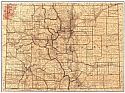
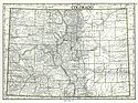
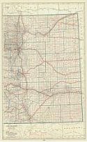
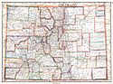
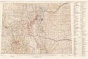
Viewing Options
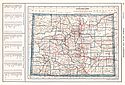
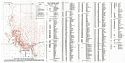
Main Author:
Rand McNally and Company
Title/Description:
Colorado
Publication Info:
Chicago: Rand McNally and Company, 1921; from the Commercial Atlas of America
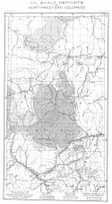
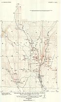
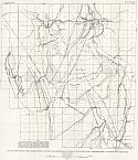
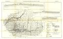
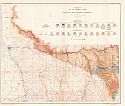
Viewing Options
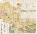
Main Author:
Colorado Geological Survey
Title/Description:
Oil Shale Deposits of Northwestern Colorado
Publication Info:
Boulder: Colorado Geological Survey, 1921; Bulletin 25, Plate 1
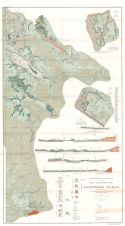
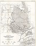
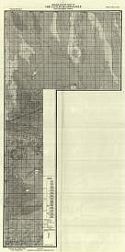
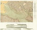
Viewing Options
Main Author:
Colorado Geological Survey
Title/Description:
Reconnaissance Geologic Map of the Main Carnotite Area of Southwestern Colorado
Publication Info:
Boulder: Colorado Geological Survey, 1921; Bulletin 16
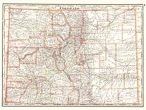
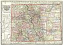
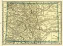
Viewing Options
Main Author:
Cram, George F.
Title/Description:
Colorado
Publication Info:
Chicago: George F. Cram Company, 1921; from Cram's Unrivaled Atlas of the World
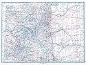
Viewing Options
Main Author:
National Map Company
Title/Description:
Colorado
Publication Info:
Indianapolis: National Map Company, 1921; from Auto Trails and Commercial Survey of the United States
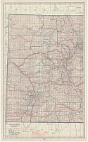
Viewing Options
Main Author:
National Map Company
Title/Description:
Colorado
Publication Info:
Indianapolis: National Map Company, 1921; from Auto Trails and Commercial Survey of the United States
Viewing Options
Main Author:
The Geographical Publishing Co.
Title/Description:
Colorado
Publication Info:
Chicago: The Geographical Publishing Co., 1922; from New International Atlas of the World
Viewing Options
Main Author:
C.S. Hammond and Company
Title/Description:
Colorado (Western Part)
Publication Info:
New York: C.S. Hammond and Company, 1922; from The New World Looseleaf Atlas
Viewing Options
Main Author:
C.S. Hammond and Company
Title/Description:
Colorado (Eastern Part)
Publication Info:
New York: C.S. Hammond and Company, 1922; from The New World Looseleaf Atlas
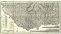
Viewing Options
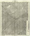
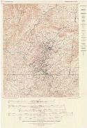
Main Author:
U.S. Geological Survey
Title/Description:
Topographic Map of Creede and Vicinity, Colorado Showing Principal Mineral Faults and Veins
Publication Info:
Washington: Department of the Interior, U.S. Geological Survey, 1922; Bulletin 718 Plate I
Viewing Options
Main Author:
U.S. Geological Survey
Title/Description:
Map of Part of Northwestern Colorado Showing Areas of Green River Formation
Publication Info:
Washington: Department of the Interior, U.S. Geological Survey, 1922; Bulletin 729 Plate 8
Viewing Options
Main Author:
U.S. Geological Survey
Title/Description:
Geologic Map of Creede and Vicinity
Publication Info:
Washington: Department of the Interior, U.S. Geological Survey, 1922; Bulletin 718 Plate II
Viewing Options
Main Author:
Cram, George F.
Title/Description:
Colorado
Publication Info:
Chicago: George F. Cram Company, 1923; from Cram's Unrivaled Atlas of the World
Viewing Options
Main Author:
U.S. Geological Survey
Title/Description:
Map of Twentymile Park District, Routt County, Colorado, Showing outcrops of coal, principal sandstone beds and Geologic Structure
Publication Info:
Washington: Department of the Interior, U.S. Geological Survey, 1923; Bulletin 748 Plate 1
Viewing Options
Main Author:
Funk and Wagnalls Company
Title/Description:
Colorado
Publication Info:
New York: Funk and Wagnalls Company, 1923; from Atlas of the World and Gazetteer
Viewing Options
Title/Description:
Geological Map of Part of the Catlin Quadrangle and Adjacent Areas
Publication Info:
Boulder: Colorado Geological Survey, 1924; from Bulletin No. 27
Viewing Options
Title/Description:
Geologic Map of the La Junta Area
Publication Info:
Boulder: Colorado Geological Survey, 1924; from Bulletin No. 27
Viewing Options
Main Author:
Crawford, R.C.
Title/Description:
Map of the McElmo Anticline, Montezuma County, Colorado
Publication Info:
Boulder: Colorado Geological Survey, 1924; from bulletin No. 24

Viewing Options
Main Author:
Colorado Geological Survey
Title/Description:
Geologic Map of Parts of Las Animas Otero and Bent Counties
Publication Info:
Boulder: Colorado Geological Survey, 1924; from Bulletin No. 27
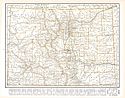
Viewing Options
Main Author:
U.S. Geological Survey
Title/Description:
Map of Colorado Showing Location of Mining Districts, Transmission Lines and Water-Power Plants
Publication Info:
Washington: U.S. Deparment of the Interior, Geological Survey
Viewing Options
Main Author:
U.S. Geological Survey
Title/Description:
Geologic Map and Structure Sections of the Axial and Monument Butte Quadrangles, Colorado
Publication Info:
Washington: Department of the Interior, U.S. Geological Survey, 1924; Bulletin 757 Plate 19
Viewing Options
Main Author:
U.S. Geological Survey
Title/Description:
Geologic Map of Part of Moffat County Colorado and Southern Sweetwater County, Wyoming
Publication Info:
Washington: Department of the Interior, U.S. Geological Survey, 1924; Bulletin 757 Plate 35
Viewing Options
Main Author:
Reynolds, Francis J.
Title/Description:
Colorado
Publication Info:
New York: P.F. Collier and Son Company, 1924; from The New World Atlas and Gazetteer
Viewing Options
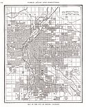
Main Author:
Reynolds, Francis J.
Title/Description:
Denver
Publication Info:
New York: P.F. Collier and Son Company, 1924; from The New World Atlas and Gazetteer
Viewing Options
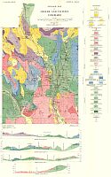
Main Author:
Colorado Geological Survey
Title/Description:
Geologic Map of Portions of Delta and Mesa Counties, Colorado
Publication Info:
Boulder: Colorado Geological Survey, 1925; from bulletin No. 28
Viewing Options
Title/Description:
Mining Claims of the Red Cliff District, Colorado
Publication Info:
Boulder: Colorado Geological Survey, 1925; from Bulletin No. 30
Viewing Options
Main Author:
U.S. Geological Survey
Title/Description:
Geologic Map and Sections of the Ducktown Mining District, Colorado
Publication Info:
Washington: U.S. Deparment of the Interior, Geological Survey
Viewing Options
Main Author:
U.S. Geological Survey
Title/Description:
Geologic Map Showing the Pre-Cambrian Rocks of the Gunnison River Region, Colorado
Publication Info:
Washington: Department of the Interior, U.S. Geological Survey, 1925; Bulletin 777 Plate 1
Viewing Options
Main Author:
Rand McNally and Company
Title/Description:
Colorado
Publication Info:
Chicago: Rand McNally and Company, 1925; from Premier Atlas of the World

