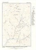
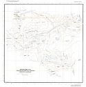
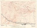
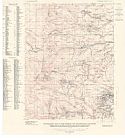
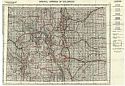
Viewing Options
Main Author:
Colorado State Geological Survey
Title/Description:
Topographic Map of the Gold Brick Mining District, Colorado
Publication Info:
Colorado Geological Survey Bulletin 10, Plate 1, 1916
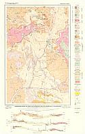
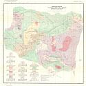
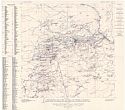
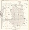
Viewing Options
Main Author:
Colorado State Geological Survey
Title/Description:
Geologic Map of the Gold Brick Mining District, Colorado
Publication Info:
Colorado Geological Survey Bulletin 10, Plate 2, 1916
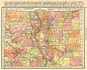
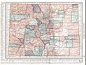
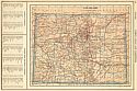
Viewing Options
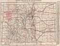
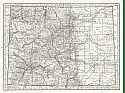
Main Author:
Rand McNally and Company
Title/Description:
Colorado
Publication Info:
Chicago: Rand McNally and Co., 1916; from the Ideal Atlas of the World
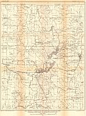
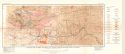
Viewing Options
Main Author:
U.S. Geological Survey
Title/Description:
Map showing Contructed and Proposed Diversion from Colorado River Basin to Mississippi River Basin
Publication Info:
Washington: Department of the Interior, U.S. Geological Survey, 1916; Water Supply Paper No. 395 Plate 15
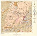
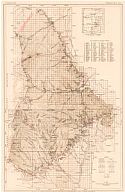
Viewing Options
Main Author:
Colorado State Geological Survey
Title/Description:
Topographic Map of the Platoro-Summitvillei Mining District, Colorado
Publication Info:
Colorado State Geological Survey, Bulletin 13, Plate 1, 1917
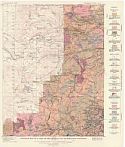
Viewing Options
Main Author:
Colorado State Geological Survey
Title/Description:
Geologic Map of the Platoro-Summitvillei Mining District, Colorado
Publication Info:
Colorado State Geological Survey, Bulletin 13, Plate 2, 1917
Viewing Options
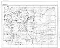
Main Author:
U.S. Geological Survey
Title/Description:
Geologic Map of the Idaho Springs Quadrangle, Colorado
Publication Info:
Washington: U.S. Deparment of the Interior, Geological Survey
Viewing Options
Main Author:
U.S. Geological Survey
Title/Description:
Topographic Map of the Idaho Springs Quadrangle, Colorado
Publication Info:
Washington: U.S. Deparment of the Interior, Geological Survey
Viewing Options
Main Author:
U.S. Geological Survey
Title/Description:
Claim Map of the Idaho Springs Quadrangle, Colorado
Publication Info:
Washington: U.S. Deparment of the Interior, Geological Survey
Viewing Options
Main Author:
U.S. Geological Survey
Title/Description:
Topographic Map of the Central City District, Colorado
Publication Info:
Washington: U.S. Deparment of the Interior, Geological Survey
Viewing Options
Main Author:
U.S. Geological Survey
Title/Description:
Geologic Map of the Central City District, Colorado
Publication Info:
Washington: U.S. Deparment of the Interior, Geological Survey
Viewing Options
Main Author:
U.S. Geological Survey
Title/Description:
Geological Map of a part of the Central City District, Colorado
Publication Info:
Washington: U.S. Deparment of the Interior, Geological Survey
Viewing Options
Main Author:
U.S. Geological Survey
Title/Description:
Topographic Map of the Central City District showing location of mines outside the areas of the larger scale maps, position, and classification of veins, and position of larger tunnels
Publication Info:
Washington: U.S. Deparment of the Interior, Geological Survey
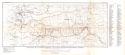
Viewing Options
Main Author:
U.S. Geological Survey
Title/Description:
Map of the Northwestern Colorado and Northeastern Utah Showing Areas of Green River Formation
Publication Info:
Washington: Department of the Interior, U.S. Geological Survey, 1917; Bulletin 641 Plate 18
Viewing Options
Main Author:
U.S. Geological Survey
Title/Description:
Map of the Raton Mesa Region, Colorado and New Mexico
Publication Info:
Washington: U.S. Deparment of the Interior, Geological Survey
Viewing Options
Main Author:
C.S. Hammond and Company
Title/Description:
Colorado
Publication Info:
New York: C.S. Hammond and Company, 1918; from Hammonds Pictorial Atlas of the World
Viewing Options
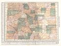
Main Author:
George, R.D.
Title/Description:
Clason's Guide Map of the State of Colorado
Publication Info:
Denver: The Clason Map Co., c.1920
Viewing Options
Viewing Options
Main Author:
Colorado Geological Survey
Title/Description:
Mineral Deposits of the Western Slope
Publication Info:
Boulder: Colorado Geological Survey, 1920; from Bulletin 22
Viewing Options
Title/Description:
Mineral Springs of Colorado
Publication Info:
Boulder: Colorado Geological Survey, 1920; from Bulletin No. 11
Viewing Options
Main Author:
Reynolds, Francis J.
Title/Description:
Colorado
Publication Info:
New York: P.F. Collier and Son Company, 1920; from The New World Atlas and Gazetteer
Viewing Options
Main Author:
Cram, George F.
Title/Description:
Colorado
Publication Info:
Chicago: James R. Gray and Company, 1920; from Cram's Unrivaled Atlas of the World
Viewing Options
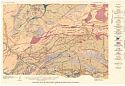
Main Author:
Colorado Geological Survey
Title/Description:
Geologic Map of Ward, Sugarloaf and Near-by Regions, Boulder County, Colorado
Publication Info:
Boulder: Colorado Geological Survey, c. 1920; Bulletin 21 Plate 2
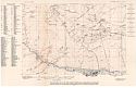
Viewing Options
Main Author:
Colorado Geological Survey
Title/Description:
Topographic Map of Ward, Sugarloaf and Near-by Regions, Boulder County, Colorado
Publication Info:
Boulder: Colorado Geological Survey, c. 1920; Bulletin 21 Plate 1
Viewing Options
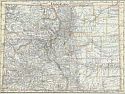
Main Author:
C.S. Hammond and Company
Title/Description:
Colorado
Publication Info:
New York: C.S. Hammond and Company, 1920; from The New Reference Atlas of the World
Original Source:
Courtesy of Shawn Carter
Viewing Options
Main Author:
Leslie-Judge Company
Title/Description:
Colorado
Publication Info:
New York: Leslie-Judge Company, 1920; from Leslie's New World Atlas

