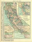
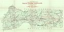
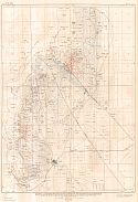
Historical Maps of Other Southeastern States

1901 - 1910
Before 1875
1875-1890
1891-1900
1901-1910
1911-1925
After 1925

Previous Page
Next Page

  Main Author:   U.S. Geological Survey
  Title/Description:   Southern California, Sheet 1
  Publication Info:   Washington: U.S. Department of the Interior, U.S. Geological Survey, 1901
  Date:   1901
  Scale:   1:250,000
  Original Source:   University of Alabama Map Library
Viewing options:


  Main Author:   U.S. Geological Survey
  Title/Description:   Grass Valley Special Map, Nevada County, California
  Publication Info:   Washington: U.S. Department of the Interior, U.S. Geological Survey, 1901
  Date:   1901
  Scale:   1:14,400
  Original Source:   University of Alabama Map Library
Viewing options:


  Main Author:   Rand McNally and Company
  Title/Description:   Rand McNally & Co's California
  Publication Info:   Chicago: Rand McNally & Co.,1901
  Date:   1901
  Scale:   1:1,964,000
  Original Source:   Courtesy of Murray Hudson, Halls, Tennessee
Viewing options:


  Main Author:   U.S. Surveyor General's Office
  Title/Description:   Plot of the Exterior Boundaries of Sequoia National Park, California
  Publication Info:   Washington: The Norris Peters Co., 1901
  Date:   1901
  Scale:   1:96,000
  Original Source:   Courtesy of Murray Hudson, Halls, Tennessee
Viewing options:


  Main Author:   Rand McNally and Company
  Title/Description:   California
  Publication Info:   Chicago: Rand McNally and Company, 1901; from The Enlarged Business Atlas and Shippers Guide
  Date:   1901
  Scale:   1:1,964,160
  Original Source:   Courtesy of Murray Hudson, Halls, Tennessee
Viewing options:


  Main Author:   Rand McNally and Company
  Title/Description:   California
  Publication Info:   Chicago: Rand McNally and Company, 1901; from The Universal Atlas of the World
  Date:   1901
  Scale:   1:4,118,400
  Original Source:   Courtesy of Murray Hudson, Halls, Tennessee
Viewing options:


  Main Author:   Mast, Crowell and Kirkpatrick
  Title/Description:   Map of California and Nevada
  Publication Info:   Chicago: Benedict and Company, 1902
  Date:   1902
  Scale:   1:2,851,000
  Original Source:   University of Alabama Map Library
Viewing options:


  Main Author:   The Century Company
  Title/Description:   California-Northern Part
  Publication Info:   Buffalo: The Matthew-Northrup Company, 1902
  Date:   1902
  Scale:   1:2,281,000
  Original Source:   From the personal collection of Dr. Robert Burckhalter
Viewing options:


  Main Author:   The Century Company
  Title/Description:   California-Southern Part
  Publication Info:   Buffalo: The Matthew-Northrup Company, 1902
  Date:   1902
  Scale:   1:2,281,000
  Original Source:   From the personal collection of Dr. Robert Burckhalter
Viewing options:


  Main Author:   U.S. Geological Survey
  Title/Description:   Truckee Quadrangle Showing land classification and density of standing timber
  Publication Info:   Washington: Department of the Interior, U.S. Geological Survey, 1902; from Professional Paper No. 8 Plate I
  Date:   1902
  Scale:   1:125,000
  Original Source:   Geological Survey of Alabama
Viewing options:


  Main Author:   U.S. Geological Survey
  Title/Description:   Colfax Quadrangle Showing land classification and density of standing timber
  Publication Info:   Washington: Department of the Interior, U.S. Geological Survey, 1902; from Professional Paper No. 8 Plate II
  Date:   1902
  Scale:   1:125,000
  Original Source:   Geological Survey of Alabama
Viewing options:


  Main Author:   U.S. Geological Survey
  Title/Description:   Smartsville Quadrangle Showing land classification and density of standing timber
  Publication Info:   Washington: Department of the Interior, U.S. Geological Survey, 1902; from Professional Paper No. 8 Plate III
  Date:   1902
  Scale:   1:125,000
  Original Source:   Geological Survey of Alabama
Viewing options:


  Main Author:   U.S. Geological Survey
  Title/Description:   Sierraville Quadrangle Showing land classification and density of standing timber
  Publication Info:   Washington: Department of the Interior, U.S. Geological Survey, 1902; from Professional Paper No. 8 Plate IV
  Date:   1902
  Scale:   1:125,000
  Original Source:   Geological Survey of Alabama
Viewing options:


  Main Author:   U.S. Geological Survey
  Title/Description:   Downieville Quadrangle Showing land classification and density of standing timber
  Publication Info:   Washington: Department of the Interior, U.S. Geological Survey, 1902; from Professional Paper No. 8 Plate V
  Date:   1902
  Scale:   1:125,000
  Original Source:   Geological Survey of Alabama
Viewing options:


  Main Author:   U.S. Geological Survey
  Title/Description:   Bidwell Bar Quadrangle Showing land classification and density of standing timber
  Publication Info:   Washington: Department of the Interior, U.S. Geological Survey, 1902; from Professional Paper No. 8 Plate VI
  Date:   1902
  Scale:   1:125,000
  Original Source:   Geological Survey of Alabama
Viewing options:


  Main Author:   Matthews, James Newton
  Title/Description:   California and Nevada
  Publication Info:   Buffalo: J.N. Matthews Co., 1903
  Date:   1903
  Scale:   1:2,978,000
  Original Source:   Courtesy of Murray Hudson, Halls, Tennessee
Viewing options:


  Main Author:   Southern Pacific Railroad
  Title/Description:   Map of California Illustrating its Climatology - Comparative Area - Rail Lines
  Publication Info:   San Francisco: Southern Pacific Railroad, 1903
  Date:   1903
  Scale:   1:1,901,000
  Original Source:   Courtesy of Murray Hudson, Halls, Tennessee
Viewing options:


  Main Author:   Cram, George F.
  Title/Description:   Map of California
  Publication Info:   Chicago: George F. Cram, 1903; from The Modern Atlas
  Date:   1903
  Scale:   1:2,407,680
  Original Source:   Courtesy of Murray Hudson, Halls, Tennessee
Viewing options:


  Main Author:   California State Mining Bureau
  Title/Description:   Map of Amador County, California
  Publication Info:   San Francisco: California State Mining Bureau, 1903
  Date:   1903
  Scale:   1:95,040
  Original Source:   Geological Survey of Alabama
Viewing options:


  Main Author:   California State Mining Bureau
  Title/Description:   Map of Tuolumne County, California
  Publication Info:   San Francisco: California State Mining Bureau, 1903
  Date:   1903
  Scale:   1:158,400
  Original Source:   Geological Survey of Alabama
Viewing options:


  Main Author:   U.S. Geological Survey
  Title/Description:   Southern California, Sheet 2
  Publication Info:   Washington: U.S. Department of the Interior, U.S. Geological Survey, 1904
  Date:   1904
  Scale:   1:250,000
  Original Source:   University of Alabama Map Library
Viewing options:


  Main Author:   California State Mining Bureau
  Title/Description:   Relief and Mineral Map of California
  Publication Info:   San Francisco: California State Mining Bureau, 1904
  Date:   1904
  Scale:   1:2,091,000
  Original Source:   Geological Survey of Alabama
Viewing options:


  Main Author:   Miller, J. Martin
  Title/Description:   California
  Publication Info:   unknown, 1904; from The Twentieth Century Atlas and Illustrated World
  Date:   1904
  Scale:   1:3,294,720
  Original Source:   Courtesy of Murray Hudson, Halls, Tennessee
Viewing options:


  Main Author:   California State Mining Bureau
  Title/Description:   Map of Butte County, California
  Publication Info:   San Francisco: California State Mining Bureau, 1904
  Date:   1904
  Scale:   1:125,000
  Original Source:   Geological Survey of Alabama
Viewing options:


  Main Author:   Rand McNally & Company
  Title/Description:   Rand McNally & Company's California
  Publication Info:   Chicago: Rand McNally & Co., 1905
  Date:   1905
  Scale:   1:1,014,000
  Original Source:   Courtesy of Murray Hudson, Halls, Tennessee
Viewing options:


  Main Author:   California State Mining Bureau
  Title/Description:   Map of the Southern Portion of California showing the Saline Deposits and the Desert Section of the State
  Publication Info:   San Francisco: California State Mining Bureau, 1905
  Date:   1905
  Scale:   1:120,000
  Original Source:   Geological Survey of Alabama
Viewing options:


  Main Author:   California State Mining Bureau
  Title/Description:   Map of Yuba County, California
  Publication Info:   San Francisco: California State Mining Bureau, 1905
  Date:   1905
  Scale:   1:95,040
  Original Source:   Geological Survey of Alabama
Viewing options:


  Main Author:   Rand McNally and Company.
  Title/Description:   California
  Publication Info:   Chicago: Rand McNally and Company, 1905; from The Unrivaled Atlas of the World
  Date:   1905
  Scale:   1:4,118,400
  Original Source:   Courtesy of Murray Hudson, Halls, Tennessee
Viewing options:


  Main Author:   U.S. Geological Survey
  Title/Description:   Map of Northern California, Showing Progress of Topographic Surveying and Primary Control
  Publication Info:   Washington: U.S. Department of the Interior, U.S. Geological Survey, 1906; Twenty-Sixth Annual Report Pl. XV
  Date:   1906
  Scale:   1:3,300,000
  Original Source:   Courtesy of Murray Hudson, Halls, Tennessee
Viewing options:


  Main Author:   U.S. Geological Survey
  Title/Description:   Map of Southern California, Showing Progress of Topographic Surveying and Primary Control
  Publication Info:   Washington: U.S. Department of the Interior, U.S. Geological Survey, 1906; Twenty-Sixth Annual Report Pl. XV
  Date:   1906
  Scale:   1:3,300,000
  Original Source:   Courtesy of Murray Hudson, Halls, Tennessee
Viewing options:


  Main Author:   Rand McNally and Company
  Title/Description:   California (Northern Part)
  Publication Info:   Chicago: Rand McNally and Company, 1906; from The Business Atlas and Shippers Guide
  Date:   1906
  Scale:   1:1,013,760
  Original Source:   Courtesy of Murray Hudson, Halls, Tennessee
Viewing options:


  Main Author:   Rand McNally and Company
  Title/Description:   California (Southern Part)
  Publication Info:   Chicago: Rand McNally and Company, 1906; from The Business Atlas and Shippers Guide
  Date:   1906
  Scale:   1:1,013,760
  Original Source:   Courtesy of Murray Hudson, Halls, Tennessee
Viewing options:


  Main Author:   C.S. Hammond and Company
  Title/Description:   California
  Publication Info:   New York: C.S. Hammond and Company, 1906; from The Pictorial Atlas of the World
  Date:   1906
  Scale:   1:4,118,400
  Original Source:   Courtesy of Murray Hudson, Halls, Tennessee
Viewing options:


  Main Author:   U.S. Geological Survey
  Title/Description:   Geologic Map of the Santa Clara Valley and adjacent Oil fields, Ventura and Los Angeles Counties, California
  Publication Info:   Washington: U.S. Department of the Interior, U.S. Geological Survey, 1906; from Bulletin 309 Plate I
  Date:   1906
  Scale:   1:62,500
  Original Source:   Geological Survey of Alabama
Viewing options:


  Main Author:   U.S. Geological Survey
  Title/Description:   Map of Yosemite Valley, Mariposa County, California
  Publication Info:   Washington: U.S. Department of the Interior, U.S. Geological Survey, 1907
  Date:   1907
  Scale:   1:24,000
  Original Source:   University of Alabama Map Library
Viewing options:


  Main Author:   Cram, George F.
  Title/Description:   California
  Publication Info:   Chicago: George F. Cram, 1907; from The Standard American Atlas
  Date:   1907
  Scale:   1:2,344,320
  Original Source:   University of Alabama Map Library
Viewing options:


  Main Author:   Cram, George F.
  Title/Description:   Map of Los Angeles
  Publication Info:   Chicago: George F. Cram, 1907; from The Standard American Atlas
  Date:   1907
  Scale:   not indicated
  Original Source:   University of Alabama Map Library
Viewing options:


  Main Author:   P.F. Collier and Son
  Title/Description:   California
  Publication Info:   New York: P.F. Collier and Son, 1907; from The New Encyclopedic Atlas and Gazeteer of the World
  Date:   1907
  Scale:   1:3,294,720
  Original Source:   Courtesy of Murray Hudson, Halls, Tennessee
Viewing options:


  Main Author:   U.S. Geological Survey
  Title/Description:   Preliminary Geologic and Structural Map of the Lompoc and Guadaluape Quadrangles, California including a large part of the Santa Maria Oil District
  Publication Info:   Washington: U.S. Department of the Interior, U.S. Geological Survey, 1907; from Bulletin 322 Plate I
  Date:   1907
  Scale:   1:125,000
  Original Source:   Geological Survey of Alabama
Viewing options:


  Main Author:   U.S. Geological Survey
  Title/Description:   Topography and Geology of the Southern Half of Honey Lake Quadrangle, Califorina
  Publication Info:   Washington: U.S. Department of the Interior, U.S. Geological Survey, 1907; from Bulletin 353 Plate II
  Date:   1907
  Scale:   1:250,000
  Original Source:   Geological Survey of Alabama
Viewing options:


  Main Author:   U.S. Geological Survey
  Title/Description:   Topography and Geology of the Area Covered by Indian Valley Map
  Publication Info:   Washington: U.S. Department of the Interior, U.S. Geological Survey, 1907; from Bulletin 353 Plate III
  Date:   1907
  Scale:   1:62,500
  Original Source:   Geological Survey of Alabama
Viewing options:


  Main Author:   State Earthquake Investigation Commission
  Title/Description:   Atlas of Maps and Seismograms Accompanying the Report of the State Earthquake Investigation Commission upon the California Earthquake of April 18, 1906
  Publication Info:   Washington: Carnegie Institution of Washington, 1908
  Date:   1908
  Scale:   various scales
  Original Source:   University of Alabama Map Library


  Main Author:   Punnett Brothers
  Title/Description:   Map of Plumas County, California
  Publication Info:   San Francisco: Punnett Brothers, 1908
  Date:   1908
  Scale:   1:125,000
  Original Source:   Courtesy of Murray Hudson, Halls, Tennessee
Viewing options:


  Main Author:   California State Mining Bureau
  Title/Description:   Map of Minaret District, Madera County, California
  Publication Info:   San Francisco: California State Mining Bureau, 1908
  Date:   1908
  Scale:   1:125,000
  Original Source:   Geological Survey of Alabama
Viewing options:


  Main Author:   Mast, Crowell and Kirkpatrick
  Title/Description:   California and Nevada
  Publication Info:   New York: Crowell Publishing Company 1908; from The 20th Century Peerless Atlas
  Date:   1908
  Scale:   1:2,977,920
  Original Source:   Courtesy of Murray Hudson, Halls, Tennessee
Viewing options:


  Main Author:   U.S. Geological Survey
  Title/Description:   Preliminary Geologic and Structural Map of the Coaling District, California
  Publication Info:   Washington: U.S. Department of the Interior, U.S. Geological Survey, 1908; from Bulletin 357 Plate I
  Date:   1908
  Scale:   1:125,000
  Original Source:   Geological Survey of Alabama
Viewing options:


  Main Author:   U.S. Geological Survey
  Title/Description:   Structural Contour Map of the Coaling Field
  Publication Info:   Washington: U.S. Department of the Interior, U.S. Geological Survey, 1908; from Bulletin 357 Plate II
  Date:   1908
  Scale:   1:47,520
  Original Source:   Geological Survey of Alabama
Viewing options:


  Main Author:   [Squires, R.J.]
  Title/Description:   Map of Sacramento
  Publication Info:   Sacramento: R.J. Squires, 1909; prepared expressly for the Sacremento Directory Co., blue print copy of original
  Date:   1909
  Scale:   1:12,000
  Original Source:   Courtesy of Murray Hudson, Halls, Tennessee
Viewing options:


  Main Author:   Patten, William and J.E. Homas
  Title/Description:   California
  Publication Info:   New York: P.F. Collier and Son, 1909; from The New Encyclopedic Atlas and Gazetteer of the World
  Date:   1909
  Scale:   1:3,294,720
  Original Source:   University of Alabama Map Library
Viewing options:


  Main Author:   California State Mining Bureau
  Title/Description:   Map of El Dorado County, California Showing Boundaries of the National Forests
  Publication Info:   San Francisco: California State Mining Bureau, 1909
  Date:   1909
  Scale:   1:125,000
  Original Source:   Geological Survey of Alabama
Viewing options:


  Main Author:   California State Mining Bureau
  Title/Description:   Map of Placer County, California Showing Boundaries of the National Forests
  Publication Info:   San Francisco: California State Mining Bureau, 1909
  Date:   1909
  Scale:   1:158,400
  Original Source:   Geological Survey of Alabama
Viewing options:


  Main Author:   California State Mining Bureau
  Title/Description:   County of Calaveras, California
  Publication Info:   San Francisco: California State Mining Bureau, c.1909
  Date:   1909
  Scale:   1:125,000
  Original Source:   Geological Survey of Alabama
Viewing options:


  Main Author:   California State Mining Bureau
  Title/Description:   Map of Siskiyou County, California Showing Boundaries of the National Forests
  Publication Info:   San Francisco: California State Mining Bureau, 1909
  Date:   1909
  Scale:   1:250,000
  Original Source:   Geological Survey of Alabama
Viewing options:


  Main Author:   California State Mining Bureau
  Title/Description:   Map of Tuolumne County, California Showing Boundaries of National Forests
  Publication Info:   San Francisco: California State Mining Bureau, 1909
  Date:   1909
  Scale:   1:158,400
  Original Source:   Geological Survey of Alabama
Viewing options:


  Main Author:   California State Mining Bureau
  Title/Description:   Map of Madera County, California Showing Boundaries of the National Forests
  Publication Info:   San Francisco: California State Mining Bureau, 1909
  Date:   1909
  Scale:   1:190,080
  Original Source:   Geological Survey of Alabama
Viewing options:


  Main Author:   California State Mining Bureau
  Title/Description:   Map of Shasta County, California Showing Boundaries of the National Forests
  Publication Info:   San Francisco: California State Mining Bureau, 1909
  Date:   1909
  Scale:   1:190,080
  Original Source:   Geological Survey of Alabama
Viewing options:


  Main Author:   California State Mining Bureau
  Title/Description:   Map of Sierra County, California Showing Boundaries of the National Forests
  Publication Info:   San Francisco: California State Mining Bureau, 1909
  Date:   1909
  Scale:   1:95,040
  Original Source:   Geological Survey of Alabama
Viewing options:


  Main Author:   California State Mining Bureau
  Title/Description:   Map of Trinity County, California Showing Boundaries of the National Forests
  Publication Info:   San Francisco: California State Mining Bureau, 1909
  Date:   1909
  Scale:   1:125,000
  Original Source:   Geological Survey of Alabama
Viewing options:
 

  Main Author:   Cram, George F.
  Title/Description:   California
  Publication Info:   Chicago: George F. Cram, 1909; from The Art of Our Country
  Date:   1909
  Scale:   1:2,376,000
  Original Source:   Courtesy of Murray Hudson, Halls, Tennessee
Viewing options:


  Main Author:   U.S. Geological Survey
  Title/Description:   Geologic and Structural Map of the Coalinga District, California
  Publication Info:   Washington: U.S. Department of the Interior, U.S. Geological Survey, 1909; from Bulletin 398 Plate I
  Date:   1909
  Scale:   1:125,000
  Original Source:   Geological Survey of Alabama
Viewing options:


  Main Author:   U.S. Geological Survey
  Title/Description:   Geologic and Topographic Map of the Coalinga Oil Field, Fresno County, California
  Publication Info:   Washington: U.S. Department of the Interior, U.S. Geological Survey, 1909; from Bulletin 398 Plate XV
  Date:   1909
  Scale:   1:25,000
  Original Source:   Geological Survey of Alabama
Viewing options:


  Main Author:   U.S. Geological Survey
  Title/Description:   Structural Contour Map of the Sunset Oil Field, California
  Publication Info:   Washington: U.S. Department of the Interior, U.S. Geological Survey, 1909; from Bulletin 406 Plate IV
  Date:   1909
  Scale:   1:16,000
  Original Source:   Geological Survey of Alabama
Viewing options:


  Main Author:   U.S. Geological Survey
  Title/Description:   Structural Contour Map of the Midway Oil Field, California
  Publication Info:   Washington: U.S. Department of the Interior, U.S. Geological Survey, 1909; from Bulletin 406 Plate IV
  Date:   1909
  Scale:   1:16,000
  Original Source:   Geological Survey of Alabama
Viewing options:


  Main Author:   U.S. Geological Survey
  Title/Description:   Structural Contour Map of the McKittrick Oil Field, California
  Publication Info:   Washington: U.S. Department of the Interior, U.S. Geological Survey, 1909; from Bulletin 406 Plate II
  Date:   1909
  Scale:   1:16,000
  Original Source:   Geological Survey of Alabama
Viewing options:


  Main Author:   U.S. Geological Survey
  Title/Description:   Preliminary Geologic and Structural Map of the McKittrick-Sunset Oil Region, California
  Publication Info:   Washington: U.S. Department of the Interior, U.S. Geological Survey, 1909; from Bulletin 406 Plate I
  Date:   1909
  Scale:   1:125,000
  Original Source:   Geological Survey of Alabama
Viewing options:


  Main Author:   U.S. Geological Survey
  Title/Description:   Administrative Map of Yosemite National Park, California
  Publication Info:   Washington: U.S. Department of the Interior, U.S. Geological Survey, 1910
  Date:   1910
  Scale:   1:125,000
  Original Source:   University of Alabama Map Library
Viewing options:


  Main Author:   U.S. Geological Survey
  Title/Description:   Southern California, Sheet 3
  Publication Info:   Washington: U.S. Department of the Interior, U.S. Geological Survey, 1910
  Date:   1910
  Scale:   1:250,000
  Original Source:   University of Alabama Map Library
Viewing options:
 

Previous Page
Next Page