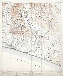
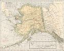
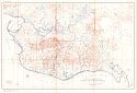
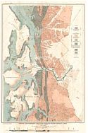
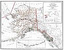
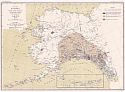
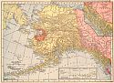
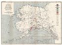
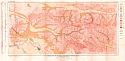
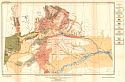
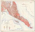
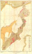
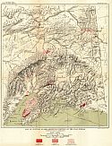
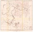
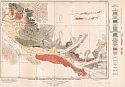
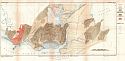
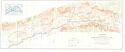
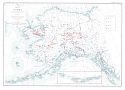
Historical Maps of Other Southeastern States

After 1905
Before 1895
1895-1905
After 1905

Previous Page

  Main Author:   U.S. Geological Survey
  Title/Description:   Nome Special Map
  Publication Info:   Washington: Department of the Interior, U.S. Geological Survey, 1906
  Date:   1906
  Scale:   1:62,500
  Original Source:   University of Alabama Map Library
Viewing options:


  Main Author:   U.S. Geological Survey
  Title/Description:   Grand Central Special Map
  Publication Info:   Washington: Department of the Interior, U.S. Geological Survey, 1906
  Date:   1906
  Scale:   1:62,500
  Original Source:   University of Alabama Map Library
Viewing options:


  Main Author:   Rand McNally and Company
  Title/Description:   Alaska
  Publication Info:   Chicago: Rand McNally and Company, 1906; from the The Business Atlas and Shippers Guide
  Date:   1906
  Scale:   1:7,856,640
  Original Source:   Courtesy of Murray Hudson, Halls, Tennessee
Viewing options:


  Main Author:   C.S. Hammond and Company
  Title/Description:   Alaska
  Publication Info:   New York: C.S. Hammond and Company, 1906; from The Pictorial Atlas of the World
  Date:   1906
  Scale:    
  Original Source:   Courtesy of Murray Hudson, Halls, Tennessee
Viewing options:
 

  Main Author:   U.S. Geological Survey
  Title/Description:   Reconnaissance Map of the Northern Portion of Kenai Peninsula, Alaska
  Publication Info:   Washington: Department of the Interior, U.S. Geological Survey, 1906; from Bulletin 277 Plate II
  Date:   1906
  Scale:   1:250,000
  Original Source:   Geological Survey of Alabama
Viewing options:


  Main Author:   U.S. Geological Survey
  Title/Description:   Geologoic Map of the Vicinty of Juneau, with Cross Section
  Publication Info:   Washington: Department of the Interior, U.S. Geological Survey, 1906; from Bulletin 287 Plate IV
  Date:   1906
  Scale:   1:62,500
  Original Source:   Geological Survey of Alabama
Viewing options:


  Main Author:   U.S. Geological Survey
  Title/Description:   Topographic Map of the Juneau Gold Belt, Alaska
  Publication Info:   Washington: Department of the Interior, U.S. Geological Survey, 1906; from Bulletin 287 Plate XXXVI
  Date:   1906
  Scale:   1:250,000
  Original Source:   Geological Survey of Alabama
Viewing options:


  Main Author:   U.S. Geological Survey
  Title/Description:   Geologic Map of the Juneau Gold Belt, Alaska
  Publication Info:   Washington: Department of the Interior, U.S. Geological Survey, 1906; from Bulletin 287 Plate XXXVII
  Date:   1906
  Scale:   1:250,000
  Original Source:   Geological Survey of Alabama
Viewing options:


  Main Author:   U.S. Geological Survey
  Title/Description:   Topographic Reconnaissance Map of Matanuska Valley and Adjacent Regions, Alaska
  Publication Info:   Washington: Department of the Interior, U.S. Geological Survey, 1906; from Bulletin 289 Plate I
  Date:   1906
  Scale:   1:360,000
  Original Source:   Geological Survey of Alabama
Viewing options:


  Main Author:   U.S. Geological Survey
  Title/Description:   Reconnaissance Map of Yukon-Tanana Region, Alaska, Circle Quadrangle
  Publication Info:   Washington: Department of the Interior, U.S. Geological Survey, 1906; from Bulletin 295 Plate I
  Date:   1906
  Scale:   1:250,000
  Original Source:   Geological Survey of Alabama
Viewing options:


  Main Author:   U.S. Geological Survey
  Title/Description:   Casadepaga Quadrangle
  Publication Info:   Washington: Department of the Interior, U.S. Geological Survey, 1907
  Date:   1907
  Scale:   1:62,500
  Original Source:   University of Alabama Map Library
Viewing options:


  Main Author:   U.S. Geological Survey
  Title/Description:   Solomon Quadrangle
  Publication Info:   Washington: Department of the Interior, U.S. Geological Survey, 1907
  Date:   1907
  Scale:   1:62,500
  Original Source:   University of Alabama Map Library
Viewing options:


  Main Author:   Cram, George F.
  Title/Description:   Alaska
  Publication Info:   Chicago: George F. Cram, 1907; from The Standard American Atlas
  Date:   1907
  Scale:   1:6,652,800
  Original Source:   University of Alabama Map Library
Viewing options:


  Main Author:   P.F. Collier and Son
  Title/Description:   Alaska
  Publication Info:   New York: P.F. Collier and Son, 1907; from The New Encyclopedic Atlas and Gazeteer of the World
  Date:   1907
  Scale:   1:10,137,600
  Original Source:   Courtesy of Murray Hudson, Halls, Tennessee
Viewing options:


  Main Author:   U.S. Geological Survey
  Title/Description:   Map of the Bering River Coal Field showing distribution of various kinds of coal and location of the coal sections and coal samples
  Publication Info:   Washington: Department of the Interior, U.S. Geological Survey, 1907; from Bulletin 335 Plate VIII
  Date:   1907
  Scale:   1:62,500
  Original Source:   Geological Survey of Alabama
Viewing options:


  Main Author:   U.S. Geological Survey
  Title/Description:   Geologic Map and Sections of Controller Bay Region, Alaska
  Publication Info:   Washington: Department of the Interior, U.S. Geological Survey, 1907; from Bulletin 335 Plate V
  Date:   1907
  Scale:   1:62,500
  Original Source:   Geological Survey of Alabama
Viewing options:


  Main Author:   U.S. Geological Survey
  Title/Description:   Topographic Map of Controller Bay Region, Alaska
  Publication Info:   Washington: Department of the Interior, U.S. Geological Survey, 1907; from Bulletin 335 Plate II
  Date:   1907
  Scale:   1:62,500
  Original Source:   Geological Survey of Alabama
Viewing options:


  Main Author:   U.S. Geological Survey
  Title/Description:   Topographic Reconnaissance Map of the Southern Part of Seward Peninsula
  Publication Info:   Washington: Department of the Interior, U.S. Geological Survey, 1907; from Bulletin 328 Plate VIII
  Date:   1907
  Scale:   1:250,000
  Original Source:   Geological Survey of Alabama
Viewing options:


  Main Author:   U.S. Geological Survey
  Title/Description:   Reconnaissance Map of the Northwestern Part of Seward Peninsula
  Publication Info:   Washington: Department of the Interior, U.S. Geological Survey, 1907; from Bulletin 328 Plate IX
  Date:   1907
  Scale:   1:250,000
  Original Source:   Geological Survey of Alabama
Viewing options:


  Main Author:   U.S. Geological Survey
  Title/Description:   Geologic Map of the Southern Part of Seward Peninsula
  Publication Info:   Washington: Department of the Interior, U.S. Geological Survey, 1907; from Bulletin 328 Plate X
  Date:   1907
  Scale:   1:250,000
  Original Source:   Geological Survey of Alabama
Viewing options:


  Main Author:   U.S. Geological Survey
  Title/Description:   Geologic Reconnaissance Map of the Northwestern Part of Seward Peninsula
  Publication Info:   Washington: Department of the Interior, U.S. Geological Survey, 1907; from Bulletin 328 Plate XI
  Date:   1907
  Scale:   1:250,000
  Original Source:   Geological Survey of Alabama
Viewing options:


  Main Author:   U.S. Geological Survey
  Title/Description:   Reconnaissance Map of Matanuska and Talkeeta Region, Alaska
  Publication Info:   Washington: Department of the Interior, U.S. Geological Survey, 1907; from Bulletin 327 Plate I
  Date:   1907
  Scale:   1:250,000
  Original Source:   Geological Survey of Alabama
Viewing options:


  Main Author:   U.S. Geological Survey
  Title/Description:   Geologic Reconnaissance Map of Matanuska and Talkeeta Region, Alaska
  Publication Info:   Washington: Department of the Interior, U.S. Geological Survey, 1907; from Bulletin 327 Plate II
  Date:   1907
  Scale:   1:250,000
  Original Source:   Geological Survey of Alabama
Viewing options:


  Main Author:   U.S. Geological Survey
  Title/Description:   Geologic Reconnaissance Map of the Kelchikan and Wrangell Mining Districts, Southeastern Alaska
  Publication Info:   Washington: Department of the Interior, U.S. Geological Survey, 1907; from Bulletin 347 Plate I
  Date:   1907
  Scale:   1:887,040
  Original Source:   Geological Survey of Alabama
Viewing options:


  Main Author:   U.S. Geological Survey
  Title/Description:   Geologic Reconnaissance Map of part of the Kelchikan Mining District, Alaska
  Publication Info:   Washington: Department of the Interior, U.S. Geological Survey, 1907; from Bulletin 347 Plate II
  Date:   1907
  Scale:   1:250,000
  Original Source:   Geological Survey of Alabama
Viewing options:


  Main Author:   U.S. Geological Survey
  Title/Description:   Geologic Reconnaissance Map of part of the Wrangell Mining District, Alaska
  Publication Info:   Washington: Department of the Interior, U.S. Geological Survey, 1907; from Bulletin 347 Plate III
  Date:   1907
  Scale:   1:250,000
  Original Source:   Geological Survey of Alabama
Viewing options:


  Main Author:   U.S. Geological Survey
  Title/Description:   Reconnaissance Map of the Fairbanks Quadrangle, Alaska
  Publication Info:   Washington: Department of the Interior, U.S. Geological Survey, 1907; from Bulletin 337 Plate IV
  Date:   1907
  Scale:   1:62,500
  Original Source:   Geological Survey of Alabama
Viewing options:


  Main Author:   U.S. Geological Survey
  Title/Description:   Reconnaissance Map of Rampart Quadrangle, Yukon-Tanana Region, Alaska,
  Publication Info:   Washington: Department of the Interior, U.S. Geological Survey, 1907; from Bulletin 337 Plate V
  Date:   1907
  Scale:   1:250,000
  Original Source:   Geological Survey of Alabama
Viewing options:


  Main Author:   U.S. Geological Survey
  Title/Description:   Berners Bay Special Map
  Publication Info:   Washington: Department of the Interior, U.S. Geological Survey, 1908
  Date:   1908
  Scale:   1:62,500
  Original Source:   University of Alabama Map Library
Viewing options:


  Main Author:   Berthrong, I.P.
  Title/Description:   Alaska
  Publication Info:   Washington: Department of the Interior, General Land Office, 1908
  Date:   1908
  Scale:   1:3,168,000
  Original Source:   Courtesy of Murray Hudson, Halls, Tennessee
Viewing options:


  Main Author:   U.S. Geological Survey
  Title/Description:   Reconnaissance Map of Chitna Quadrangle, Copper River Region, Alaska
  Publication Info:   Washington: Department of the Interior, U.S. Geological Survey, 1908; from Bulletin 374 Plate I
  Date:   1908
  Scale:   1:250,000
  Original Source:   Geological Survey of Alabama
Viewing options:


  Main Author:   U.S. Geological Survey
  Title/Description:   Geologic Reconnaissance Map and Sections of the Chitna Copper Belt, Alaska
  Publication Info:   Washington: Department of the Interior, U.S. Geological Survey, 1908; from Bulletin 374 Plate II
  Date:   1908
  Scale:   1:250,000
  Original Source:   Geological Survey of Alabama
Viewing options:


  Main Author:   U.S. Geological Survey
  Title/Description:   Map of alaska showing the known distribution of mineral resources
  Publication Info:   Washington: Department of the Interior, U.S. Geological Survey, 1908; from Bulletin 345 Plate I
  Date:   1908
  Scale:   1:5,000,000
  Original Source:   Geological Survey of Alabama
Viewing options:


  Main Author:   U.S. Geological Survey
  Title/Description:   Topographic Reconnaissance Map of Fortymile Quadrangle
  Publication Info:   Washington: Department of the Interior, U.S. Geological Survey, 1908; from Bulletin 375 Plate IV
  Date:   1908
  Scale:   1:250,000
  Original Source:   Geological Survey of Alabama
Viewing options:


  Main Author:   U.S. Geological Survey
  Title/Description:   Geologic Reconnaissance Map of Fortymile Quadrangle
  Publication Info:   Washington: Department of the Interior, U.S. Geological Survey, 1908; from Bulletin 375 Plate V
  Date:   1908
  Scale:   1:250,000
  Original Source:   Geological Survey of Alabama
Viewing options:


  Main Author:   Patten, William and J.E. Homas
  Title/Description:   Alaska
  Publication Info:   New York: P.F. Collier and Son, 1909; from The New Encyclopedic Atlas and Gazetteer of the World
  Date:   1909
  Scale:   1:10,137,600
  Original Source:   University of Alabama Map Library
Viewing options:


  Main Author:   Cram, George F.
  Title/Description:   Alaska
  Publication Info:   Chicago: George F. Cram, 1909; from The Art of our Country
  Date:   1909
  Scale:   1:7,920,000
  Original Source:   Courtesy of Murray Hudson, Halls, Tennessee
Viewing options:


  Main Author:   U.S. Geological Survey
  Title/Description:   Map of Alaska Showing the area disturbed by sensible shocks during the earthquakes of September, 1899 in and around Yakutat Bay
  Publication Info:   Washington: Department of the Interior, U.S. Geological Survey, 1909; from Professional Paper No. 69 Plate XXXIII
  Date:   1909
  Scale:   1:5,000,000
  Original Source:   Geological Survey of Alabama
Viewing options:


  Main Author:   U.S. Geological Survey
  Title/Description:   Geologic Reconnaissance Map of the Yakutat Bay Region, Alaska
  Publication Info:   Washington: Department of the Interior, U.S. Geological Survey, 1909; from Professional Paper No. 69 Plate XXI1
  Date:   1909
  Scale:   1:312,500
  Original Source:   Geological Survey of Alabama
Viewing options:


  Main Author:   U.S. Geological Survey
  Title/Description:   Reconnaissance Map of the Middle Kuskokwin and Lower Yukon Regions
  Publication Info:   Washington: Department of the Interior, U.S. Geological Survey, 1909; from Bulletin 410 Plate I
  Date:   1909
  Scale:   1:625,000
  Original Source:   Geological Survey of Alabama
Viewing options:


  Main Author:   U.S. Geological Survey
  Title/Description:   Geologic Reconnaissance Map of Prince William Sound, Alaska
  Publication Info:   Washington: Department of the Interior, U.S. Geological Survey, 1909; from Bulletin 443 Plate II
  Date:   1909
  Scale:   1:250,000
  Original Source:   Geological Survey of Alabama
Viewing options:


  Main Author:   U.S. Geological Survey
  Title/Description:   Topographic and Geologic Reconnaissance Map of Part of Latouche Island, Prince William Sound, Alaska
  Publication Info:   Washington: Department of the Interior, U.S. Geological Survey, 1909; from Bulletin 443 Plate XII
  Date:   1909
  Scale:   1:21,120
  Original Source:   Geological Survey of Alabama
Viewing options:


  Main Author:   U.S. Geological Survey
  Title/Description:   Geologic Map of the Solomon Quadrangle, Alaska
  Publication Info:   Washington: Department of the Interior, U.S. Geological Survey, 1909; from Bulletin 433 Plate VI
  Date:   1909
  Scale:   1:62,000
  Original Source:   Geological Survey of Alabama
Viewing options:


  Main Author:   U.S. Geological Survey
  Title/Description:   Geologic Map of the Casadepaga Quadrangle, Alaska
  Publication Info:   Washington: Department of the Interior, U.S. Geological Survey, 1909; from Bulletin 433 Plate VII
  Date:   1909
  Scale:   1:62,500
  Original Source:   Geological Survey of Alabama
Viewing options:


  Main Author:   U.S. Geological Survey
  Title/Description:   Reconnaissance Map of Headwater Region of Nabesna and White Rivers, Alaska
  Publication Info:   Washington: Department of the Interior, U.S. Geological Survey, 1909; from Bulletin 417 Plate I
  Date:   1909
  Scale:   1:250,000
  Original Source:   Geological Survey of Alabama
Viewing options:


  Main Author:   U.S. Geological Survey
  Title/Description:   Geologic Reconnaissance Map of Headwater Region of Nabesna and White Rivers, Alaska
  Publication Info:   Washington: Department of the Interior, U.S. Geological Survey, 1909; from Bulletin 417 Plate II
  Date:   1909
  Scale:   1:250,000
  Original Source:   Geological Survey of Alabama
Viewing options:


  Main Author:   Rand McNally and Company
  Title/Description:   Alaska
  Publication Info:   Chicago: Rand McNally and Company, 1910; from The Enlarged Business Atlas and Shippers Guide
  Date:   1910
  Scale:   1:5,892,480
  Original Source:   Courtesy of Murray Hudson, Halls, Tennessee
Viewing options:


  Main Author:   U.S. Geological Survey
  Title/Description:   Geologic Reconnaissance Map of the Yenta Mining District, Alaska
  Publication Info:   Washington: Department of the Interior, U.S. Geological Survey, 1910; from Professional Paper No. 70 Plate XV
  Date:   1910
  Scale:   1:250,000
  Original Source:   Geological Survey of Alabama
Viewing options:


  Main Author:   U.S. Geological Survey
  Title/Description:   Geologic Map of Berners Bay Region, Alaska
  Publication Info:   Washington: Department of the Interior, U.S. Geological Survey, 1910; from Bulletin 446 Plate II
  Date:   1909
  Scale:   1:62,500
  Original Source:   Geological Survey of Alabama
Viewing options:


  Main Author:   U.S. Geological Survey
  Title/Description:   Geologic Map of Nulato-Norton Bay Region, Alaska
  Publication Info:   Washington: Department of the Interior, U.S. Geological Survey, 1910; from Bulletin 449 Plate V
  Date:   1910
  Scale:   1:500,000
  Original Source:   Geological Survey of Alabama
Viewing options:


  Main Author:   U.S. Geological Survey
  Title/Description:   Geologic Reconnaissance Map of the Mt. McKinley Region, Alaska
  Publication Info:   Washington: Department of the Interior, U.S. Geological Survey, 1911; from Professional Paper No. 70 Plate IX
  Date:   1911
  Scale:   1:625,000
  Original Source:   Geological Survey of Alabama
Viewing options:


  Main Author:   U.S. Geological Survey
  Title/Description:   Reconnaissance Map of the Mt. McKinley Region, Alaska
  Publication Info:   Washington: Department of the Interior, U.S. Geological Survey, 1911; from Professional Paper No. 70 Plate III
  Date:   1911
  Scale:   1:625,000
  Original Source:   Geological Survey of Alabama
Viewing options:


  Main Author:   Rand McNally and Company
  Title/Description:   Alaska
  Publication Info:   Chicago: Rand McNally & Co., 1911; from The Indexed Atlas
  Date:   1911
  Scale:   1:5,892,000
  Original Source:   Courtesy of Murray Hudson, Halls, Tennessee
Viewing options:


  Main Author:   C.S. Hammond and Company
  Title/Description:   Alaska
  Publication Info:   New York: C.S. Hammond and Company, 1911; from The Modern Atlas of the World
  Date:   1911
  Scale:   1:11,088,000
  Original Source:   Courtesy of Murray Hudson, Halls, Tennessee
Viewing options:


  Main Author:    
  Title/Description:   Alaska
  Publication Info:   Chicago: Geographical Publishing Company, 1911
  Date:   1911
  Scale:   1:12,672 ,000
  Original Source:   Courtesy of Murray Hudson, Halls, Tennessee
Viewing options:


  Main Author:   U.S. Geological Survey
  Title/Description:   Geologic Map of the Nizina District, Alaska
  Publication Info:   Washington: Department of the Interior, U.S. Geological Survey, 1911; from Bulletin 448 Plate III
  Date:   1911
  Scale:   1:62,500
  Original Source:   Geological Survey of Alabama
Viewing options:


  Main Author:   U.S. Geological Survey
  Title/Description:   Topographic Map of the Nizina District, Alaska
  Publication Info:   Washington: Department of the Interior, U.S. Geological Survey, 1911; from Bulletin 448 Plate II
  Date:   1911
  Scale:   1:62,500
  Original Source:   Geological Survey of Alabama
Viewing options:


  Main Author:   U.S. Geological Survey
  Title/Description:   Reconnaissance Map of Southeastern Seward Peninsula, Alaska
  Publication Info:   Washington: Department of the Interior, U.S. Geological Survey, 1911; from Bulletin 449 Plate I
  Date:   1911
  Scale:   1:250,000
  Original Source:   Geological Survey of Alabama
Viewing options:


  Main Author:   U.S. Geological Survey
  Title/Description:   Geologic Map of Southeastern Seward Peninsula, Alaska
  Publication Info:   Washington: Department of the Interior, U.S. Geological Survey, 1911; from Bulletin 449 Plate VI
  Date:   1911
  Scale:   1:250,000
  Original Source:   Geological Survey of Alabama
Viewing options:


  Main Author:   U.S. Geological Survey
  Title/Description:   Geologic Map of the Alaska Peninsula
  Publication Info:   Washington: Department of the Interior, U.S. Geological Survey, 1911; from Bulletin 449 Plate VI
  Date:   1911
  Scale:   1:1,000,000
  Original Source:   Geological Survey of Alabama
Viewing options:


  Main Author:   U.S. Geological Survey
  Title/Description:   Map of Alaska Showing Distribution of Metalliferous Deposits
  Publication Info:   Washington: Department of the Interior, U.S. Geological Survey, 1911; from Bulletin 480 Plate I
  Date:   1911
  Scale:   1:5,000,000
  Original Source:   Geological Survey of Alabama
Viewing options:


  Main Author:   U.S. Geological Survey
  Title/Description:   Reconnaissance Map of Circle Quadrangle, Yukon-Tanana Region, Alaska
  Publication Info:   Washington: Department of the Interior, U.S. Geological Survey, 1911; from Bulletin 538 Plate I
  Date:   1911
  Scale:   1:250,000
  Original Source:   Geological Survey of Alabama
Viewing options:


  Main Author:   U.S. Geological Survey
  Title/Description:   Geologic Reconnaissance Map of Circle Quadrangle, Yukon-Tanana Region, Alaska
  Publication Info:   Washington: Department of the Interior, U.S. Geological Survey, 1911; from Bulletin 538 Plate II
  Date:   1911
  Scale:   1:250,000
  Original Source:   Geological Survey of Alabama
Viewing options:


  Main Author:   U.S. Geological Survey
  Title/Description:   Geologic Reconnaissance Map of the Iliamna Region
  Publication Info:   Washington: Department of the Interior, U.S. Geological Survey, 1912
  Date:   1912
  Scale:   1:250,000
  Original Source:   Geological Survey of Alabama
Viewing options:


  Main Author:   Rand McNally and Company
  Title/Description:   Alaska
  Publication Info:   Chicago: Rand McNally and Company; from The Rand McNally Imperial Atlas of the World
  Date:   1912
  Scale:   1:8,363,520
  Original Source:   Courtesy of Murray Hudson, Halls, Tennessee
Viewing options:


  Main Author:   U.S. Geological Survey
  Title/Description:   Map of the Lower Matanuska Valley, Alaska
  Publication Info:   Washington: Department of the Interior, U.S. Geological Survey, 1912; from Bulletin 500 Plate XVIII
  Date:   1912
  Scale:   1:62,500
  Original Source:   Geological Survey of Alabama
Viewing options:


  Main Author:   U.S. Geological Survey
  Title/Description:   Geologic Reconnaissance Map of the Lower Matanuska Valley, Alaska
  Publication Info:   Washington: Department of the Interior, U.S. Geological Survey, 1912; from Bulletin 500 Plate III
  Date:   1912
  Scale:   1:250,000
  Original Source:   Geological Survey of Alabama
Viewing options:


  Main Author:   U.S. Geological Survey
  Title/Description:   Geologic Map of the Lower Matanuska Valley, Alaska
  Publication Info:   Washington: Department of the Interior, U.S. Geological Survey, 1912; from Bulletin 500 Plate V
  Date:   1912
  Scale:   1:62,500
  Original Source:   Geological Survey of Alabama
Viewing options:


  Main Author:   U.S. Geological Survey
  Title/Description:   Map of Central Alaska, Showing Positions of the Coal Fields
  Publication Info:   Washington: Department of the Interior, U.S. Geological Survey, 1912; from Bulletin 500 Plate I
  Date:   1912
  Scale:   1:2,500,000
  Original Source:   Geological Survey of Alabama
Viewing options:


  Main Author:   U.S. Geological Survey
  Title/Description:   Reconnaissance Map of Headwater Region of Gulkana and Susitna Rivers, Alaska
  Publication Info:   Washington: Department of the Interior, U.S. Geological Survey, 1912; from Bulletin 498 Plate I
  Date:   1912
  Scale:   1:250,000
  Original Source:   Geological Survey of Alabama
Viewing options:


  Main Author:   U.S. Geological Survey
  Title/Description:   Geologic Reconnaissance Map of Headwater Region of Gulkana and Susitna Rivers, Alaska
  Publication Info:   Washington: Department of the Interior, U.S. Geological Survey, 1912; from Bulletin 498 Plate II
  Date:   1912
  Scale:   1:250,000
  Original Source:   Geological Survey of Alabama
Viewing options:


  Main Author:   U.S. Geological Survey
  Title/Description:   Reconnaissance Map of Illamna Region, Alaska
  Publication Info:   Washington: Department of the Interior, U.S. Geological Survey, 1912; from Bulletin 485 Plate I
  Date:   1912
  Scale:   1:250,000
  Original Source:   Geological Survey of Alabama
Viewing options:


  Main Author:   U.S. Geological Survey
  Title/Description:   Geologic Reconnaissance Map of Illamna Region, Alaska
  Publication Info:   Washington: Department of the Interior, U.S. Geological Survey, 1912; from Bulletin 485 Plate II
  Date:   1912
  Scale:   1:250,000
  Original Source:   Geological Survey of Alabama
Viewing options:


  Main Author:   U.S. Geological Survey
  Title/Description:   Map of Alaska Showing Distribution of Mineral Deposits
  Publication Info:   Washington: Department of the Interior, U.S. Geological Survey, 1912; from Bulletin 520 Plate I
  Date:   1912
  Scale:   1:5,000,000
  Original Source:   Geological Survey of Alabama
Viewing options:


  Main Author:   U.S. Geological Survey
  Title/Description:   Relief Map of Central Alaska
  Publication Info:   Washington: Department of the Interior, U.S. Geological Survey, 1912; from Bulletin 520 Plate III
  Date:   1912
  Scale:   1:2,500,000
  Original Source:   Geological Survey of Alabama
Viewing options:


  Main Author:   U.S. Geological Survey
  Title/Description:   Topographic Map of the Eagle River Region, Alaska
  Publication Info:   Washington: Department of the Interior, U.S. Geological Survey, 1912; from Bulletin 502 Plate I
  Date:   1912
  Scale:   1:62,500
  Original Source:   Geological Survey of Alabama
Viewing options:


  Main Author:   U.S. Geological Survey
  Title/Description:   Geologic Map of the Eagle River Region, Alaska
  Publication Info:   Washington: Department of the Interior, U.S. Geological Survey, 1912; from Bulletin 502 Plate II
  Date:   1912
  Scale:   1:62,500
  Original Source:   Geological Survey of Alabama
Viewing options:


  Main Author:   U.S. Geological Survey
  Title/Description:   Reconnaissance Map of the Bonnifield Region, Alaska
  Publication Info:   Washington: Department of the Interior, U.S. Geological Survey, 1912; from Bulletin 501 Plate I
  Date:   1912
  Scale:   1:250,000
  Original Source:   Geological Survey of Alabama
Viewing options:


  Main Author:   U.S. Geological Survey
  Title/Description:   Geologic Reconnaissance Map of the Bonnifield Region, Alaska
  Publication Info:   Washington: Department of the Interior, U.S. Geological Survey, 1912; from Bulletin 501 Plate II
  Date:   1912
  Scale:   1:250,000
  Original Source:   Geological Survey of Alabama
Viewing options:


  Main Author:   The Century Company
  Title/Description:   Alaska
  Publication Info:   New York: The Century Company, 1913; from The Century Atlas of the World
  Date:   1913
  Scale:   1:6,969,600
  Original Source:   University of Alabama Map Library
Viewing options:


  Main Author:   U.S. Geological Survey
  Title/Description:   Map of Prince William Sound, Alaska
  Publication Info:   Washington: Department of the Interior, U.S. Geological Survey, 1913; from Bulletin 526 Plate I
  Date:   1913
  Scale:   1:500,000
  Original Source:   Geological Survey of Alabama
Viewing options:


  Main Author:   U.S. Geological Survey
  Title/Description:   Reconnaissance Map of the Southwestern part of Kenai Peninsula, Alaska
  Publication Info:   Washington: Department of the Interior, U.S. Geological Survey, 1913; from Bulletin 526 Plate II
  Date:   1913
  Scale:   1:500,000
  Original Source:   Geological Survey of Alabama
Viewing options:


  Main Author:   U.S. Geological Survey
  Title/Description:   Reconnaissance Map of the Fairbanks Quadrangle, Alaska
  Publication Info:   Washington: Department of the Interior, U.S. Geological Survey, 1913; from Bulletin 525 Plate I
  Date:   1913
  Scale:   1:250,000
  Original Source:   Geological Survey of Alabama
Viewing options:


  Main Author:   U.S. Geological Survey
  Title/Description:   Topographic and Economic Map of the Fairbanks District, Alaska
  Publication Info:   Washington: Department of the Interior, U.S. Geological Survey, 1913; from Bulletin 525 Plate II
  Date:   1913
  Scale:   1:62,500
  Original Source:   Geological Survey of Alabama
Viewing options:


  Main Author:   U.S. Geological Survey
  Title/Description:   Geologic Reconnaissance Map of the Fairbanks Quadrangle, Alaska
  Publication Info:   Washington: Department of the Interior, U.S. Geological Survey, 1913; from Bulletin 525 Plate VIII
  Date:   1913
  Scale:   1:250,000
  Original Source:   Geological Survey of Alabama
Viewing options:


  Main Author:   U.S. Geological Survey
  Title/Description:   Geologic Map and Sections of the Fairbanks District, Alaska
  Publication Info:   Washington: Department of the Interior, U.S. Geological Survey, 1913; from Bulletin 525 Plate XI
  Date:   1913
  Scale:   1:62,500
  Original Source:   Geological Survey of Alabama
Viewing options:


  Main Author:   U.S. Geological Survey
  Title/Description:   Reconnaissance Map of the Noatak-Kobuk Region, Alaska
  Publication Info:   Washington: Department of the Interior, U.S. Geological Survey, 1913; from Bulletin 536 Plate I
  Date:   1913
  Scale:   1:500,000
  Original Source:   Geological Survey of Alabama
Viewing options:


  Main Author:   U.S. Geological Survey
  Title/Description:   Reconnaissance Geologic Map of the Noatak-Kobuk Region, Alaska
  Publication Info:   Washington: Department of the Interior, U.S. Geological Survey, 1913; from Bulletin 536 Plate II
  Date:   1913
  Scale:   1:500,000
  Original Source:   Geological Survey of Alabama
Viewing options:


  Main Author:   U.S. Geological Survey
  Title/Description:   Reconnaissance Map of part of the Rampart Quadrangle, Alaska
  Publication Info:   Washington: Department of the Interior, U.S. Geological Survey, 1913; from Bulletin 535 Plate I
  Date:   1913
  Scale:   1:250,000
  Original Source:   Geological Survey of Alabama
Viewing options:


  Main Author:   U.S. Geological Survey
  Title/Description:   Geologic Map of part of the Rampart Quadrangle, Alaska
  Publication Info:   Washington: Department of the Interior, U.S. Geological Survey, 1913; from Bulletin 535 Plate IV
  Date:   1913
  Scale:   1:250,000
  Original Source:   Geological Survey of Alabama
Viewing options:


  Main Author:   U.S. Geological Survey
  Title/Description:   Reconnaissance Map of the Yentna District, Alaska
  Publication Info:   Washington: Department of the Interior, U.S. Geological Survey, 1913; from Bulletin 534 Plate II
  Date:   1913
  Scale:   1:250,000
  Original Source:   Geological Survey of Alabama
Viewing options:


  Main Author:   U.S. Geological Survey
  Title/Description:   Geologic Reconnaissance Map of the Yentna District, Alaska
  Publication Info:   Washington: Department of the Interior, U.S. Geological Survey, 1913; from Bulletin 534 Plate III
  Date:   1913
  Scale:   1:250,000
  Original Source:   Geological Survey of Alabama
Viewing options:


  Main Author:   U.S. Geological Survey
  Title/Description:   Topographic Map of the Nome Quadrangle, Alaska
  Publication Info:   Washington: Department of the Interior, U.S. Geological Survey, 1913; from Bulletin 533 Plate I
  Date:   1913
  Scale:   1:62,500
  Original Source:   Geological Survey of Alabama
Viewing options:


  Main Author:   U.S. Geological Survey
  Title/Description:   Topographic Map of the Grand Central Quadrangle, Alaska
  Publication Info:   Washington: Department of the Interior, U.S. Geological Survey, 1913; from Bulletin 533 Plate II
  Date:   1913
  Scale:   1:62,500
  Original Source:   Geological Survey of Alabama
Viewing options:


  Main Author:   U.S. Geological Survey
  Title/Description:   Geologic Map of the Nome Quadrangle, Alaska
  Publication Info:   Washington: Department of the Interior, U.S. Geological Survey, 1913; from Bulletin 533 Plate III
  Date:   1913
  Scale:   1:62,500
  Original Source:   Geological Survey of Alabama
Viewing options:


  Main Author:   U.S. Geological Survey
  Title/Description:   Geologic Map of the Grand Central Quadrangle, Alaska
  Publication Info:   Washington: Department of the Interior, U.S. Geological Survey, 1913; from Bulletin 533 Plate II
  Date:   1913
  Scale:   1:62,500
  Original Source:   Geological Survey of Alabama
Viewing options:


  Main Author:   U.S. Geological Survey
  Title/Description:   Reconnaissance Map of Koyukuk-Chandalar Region, Alaska
  Publication Info:   Washington: Department of the Interior, U.S. Geological Survey, 1913; from Bulletin 532 Plate I
  Date:   1913
  Scale:   1:500,000
  Original Source:   Geological Survey of Alabama
Viewing options:


  Main Author:   U.S. Geological Survey
  Title/Description:   Reconnaissance Geologic Map of Koyukuk-Chandalar Region, Alaska
  Publication Info:   Washington: Department of the Interior, U.S. Geological Survey, 1913; from Bulletin 532 Plate V
  Date:   1913
  Scale:   1:500,000
  Original Source:   Geological Survey of Alabama
Viewing options:


  Main Author:   Rand McNally and Company
  Title/Description:   Alaska
  Publication Info:   Chicago: Rand McNally and Company, 1914; from The Commercial Atlas of America
  Date:   1914
  Scale:   1:5,702,400
  Original Source:   Courtesy of Murray Hudson, Halls, Tennessee
Viewing options:


  Main Author:   U.S. Geological Survey
  Title/Description:   Reconnaissance Map of the Iditarod - Ruby Region, Alaska
  Publication Info:   Washington: Department of the Interior, U.S. Geological Survey, 1914; Bulletin 578, Plate 2
  Date:   1914
  Scale:   1:250,000
  Original Source:   University of Alabama Map Library
Viewing options:


  Main Author:   Reynolds, Francis J.
  Title/Description:   Alaska
  Publication Info:   New York: P.F.Collier and Son, 1914; from the Encyclopedic Atlas and Gazetteer of the World
  Date:   1914
  Scale:   1:10,137,600
  Original Source:   Courtesy of Murray Hudson, Halls, Tennessee
Viewing options:


  Main Author:   U.S. Geological Survey
  Title/Description:   Geologic Map of Kassan Peninsula, Prince of Wales Island, Alaska
  Publication Info:   Washington: Department of the Interior, U.S. Geological Survey, 1914; from Professional Paper No. 87 Plate XV
  Date:   1914
  Scale:   1:62,500
  Original Source:   Geological Survey of Alabama
Viewing options:


  Main Author:   U.S. Geological Survey
  Title/Description:   Topographic Map of Kassan Peninsula, Prince of Wales Island, Alaska
  Publication Info:   Washington: Department of the Interior, U.S. Geological Survey, 1914; from Professional Paper No. 87 Plate XIII
  Date:   1914
  Scale:   1:62,500
  Original Source:   Geological Survey of Alabama
Viewing options:


  Main Author:   U.S. Geological Survey
  Title/Description:   Reconnaissance Map of the Middle Kuskokwim and Lower Yukon Region, Alaska
  Publication Info:   Washington: Department of the Interior, U.S. Geological Survey, 1914; from Bulletin 578 Plate I
  Date:   1914
  Scale:   1:500,000
  Original Source:   Geological Survey of Alabama
Viewing options:


  Main Author:   U.S. Geological Survey
  Title/Description:   Reconnaissance Map of the Iditarod-Ruby Region, Alaska
  Publication Info:   Washington: Department of the Interior, U.S. Geological Survey, 1914; from Bulletin 578 Plate II
  Date:   1914
  Scale:   1:250,000
  Original Source:   Geological Survey of Alabama
Viewing options:


  Main Author:   U.S. Geological Survey
  Title/Description:   Geologic Reconnaissance Map of the Iditarod-Ruby Region, Alaska
  Publication Info:   Washington: Department of the Interior, U.S. Geological Survey, 1914; from Bulletin 578 Plate III
  Date:   1914
  Scale:   1:250,000
  Original Source:   Geological Survey of Alabama
Viewing options:


  Main Author:   U.S. Geological Survey
  Title/Description:   Reconnaissance Map of Chitina Quadrangle, Copper River Region, Alaska
  Publication Info:   Washington: Department of the Interior, U.S. Geological Survey, 1914; from Bulletin 576 Plate I
  Date:   1914
  Scale:   1:250,000
  Original Source:   Geological Survey of Alabama
Viewing options:


  Main Author:   U.S. Geological Survey
  Title/Description:   Geologic Reconnaissance Map of Hanagita-Bremner Region, Alaska
  Publication Info:   Washington: Department of the Interior, U.S. Geological Survey, 1914; from Bulletin 576 Plate II
  Date:   1914
  Scale:   1:250,000
  Original Source:   Geological Survey of Alabama
Viewing options:


  Main Author:   U.S. Geological Survey
  Title/Description:   Map of Alaska showing distribution of mineral depsoits
  Publication Info:   Washington: Department of the Interior, U.S. Geological Survey, 1914; from Bulletin 592 Plate I
  Date:   1914
  Scale:   1:5,000,000
  Original Source:   Geological Survey of Alabama
Viewing options:


  Main Author:   U.S. Geological Survey
  Title/Description:   Map of Central Alaska Showing Position of the Coal Fields
  Publication Info:   Washington: Department of the Interior, U.S. Geological Survey, 1914; from Bulletin 587 Plate I
  Date:   1914
  Scale:   1:2,500,000
  Original Source:   Geological Survey of Alabama
Viewing options:


  Main Author:   U.S. Geological Survey
  Title/Description:   Topographic Reconnaissance Map of Kenai Peninisula, Alaska
  Publication Info:   Washington: Department of the Interior, U.S. Geological Survey, 1915; from Bulletin 587 Plate II
  Date:   1915
  Scale:   1:250,000
  Original Source:   Geological Survey of Alabama
Viewing options:


  Main Author:   U.S. Geological Survey
  Title/Description:   Geologic Reconnaissance Map of Kenai Peninisula, Alaska
  Publication Info:   Washington: Department of the Interior, U.S. Geological Survey, 1915; from Bulletin 587 Plate III
  Date:   1915
  Scale:   1:250,000
  Original Source:   Geological Survey of Alabama
Viewing options:


  Main Author:   U.S. Geological Survey
  Title/Description:   Topographic Map of Moose Pass and Vicinity, Kenai Peninisula, Alaska
  Publication Info:   Washington: Department of the Interior, U.S. Geological Survey, 1915; from Bulletin 587 Plate IV
  Date:   1915
  Scale:   1:62,500
  Original Source:   Geological Survey of Alabama
Viewing options:


  Main Author:   U.S. Geological Survey
  Title/Description:   Reconnaissance Map of the Broad Pass Region, Alaska
  Publication Info:   Washington: Department of the Interior, U.S. Geological Survey, 1915; from Bulletin 608 Plate I
  Date:   1915
  Scale:   1:250,000
  Original Source:   Geological Survey of Alabama
Viewing options:


  Main Author:   U.S. Geological Survey
  Title/Description:   Geologic Reconnaissance Map of the Broad Pass Region, Alaska
  Publication Info:   Washington: Department of the Interior, U.S. Geological Survey, 1915; from Bulletin 608 Plate II
  Date:   1915
  Scale:   1:250,000
  Original Source:   Geological Survey of Alabama
Viewing options:


  Main Author:   U.S. Geological Survey
  Title/Description:   Geologic Map of Willow Creek District, Alaska
  Publication Info:   Washington: Department of the Interior, U.S. Geological Survey, 1915; from Bulletin 607 Plate III
  Date:   1915
  Scale:   1:62,500
  Original Source:   Geological Survey of Alabama
Viewing options:


  Main Author:   U.S. Geological Survey
  Title/Description:   Topographic Map of Willow Creek District, Alaska
  Publication Info:   Washington: Department of the Interior, U.S. Geological Survey, 1915; from Bulletin 607 Plate II
  Date:   1915
  Scale:   1:62,500
  Original Source:   Geological Survey of Alabama
Viewing options:


  Main Author:   U.S. Geological Survey
  Title/Description:   Geologic Map and Sections of Ellamar District, Prince William Sound, Alaska
  Publication Info:   Washington: Department of the Interior, U.S. Geological Survey, 1915; from Bulletin 605 Plate II
  Date:   1915
  Scale:   1:62,500
  Original Source:   Geological Survey of Alabama
Viewing options:


  Main Author:   U.S. Geological Survey
  Title/Description:   Topographic Map and Sections of Ellamar District, Prince William Sound, Alaska
  Publication Info:   Washington: Department of the Interior, U.S. Geological Survey, 1915; from Bulletin 605 Plate I
  Date:   1915
  Scale:   1:62,500
  Original Source:   Geological Survey of Alabama
Viewing options:


  Main Author:   U.S. Geological Survey
  Title/Description:   Map of the Port Valdez District, Showing Mines and Prospects
  Publication Info:   Washington: Department of the Interior, U.S. Geological Survey, 1915; from Bulletin 622 Plate VIII
  Date:   1915
  Scale:   1:125,000
  Original Source:   Geological Survey of Alabama
Viewing options:


  Main Author:   U.S. Geological Survey
  Title/Description:  

Map of Prince William Sound, Showing Mineral Resources

  Publication Info:   Washington: Department of the Interior, U.S. Geological Survey, 1915; from Bulletin 622 Plate VII
  Date:   1915
  Scale:   1:500,000
  Original Source:   Geological Survey of Alabama
Viewing options:


  Main Author:   U.S. Geological Survey
  Title/Description:   Geologic Sketch Map of the Nelchina-Susitina Region
  Publication Info:   Washington: Department of the Interior, U.S. Geological Survey, 1915; from Bulletin 622 Plate VI
  Date:   1915
  Scale:   1:500,000
  Original Source:   Geological Survey of Alabama
Viewing options:


  Main Author:   U.S. Geological Survey
  Title/Description:   Map Showing Mineral Resources of Lower River Region, Alaska
  Publication Info:   Washington: Department of the Interior, U.S. Geological Survey, 1915; from Bulletin 649 Plate I
  Date:   1915
  Scale:   1:500,000
  Original Source:   Geological Survey of Alabama
Viewing options:


  Main Author:   Rand McNally and Company
  Title/Description:   Alaska
  Publication Info:   Chicago: Rand McNally and Company, 1916; from The Ideal Atlas of the World
  Date:   1916
  Scale:   1:8,363,520
  Original Source:   Courtesy of Murray Hudson, Halls, Tennessee
Viewing options:


  Main Author:   U.S. Geological Survey
  Title/Description:   Map of Alaska showing distribution of Antimony Deposits
  Publication Info:   Washington: Department of the Interior, U.S. Geological Survey, 1916; from Bulletin 649 Plate I
  Date:   1916
  Scale:   1:5,000,000
  Original Source:   Geological Survey of Alabama
Viewing options:


  Main Author:   U.S. Geological Survey
  Title/Description:   Reconnaissance Map of Yukon-Koyukuk Region, Alaska
  Publication Info:   Washington: Department of the Interior, U.S. Geological Survey, 1916; from Bulletin 631 Plate I
  Date:   1916
  Scale:   1:500,000
  Original Source:   Geological Survey of Alabama
Viewing options:


  Main Author:   U.S. Geological Survey
  Title/Description:   Geologic Reconnaissance Map of Yukon-Koyukuk Region, Alaska
  Publication Info:   Washington: Department of the Interior, U.S. Geological Survey, 1916; from Bulletin 631 Plate II
  Date:   1916
  Scale:   1:500,000
  Original Source:   Geological Survey of Alabama
Viewing options:


  Main Author:   U.S. Geological Survey
  Title/Description:   Reconnaissance Map of Chisana-White District, Alaska
  Publication Info:   Washington: Department of the Interior, U.S. Geological Survey, 1916; from Bulletin 630 Plate I
  Date:   1916
  Scale:   1:250,000
  Original Source:   Geological Survey of Alabama
Viewing options:


  Main Author:   U.S. Geological Survey
  Title/Description:   Geologic Reconnaissance Map of Chisana-White River District, Alaska
  Publication Info:   Washington: Department of the Interior, U.S. Geological Survey, 1916; from Bulletin 630 Plate II
  Date:   1916
  Scale:   1:250,000
  Original Source:   Geological Survey of Alabama
Viewing options:


  Main Author:   C.S. Hammond and Company
  Title/Description:   Alaska
  Publication Info:   New York: C.S. Hammond and Company, 1917; from The New Universal Atlas of the World
  Date:   1917
  Scale:   1:11,088,000
  Original Source:   Courtesy of Murray Hudson, Halls, Tennessee
Viewing options:


  Main Author:   U.S. Geological Survey
  Title/Description:   Reconnaissance Map of the Broad Pass Region, Alaska
  Publication Info:   Washington: Department of the Interior, U.S. Geological Survey, 1917; from Bulletin 657 Plate II
  Date:   1917
  Scale:   1:250,000
  Original Source:   Geological Survey of Alabama
Viewing options:


  Main Author:   U.S. Geological Survey
  Title/Description:   Topographic Map of the Port Valdez District, Alaska
  Publication Info:   Washington: Department of the Interior, U.S. Geological Survey, 1917; from Bulletin 657 Plate I
  Date:   1917
  Scale:   1:62,500
  Original Source:   Geological Survey of Alabama
Viewing options:


  Main Author:   U.S. Geological Survey
  Title/Description:   Reconnaissance Map of Cosna-Nowitna Region, Alaska
  Publication Info:   Washington: Department of the Interior, U.S. Geological Survey, 1917; from Bulletin 667 Plate I
  Date:   1917
  Scale:   1:250,000
  Original Source:   Geological Survey of Alabama
Viewing options:


  Main Author:   U.S. Geological Survey
  Title/Description:   Reconnaissance Geologic Map of Cosna-Nowitna Region, Alaska
  Publication Info:   Washington: Department of the Interior, U.S. Geological Survey, 1917; from Bulletin 667 Plate II
  Date:   1917
  Scale:   1:250,000
  Original Source:   Geological Survey of Alabama
Viewing options:


  Main Author:   U.S. Geological Survey
  Title/Description:   Map Showing Mineral Resources of Lower Copper River Region, Alaska
  Publication Info:   Washington: Department of the Interior, U.S. Geological Survey, 1917; from Bulletin 622 Plate X
  Date:   1917
  Scale:   1:500,000
  Original Source:   Geological Survey of Alabama
Viewing options:


  Main Author:   U.S. Geological Survey
  Title/Description:   Map of the Ketchiken Minig District, Alaska showing location of mineral deposits
  Publication Info:   Washington: Department of the Interior, U.S. Geological Survey, 1917; from Bulletin 622 Plate V
  Date:   1917
  Scale:   1:500,000
  Original Source:   Geological Survey of Alabama
Viewing options:


  Main Author:   U.S. Geological Survey
  Title/Description:   Reconnaissance Map of the Canning River Region, Alaska
  Publication Info:   Washington: Department of the Interior, U.S. Geological Survey, 1918; from Professional Paper No. 109 Plate I
  Date:   1918
  Scale:   1:250,000
  Original Source:   Geological Survey of Alabama
Viewing options:


  Main Author:   U.S. Geological Survey
  Title/Description:   Geologic Reconnaissance Map of the Canning River Region, Alaska
  Publication Info:   Washington: Department of the Interior, U.S. Geological Survey, 1918; from Professional Paper No. 109 Plate II
  Date:   1918
  Scale:   1:250,000
  Original Source:   Geological Survey of Alabama
Viewing options:


  Main Author:   U.S. Geological Survey
  Title/Description:   Map of the North Arctic Coast, Alaska
  Publication Info:   Washington: Department of the Interior, U.S. Geological Survey, 1918; from Professional Paper No. 109 Plate III
  Date:   1918
  Scale:   1:1,000,000
  Original Source:   Geological Survey of Alabama
Viewing options:


  Main Author:   U.S. Geological Survey
  Title/Description:   Map of the Coast Line Between Challenge Entrance and Thetis Island, Alaska
  Publication Info:   Washington: Department of the Interior, U.S. Geological Survey, 1918; from Professional Paper No. 109 Plate IV
  Date:   1918
  Scale:   1:125,000
  Original Source:   Geological Survey of Alabama
Viewing options:


  Main Author:   U.S. Geological Survey
  Title/Description:   Map of the Coast Line Between Martin Point and Challenge Entrance, Alaska
  Publication Info:   Washington: Department of the Interior, U.S. Geological Survey, 1918; from Professional Paper No. 109 Plate V
  Date:   1918
  Scale:   1:125,000
  Original Source:   Geological Survey of Alabama
Viewing options:


  Main Author:   U.S. Geological Survey
  Title/Description:   Geologic Reconnaissance Map of the Lake Clark-Central Kuskokwim Region, Alaska
  Publication Info:   Washington: Department of the Interior, U.S. Geological Survey, 1918; from Bulletin 655 Plate V
  Date:   1918
  Scale:   1:250,000
  Original Source:   Geological Survey of Alabama
Viewing options:


  Main Author:   U.S. Geological Survey
  Title/Description:   Reconnaissance Map of the Lake Clark-Central Kuskokwim Region, Alaska
  Publication Info:   Washington: Department of the Interior, U.S. Geological Survey, 1918; from Bulletin 655 Plate I
  Date:   1918
  Scale:   1:250,000
  Original Source:   Geological Survey of Alabama
Viewing options:


  Main Author:   U.S. Geological Survey
  Title/Description:   Geologic Reconnaissance Map of the Anvik-Andreafski Region, Alaska
  Publication Info:   Washington: Department of the Interior, U.S. Geological Survey, 1918; from Bulletin 683 Plate III
  Date:   1918
  Scale:   1:250,000
  Original Source:   Geological Survey of Alabama
Viewing options:


  Main Author:   U.S. Geological Survey
  Title/Description:   Reconnaissance Map of the Anvik-Andreafski Region, Alaska
  Publication Info:   Washington: Department of the Interior, U.S. Geological Survey, 1918; from Bulletin 683 Plate I
  Date:   1918
  Scale:   1:250,000
  Original Source:   Geological Survey of Alabama
Viewing options:


  Main Author:   U.S. Geological Survey
  Title/Description:   Geologic Reconnaissance Map of the Upper Chitna Valley, Alaska
  Publication Info:   Washington: Department of the Interior, U.S. Geological Survey, 1918; from Bulletin 683 Plate I
  Date:   1918
  Scale:   1:250,000
  Original Source:   Geological Survey of Alabama
Viewing options:


  Main Author:   U.S. Geological Survey
  Title/Description:   Reconnaissance Map of the Upper Chitna Valley, Alaska
  Publication Info:   Washington: Department of the Interior, U.S. Geological Survey, 1918; from Bulletin 683 Plate II
  Date:   1918
  Scale:   1:250,000
  Original Source:   Geological Survey of Alabama
Viewing options:


  Main Author:   U.S. Geological Survey
  Title/Description:   Reconnaissance Map of Nenana-Kantishna Region, Alaska
  Publication Info:   Washington: Department of the Interior, U.S. Geological Survey, 1919; from Bulletin 687 Plate I
  Date:   1919
  Scale:   1:250,000
  Original Source:   Geological Survey of Alabama
Viewing options:


  Main Author:   U.S. Geological Survey
  Title/Description:   Geologic Reconnaissance Map of Nenana-Kantishna Region, Alaska
  Publication Info:   Washington: Department of the Interior, U.S. Geological Survey, 1919; from Bulletin 687 Plate II
  Date:   1919
  Scale:   1:250,000
  Original Source:   Geological Survey of Alabama
Viewing options:


  Main Author:   U.S. Geological Survey
  Title/Description:   Geologic Map of Marshall District, Alaska
  Publication Info:   Washington: Department of the Interior, U.S. Geological Survey, 1919; from Bulletin 683 Plate IV
  Date:   1919
  Scale:   1:125,000
  Original Source:   Geological Survey of Alabama
Viewing options:


  Main Author:   U.S. Geological Survey
  Title/Description:   Topographic Map of Marshall District, Alaska
  Publication Info:   Washington: Department of the Interior, U.S. Geological Survey, 1919; from Bulletin 683 Plate II
  Date:   1919
  Scale:   1:125,000
  Original Source:   Geological Survey of Alabama
Viewing options:


  Main Author:   U.S. Geological Survey
  Title/Description:   Geologic Reconnaissance Map and Sections of the Nelchina-Susitina Region, Alaska
  Publication Info:   Washington: Department of the Interior, U.S. Geological Survey, 1919; from Bulletin 668 Plate II
  Date:   1919
  Scale:   1:250,000
  Original Source:   Geological Survey of Alabama
Viewing options:


  Main Author:   U.S. Geological Survey
  Title/Description:   Reconnaissance Map of the Nelchina-Susitina Region, Alaska
  Publication Info:   Washington: Department of the Interior, U.S. Geological Survey, 1919; from Bulletin 668 Plate I
  Date:   1919
  Scale:   1:250,000
  Original Source:   Geological Survey of Alabama
Viewing options:


  Main Author:   Rand McNally and Company
  Title/Description:   Standard Map of Alaska
  Publication Info:   Chicago: Rand McNally & Co., c.1920
  Date:   1920
  Scale:   1:4,055,000
  Original Source:   Courtesy of Murray Hudson, Halls, Tennessee
Viewing options:


  Main Author:   Reynolds, Francis J.
  Title/Description:   Alaska
  Publication Info:   New York: P.F. Collier and Son Company, 1920; from The New World Atlas and Gazetteer
  Date:   1920
  Scale:   1:12,988,800
  Original Source:   Courtesy of Murray Hudson, Halls, Tennessee
Viewing options:


  Main Author:   Cram, George F.
  Title/Description:   Alaska
  Publication Info:   Chicago: James R. Gray and Company, 1920; from Cram's Unrivaled Atlas of the World
  Date:   1920
  Scale:   1:7,603,200
  Original Source:   Courtesy of Murray Hudson, Halls, Tennessee
Viewing options:


  Main Author:   Rand McNally and Company
  Title/Description:   Alaska
  Publication Info:   Chicago: Rand McNally and Company, 1921; from The Commercial Atlas of America
  Date:   1921
  Scale:   1:4,055,040
  Original Source:   University of Alabama Map Library
Viewing options:


  Main Author:   U.S. Geological Survey
  Title/Description:   Geologic Map of Controller Bay or Katalla Oil field, Alaska
  Publication Info:   Washington: Department of the Interior, U.S. Geological Survey, 1921; from Bulletin 719 Plate IV
  Date:   1921
  Scale:   1:62,500
  Original Source:   Geological Survey of Alabama
Viewing options:


  Main Author:   U.S. Geological Survey
  Title/Description:   Geologic Map of Cook Inlet Oil Fields, Alaska
  Publication Info:   Washington: Department of the Interior, U.S. Geological Survey, 1921; from Bulletin 719 Plate VIII
  Date:   1921
  Scale:   1:250,000
  Original Source:   Geological Survey of Alabama
Viewing options:


  Main Author:   U.S. Geological Survey
  Title/Description:   Geologic Reconnaissance Map of Alaska Peninsula
  Publication Info:   Washington: Department of the Interior, U.S. Geological Survey, 1921; from Bulletin 719 Plate IX
  Date:   1921
  Scale:   1:1,000,000
  Original Source:   Geological Survey of Alabama
Viewing options:


  Main Author:   U.S. Geological Survey
  Title/Description:   Topographic Map of Kotsina-Kuskulana District, Copper River Region, Alaska
  Publication Info:   Washington: Department of the Interior, U.S. Geological Survey, 1922
  Date:   1922
  Scale:   1:62,500
  Original Source:   Geological Survey of Alabama
Viewing options:


  Main Author:   C.S. Hammond and Company
  Title/Description:   Alaska
  Publication Info:   New York: C.S. Hammond and Company, 1922; from the New World Loose Leaf Atlas
  Date:   1922
  Scale:   1:6,969,600
  Original Source:   Courtesy of Murray Hudson, Halls, Tennessee
Viewing options:


  Main Author:   U.S. Geological Survey
  Title/Description:   Map of Alaska
  Publication Info:   Washington: Department of the Interior, U.S. Geological Survey, 1925
  Date:   1925
  Scale:   1:5,000,000
  Original Source:   Geological Survey of Alabama
Viewing options:


  Main Author:   U.S. Geological Survey
  Title/Description:   Geology Along the Yukon River, Ruby to Andreafski, Alaska
  Publication Info:   Washington: Department of the Interior, U.S. Geological Survey, 1929; from Professional Paper No. 45 Plate X1
  Date:   1929
  Scale:   1:1,000,000
  Original Source:   Geological Survey of Alabama
Viewing options:


  Main Author:   U.S. Geological Survey
  Title/Description:   Valdez and Vicinity
  Publication Info:   Washington: Department of the Interior, U.S. Geological Survey, 1930
  Date:   1930
  Scale:   1:62,500
  Original Source:   Geological Survey of Alabama
Viewing options:


  Main Author:   U.S. Geological Survey
  Title/Description:   Topographic Map of Lower Matanuska Valley, Alaska
  Publication Info:   Washington: Department of the Interior, U.S. Geological Survey, 1931
  Date:   1931
  Scale:   1:62,500
  Original Source:   Geological Survey of Alabama
Viewing options:


  Main Author:   Capps, S.R.
  Title/Description:   Map of Alaska showing localities from which pre-Wisconsin glacial deposits have been reported
  Publication Info:   Washington: Department of the Interior, U.S. Geological Survey, 1931; Professional Paper 170, Plate 1
  Date:   1931
  Scale:   1:5,000,000
  Original Source:   Geological Survey of Alabama
Viewing options:


  Main Author:   Capps, S.R.
  Title/Description:   Map of Alaska showing area covered by ice during the Wisconsin stage of glaciation, line of flow and submarine contours along Alaska coast
  Publication Info:   Washington: Department of the Interior, U.S. Geological Survey, 1931; Professional Paper 170, Plate 2
  Date:   1931
  Scale:   1:5,000,000
  Original Source:   Geological Survey of Alabama
Viewing options:


  Main Author:   U.S. Geological Survey
  Title/Description:   Geologic Map and Sections of the Girdwood District, Alaska
  Publication Info:   Washington: Department of the Interior, U.S. Geological Survey, 1933; Bulletin 849, Plate 33
  Date:   1933
  Scale:   1:62,500
  Original Source:   Geological Survey of Alabama
Viewing options:


  Main Author:   U.S. Geological Survey
  Title/Description:   Geologic Map of Eureka and Vicinity, Kantishna District, Alaska
  Publication Info:   Washington.: Department of the Interior, U.S. Geological Survey, 1933; Bulletin 849 Plate 28
  Date:   1933
  Scale:   1:62,500
  Original Source:   Geological Survey of Alabama
Viewing options:


  Main Author:   U.S. Geological Survey
  Title/Description:   Geologic Map of the Fairbanks District, Alaska
  Publication Info:   Washington: Department of the Interior, U.S. Geological Survey, 1933; Bulletin 849, Plate 3
  Date:   1933
  Scale:   1:62,500
  Original Source:   Geological Survey of Alabama
Viewing options:


  Main Author:   U.S. Geological Survey
  Title/Description:   Topographic Map of the Mount Eielson District, Alaska
  Publication Info:   Washington: Department of the Interior, U.S. Geological Survey, 1934; Bulletin 849, Plate 21
  Date:   1934
  Scale:   1:62,500
  Original Source:   Geological Survey of Alabama
Viewing options:


  Main Author:   U.S. Geological Survey
  Title/Description:   Geologic Map of the Mount Eielson District, Alaska
  Publication Info:   Washington: Department of the Interior, U.S. Geological Survey, 1934; Bulletin 849, Plate 22
  Date:   1934
  Scale:   1:62,500
  Original Source:   Geological Survey of Alabama
Viewing options:


  Main Author:   U.S. Geological Survey
  Title/Description:   Geologic Reconnaissance Map of the Tonsina District, Alaska
  Publication Info:   Washington: Department of the Interior, U.S. Geological Survey, 1935; Bulletin 866, Plate 1
  Date:   1935
  Scale:   1:250,000
  Original Source:   Geological Survey of Alabama
Viewing options:


  Main Author:   Capps, Stephen R.
  Title/Description:   Geologic Map of Lake Clark-Mulchatna River Region, Alaska
  Publication Info:   Washington: Department of the Interior, U.S. Geological Survey, 1935; Bulletin 862, Plate 2
  Date:   1935
  Scale:   1:250,000
  Original Source:   Geological Survey of Alabama
Viewing options:


  Main Author:   Capps, Stephen R.
  Title/Description:   Geologic Map of Mount Spurr Region, Alaska
  Publication Info:   Washington: Department of the Interior, U.S. Geological Survey, 1935; Bulletin 862, Plate 1
  Date:   1935
  Scale:   1:250,000
  Original Source:   Geological Survey of Alabama
Viewing options:


  Main Author:   Waring, Gerald A.
  Title/Description:   Geologic Map of Part of Upper Matanuska Valley, Alaska
  Publication Info:   Washington: Department of the Interior, U.S. Geological Survey, 1936; Bulletin 861, Plate 1
  Date:   1936
  Scale:   1:62,500
  Original Source:   Geological Survey of Alabama
Viewing options:


  Main Author:   Richards, R.W. and Gerald A. Waring
  Title/Description:   Geologic Map of the Western Part of the Anthracite Ridge District, Alaska
  Publication Info:   Washington: Department of the Interior, U.S. Geological Survey, 1936; Bulletin 861, Plate 2
  Date:   1936
  Scale:   1:12,000
  Original Source:   Geological Survey of Alabama
Viewing options:


  Main Author:   U.S. Geological Survey
  Title/Description:   Geologic Map of the Eastern Part of the Anthracite Ridge District, Alaska
  Publication Info:   Washington: Department of the Interior, U.S. Geological Survey, 1936; Bulletin 861, Plate 2
  Date:   1936
  Scale:   1:12,000
  Original Source:   Geological Survey of Alabama
Viewing options:


  Main Author:   Mertie, J.B., Jr.
  Title/Description:   Geologic Map of Yukon-Tanana Region, Alaska
  Publication Info:   Washington: Department of the Interior, U.S. Geological Survey, 1937; Bulletin 872, Plate 1
  Date:   1937
  Scale:   1:500,00
  Original Source:   Geological Survey of Alabama
Viewing options:


  Main Author:   Capps, Stephen R.
  Title/Description:   Geologic Reconnaissance Map of Kodiak and Adjacent Islands, Alaska
  Publication Info:   Washington: Department of the Interior, U.S. Geological Survey, 1937; Bulletin 880, Plate 2
  Date:   1937
  Scale:   1:250,000
  Original Source:   Geological Survey of Alabama
Viewing options:


  Main Author:   Smith, Philip S.
  Title/Description:   Map of Alaska showing areas differentiated in accordance with the dominate fineness of their placer gold
  Publication Info:   Washington: Department of the Interior, U.S. Geological Survey, 1938; Bulletin 910, Plate 3
  Date:   1938
  Scale:   1:5,000,000
  Original Source:   Geological Survey of Alabama
Viewing options:


  Main Author:   Mertie, J.B., Jr.
  Title/Description:   Geologic Map of Nushagak District, Alaska
  Publication Info:   Washington: Department of the Interior, U.S. Geological Survey, 1938; Bulletin 903; Plate 2
  Date:   1938
  Scale:   1:250,000
  Original Source:   Geological Survey of Alabama
Viewing options:


  Main Author:   U.S. Geological Survey
  Title/Description:   Topographic map of Nushagak District, Alaska
  Publication Info:   Washington: Department of the Interior, U.S. Geological Survey, 1938; Bulletin 903, Plate 1
  Date:   1938
  Scale:   1:250,000
  Original Source:   Geological Survey of Alabama
Viewing options:


  Main Author:   Moffit, Fred H.
  Title/Description:   Geologic Reconnaissance Map of the Chitna Valley and adjacent areas, Alaska
  Publication Info:   Washington: Department of the Interior, U.S. Geological Survey, 1939; Bulletin 894, Plate 2
  Date:   1939
  Scale:   1:250,000
  Original Source:   Geological Survey of Alabama
Viewing options:


  Main Author:   U.S. Geological Survey
  Title/Description:   Topographic Reconnaissance of the Chitna Valley and adjacent areas, Alaska
  Publication Info:   Washington: Department of the Interior, U.S. Geological Survey, 1939; Bulletin 894, Plate 1
  Date:   1939
  Scale:   1:250,000
  Original Source:   Geological Survey of Alabama
Viewing options:


  Main Author:   U.S. Geological Survey
  Title/Description:   Topographic Map of the Platinum and vicinity, Alaska
  Publication Info:   Washington: Department of the Interior, U.S. Geological Survey, 1940; Bulletin 918; Plate 1
  Date:   1940
  Scale:   1:62,500
  Original Source:   Geological Survey of Alabama
Viewing options:


  Main Author:   U.S. Geological Survey
  Title/Description:   Geologic Map of Platinum and vicinity, Alaska
  Publication Info:   Washington: Department of the Interior, U.S. Geological Survey, 1940; Bulletin 918, Plate 2
  Date:   1940
  Scale:   1:62,500
  Original Source:   Geological Survey of Alabama
Viewing options:


  Main Author:   Capps, S.R.
  Title/Description:   Geologic Map of the Alaska Railroad Region, Yanert Fork to Fairbanks
  Publication Info:   Washington: Department of the Interior, U.S. Geological Survey, 1940; Bulletin 907, Plate 3
  Date:   1940
  Scale:   1:250,000
  Original Source:   Geological Survey of Alabama
Viewing options:


  Main Author:   Capps, S.R.
  Title/Description:   Geologic Map of the Alaska Railroad Region, Seward to Matanuska Coal Field
  Publication Info:   Washington: Department of the Interior, U.S. Geological Survey, 1940; Bulletin 907, Plate 1
  Date:   1940
  Scale:   1:250,000
  Original Source:   Geological Survey of Alabama
Viewing options:


  Main Author:   Capps, S.R.
  Title/Description:   Geologic Map of the Alaska Railroad Region, Matanuska Coal Field to Yanert Fork
  Publication Info:   Washington: Department of the Interior, U.S. Geological Survey, 1940; Bulletin 907, Plate 2
  Date:   1940
  Scale:   1:250,000
  Original Source:   Geological Survey of Alabama
Viewing options:


  Main Author:   U.S. Geological Survey
  Title/Description:   The Alaska Railroad, Yanert Fork to Fairbanks
  Publication Info:   Washington: Department of the Interior, U.S. Geological Survey, 1940; Alaska Map 27
  Date:   1940
  Scale:   1:250,000
  Original Source:   Geological Survey of Alabama
Viewing options:


  Main Author:   U.S. Geological Survey
  Title/Description:   The Alaska Railroad, Matanuska Coal Field to Yanert Fork
  Publication Info:   Washington: Department of the Interior, U.S. Geological Survey, 1940; Alaska Map 26
  Date:   1940
  Scale:   1:250,000
  Original Source:   Geological Survey of Alabama
Viewing options:


  Main Author:   U.S. Geological Survey
  Title/Description:   Topographic Reconnaissance Map of the Upper Tetling River District, Alaska
  Publication Info:   Washington: Department of the Interior, U.S. Geological Survey, 1941; Bulletin 917, Plate 2
  Date:   1941
  Scale:   1:250,000
  Original Source:   Geological Survey of Alabama
Viewing options:


  Main Author:   U.S. Geological Survey
  Title/Description:   Geologic Reconnaissance Map of the Upper Tetling River District, Alaska
  Publication Info:   Washington: Department of the Interior, U.S. Geological Survey, 1941; Bulletin 917, Plate 3
  Date:   1941
  Scale:   1:250,000
  Original Source:   Geological Survey of Alabama
Viewing options:


  Main Author:   U.S. Geological Survey
  Title/Description:   Topographic Map of the Chichagof Mining District, Alaska
  Publication Info:   Washington: Department of the Interior, U.S. Geological Survey, 1942; Bulletin 929, Plate 1
  Date:   1942
  Scale:   1:62,500
  Original Source:   Geological Survey of Alabama
Viewing options:


  Main Author:   U.S. Geological Survey
  Title/Description:   Geologic Map of the Chichagof Mining District, Alaska
  Publication Info:   Washington: Department of the Interior, U.S. Geological Survey, 1942; Bulletin 929, Plate 3
  Date:   1942
  Scale:   1:62,500
  Original Source:   Geological Survey of Alabama
Viewing options:


  Main Author:   U.S. Geological Survey
  Title/Description:   Topographic Reconnaissance Map of the Gerstle River District, Alaska
  Publication Info:   Washington: Department of the Interior, U.S. Geological Survey, 1942; Bulletin 926, Plate 2
  Date:   1942
  Scale:   1:250,000
  Original Source:   Geological Survey of Alabama
Viewing options:


  Main Author:   U.S. Geological Survey
  Title/Description:   Geologic Reconnaissance Map of the Gerstle River District, Alaska
  Publication Info:   Washington: Department of the Interior, U.S. Geological Survey, 1942; Bulletin 926, Plate 3
  Date:   1942
  Scale:   1:250,000
  Original Source:   Geological Survey of Alabama
Viewing options:


  Main Author:   U.S. Geological Survey
  Title/Description:   Geologic Reconnaissance map of the Nutzotin Mountains District, Alaska
  Publication Info:   Washington: Department of the Interior, U.S. Geological Survey, 1943; Bulletin 933, Plate 2
  Date:   1943
  Scale:   1:250,000
  Original Source:   Geological Survey of Alabama
Viewing options:


  Main Author:   U.S. Geological Survey
  Title/Description:   Alaska
  Publication Info:   Washington: Department of the Interior, U.S. Geological Survey, 1947 - reprinted 1968
  Date:   1947
  Scale:   1:5,000,000
  Original Source:   University of Alabama Map Library
Viewing options:
 

Previous Page


© University of Alabama
To purchase map reproductions, submit a quote request.
Download MrSID Plugin