Next Page
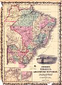
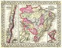
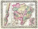
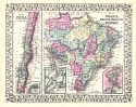
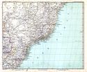
Main Author:
Johnson and Ward
Title/Description:
Johnson's Brazil, Argentine Republic, Paraquay, Uruguay
Publication Info:
[New York: Johnson and Ward, 1862?]
Date:
1862
Scale:
Original Source:
W. S. Hoole Special Collections Library
Viewing options:
JPEG
or
Plugin
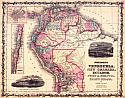
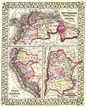
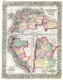
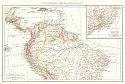
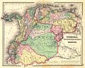
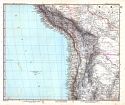
Main Author:
Johnson and Ward
Title/Description:
Johnson's Venezuela, New Granada, Ecuador, Peru & Bolivia, Chile and Guiana
Publication Info:
[New York: Johnson and Ward, 1862?]
Date:
1862
Scale:
Original Source:
W. S. Hoole Special Collections Library
Viewing options:
JPEG
or
Plugin
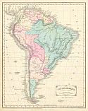
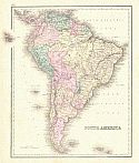
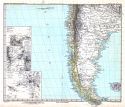
Main Author:
Wells, Edward
Title/Description:
South America
Publication Info:
New York: D. Appleton & Co.,1866; designed to accompany
Cornell's High School Geography
Date:
1866
Scale:
1:27,878,000
Original Source:
Courtesy of
Murray Hudson
, Halls, Tennessee
Viewing options:
JPEG
or
Plugin
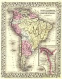
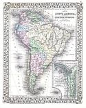
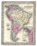
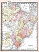
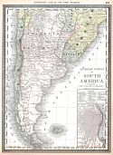
Main Author:
Mitchell Jr., S. Augustus
Title/Description:
Map of South America Showing Its Political Divisions
Publication Info:
Philadelphia: S. Augustus Mitchell, Jr., 1870
Date:
1870
Scale:
1:28,510,000
Original Source:
Rucker Agee Map Collection
Viewing options:
JPEG
or
Plugin
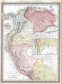
Main Author:
Mitchell Jr., S. Augustus
Title/Description:
Map of New Granada, Venezuela & Guiana; Map of Peru and Equador; Map of the Argentine Confederation
Publication Info:
Philadelphia: S. Augustus Mitchell, Jr., 1870
Date:
1870
Scale:
Various scales
Original Source:
Rucker Agee Map Collection
Viewing options:
JPEG
or
Plugin
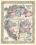
Main Author:
Mitchell Jr., S. Augustus
Title/Description:
Map of Chili; Map of Brazil, Bolivia, Paraguay and Uruguay
Publication Info:
Philadelphia: S. Augustus Mitchell, Jr., 1870
Date:
1870
Scale:
Various scales
Original Source:
Rucker Agee Map Collection
Viewing options:
JPEG
or
Plugin
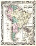
Main Author:
Mitchell, Samuel Augustus
Title/Description:
Map of South America Showing Its Political Divisons
Publication Info:
Philadelphia: S. Augustus Mitchell, 1874
Date:
1874
Scale:
1:28,500,000
Original Source:
Rucker Agee Map Collection
Viewing options:
JPEG
or
Plugin
Main Author:
Mitchell, Samuel Augustus
Title/Description:
Map of South America Showing Its Political Divisions
Publication Info:
Philadelphia: S. Augustus Mitchell, 1876
Date:
1876
Scale:
1:28,500,000
Original Source:
Rucker Agee Map Collection
Viewing options:
JPEG
or
Plugin
Main Author:
Mitchell, Samuel Augustus
Title/Description:
Map of New Granada, Venezuela & Guiana; Map of Peru and Equador; Map of the Argentine Confederation
Publication Info:
Philadelphia: S. Augustus Mitchell, 1876
Date:
1876
Scale:
Various scales
Original Source:
Rucker Agee Map Collection
Viewing options:
JPEG
or
Plugin
Main Author:
Mitchell, Samuel Augustus
Title/Description:
Map of Chili; Map of Brazil, Bolivia, Paraguay and Uruguay
Publication Info:
Philadelphia: S. Augustus Mitchell, 1876
Date:
1876
Scale:
Various scales
Original Source:
Rucker Agee Map Collection
Viewing options:
JPEG
or
Plugin
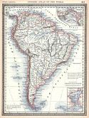
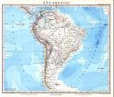
Main Author:
Gray, Ormando W.
Title/Description:
South America
Publication Info:
Philadelphia: O.W. Gray, 1876
Date:
1876
Scale:
1:22,176,000
Original Source:
Courtesy of
Murray Hudson
, Halls, Tennessee
Viewing options:
JPEG
or
Plugin
Main Author:
Hughes, W.
Title/Description:
South America
Publication Info:
London: George Philip and Son, [c. 1880]
Date:
1880
Scale:
1:30,000,000
Original Source:
Courtesy of Adams Antiques, Northport, Alabama
Viewing options:
JPEG
or
Plugin
Main Author:
Mitchell, Samuel Augustus
Title/Description:
Map of South America Showing Its Political Divisions
Publication Info:
Philadelphia: S. Augustus Mitchell, 1881
Date:
1881
Scale:
1:28,500,000
Original Source:
Rucker Agee Map Collection
Viewing options:
JPEG
or
Plugin
Main Author:
Mitchell, Samuel Augustus
Title/Description:
Map of Chili; Map of Brazil, Bolivia, Paraguay and Uruguay
Publication Info:
Philadelphia: S. Augustus Mitchell, 1881
Date:
1881
Scale:
Various scales
Original Source:
Rucker Agee Map Collection
Viewing options:
JPEG
or
Plugin
Main Author:
Mitchell, Samuel Augustus
Title/Description:
Map of New Granada, Venezuela & Guiana; Map of Peru and Equador; Map of the Argentine Confederation
Publication Info:
Philadelphia: S. Augustus Mitchell, 1881
Date:
1881
Scale:
Various scales
Original Source:
Rucker Agee Map Collection
Viewing options:
JPEG
or
Plugin
Main Author:
Andree, Richard
Title/Description:
Südamerika Nördliches Blatt
Publication Info:
Leipzig: Velhagen & Klasing, 1881; from Richard Andree's
Allegemeiner Handatlas
Date:
1881
Scale:
1:20,000,000
Original Source:
Courtesy of
Murray Hudson
, Halls, Tennessee
Viewing options:
JPEG
or
Plugin
Main Author:
Title/Description:
Brazil, Paraguay and Guayana
Publication Info:
Chicago: Rand McNally and Co., 1884; from
Rand McNally Indexed Atlas of the World
Date:
1884
Scale:
1:15,840,000
Original Source:
From the personal collection of Dr. Gerald Webster
Viewing options:
JPEG
or
Plugin
Main Author:
Title/Description:
Southern Portion of South America
Publication Info:
Chicago: Rand McNally and Co., 1884; from
Rand McNally Indexed Atlas of the World
Date:
1884
Scale:
1:12,000,000
Original Source:
From the personal collection of Dr. Gerald Webster
Viewing options:
JPEG
or
Plugin
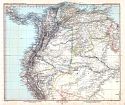
Main Author:
Title/Description:
Northwestern Portion of South America
Publication Info:
Chicago: Rand McNally and Co., 1884; from
Rand McNally Indexed Atlas of the World
Date:
1884
Scale:
1:11,400,000
Original Source:
From the personal collection of Dr. Gerald Webster
Viewing options:
JPEG
or
Plugin
Main Author:
Title/Description:
South America
Publication Info:
Chicago: Rand McNally and Co., 1884; from
Rand McNally Indexed Atlas of the World
Date:
1884
Scale:
1:27,250,000
Original Source:
From the personal collection of Dr. Gerald Webster
Viewing options:
JPEG
or
Plugin
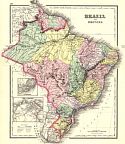
Main Author:
Title/Description:
Brazil and Guayana
Publication Info:
NY: G. Wand and C.B. Colton Co., 1886
Date:
1886
Scale:
1:12,670,000
Original Source:
Rucker Agee Map Collection
Viewing options:
JPEG
or
Plugin
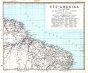
Main Author:
Title/Description:
Venezuela, United States of Columbia and Equador
Publication Info:
NY: G.W. and C.B. Colton Co., 1886
Date:
1886
Scale:
1:6,970,000
Original Source:
Rucker Agee Map Collection
Viewing options:
JPEG
or
Plugin
Main Author:
Stieler, Adolf
Title/Description:
Süd-Amerika
Publication Info:
Gotha: Justus Perthes, 1891; from his
Hand Atlas of 1891
Date:
1891
Scale:
1:25,000,000
Original Source:
Courtesy of Adams Antiques, Northport, Alabama
Viewing options:
JPEG
or
Plugin
Viewing options:
JPEG
or
Plugin
Viewing options:
JPEG
or
Plugin
Viewing options:
JPEG
or
Plugin
Viewing options:
JPEG
or
Plugin
Viewing options:
JPEG
or
Plugin
Viewing options:
JPEG
or
Plugin
Main Author:
Stieler, Adolf
Title/Description:
Süd-Amerika (maps 6 of 6)
Publication Info:
Gotha: Justus Perthes, 1891; from his
Hand Atlas of 1891
Date:
1891
Scale:
1:7,500,000
Original Source:
Courtesy of Adams Antiques, Northport, Alabama
Next Page