Next Page

  Main Author:   Bellin, Jacques Nicolas (info)
  Title/Description:   Carte de la Nouvelle Angleterre, Nouvelle Yorck, et Pensilvanie, pour servir L'Histoire Gnerale des Voyages
  Publication Info:   Paris: Didot, c.1757
  Date:   1757
  Scale:   1:3,485,000
  Original Source:   Courtesy of Murray Hudson, Halls, Tennessee
Viewing options:


  Main Author:   Homann, Johann Baptist (info)
  Title/Description:   Nova Anglia, Septentrionali Americæ implantata Anglorumque coloniis florentissima geographice exhibita â Ioh. Baptista Homann, sac. cæs. maj. geographo
  Publication Info:   Norimbergæ [Homann Erben, between 1759 and 1784]
  Date:   1759
  Scale:    
  Original Source:   W. S. Hoole Special Collections Library
Viewing options:


  Main Author:   Bonne, Rigobert (info)
  Title/Description:   Carte de la Partie Nord, des Etats Unis, de L'Amérique Septentrionale
  Publication Info:   Paris: Rigobert Bonne, c.1785
  Date:   1785
  Scale:   1:4,154,000
  Original Source:   Courtesy of Murray Hudson, Halls, Tennessee
Viewing options:


  Main Author:   Morse, Jedidiah
  Title/Description:   A Map of the District of Maine with New Brunsmick & Nova Scotia
  Publication Info:   Boston: Thomas & Andrews, 1796; Engraved for Morse's Universal Geography
  Date:   1796
  Scale:   1:3,675,000
  Original Source:   Courtesy of Murray Hudson, Halls, Tennessee
Viewing options:


  Main Author:   Botta, Carlo Guiseppe Guglielmo
  Title/Description:   Le Provincie Settentrionali degli Stati Uniti
  Publication Info:   Haly: c.1809
  Date:   1809
  Scale:   1:2,534,000
  Original Source:   Courtesy of Murray Hudson, Halls, Tennessee
Viewing options:


  Main Author:   unknown
  Title/Description:   The United States with Part of Canda
  Publication Info:   Philadelphia: Warner & Johnson, 1814
  Date:   1814
  Scale:   1:5,829,000
  Original Source:   Courtesy of Murray Hudson, Halls, Tennessee
Viewing options:


  Main Author:   Fenner, Sears, and Company
  Title/Description:   Map of Maine, New Hampshire and Vermont
  Publication Info:   London: I.T. Hinton & Simp-kin & Marshall, 1832
  Date:   1832
  Scale:   1:2,217,000
  Original Source:   Courtesy of Murray Hudson, Halls, Tennessee
Viewing options:


  Main Author:   Olney, Jesse
  Title/Description:   Middle States
  Publication Info:   New York: Robinson, Pratt and Company, 1837; from New and Improved School Atlas
  Date:   1837
  Scale:   1:2,851,000
  Original Source:   Courtesy of Murray Hudson, Halls, Tennessee
Viewing options:


  Main Author:   Olney, Jesse
  Title/Description:   Eastern States
  Publication Info:   New York: Robinson, Pratt and Company, 1837; from New and Improved School Atlas
  Date:   1837
  Scale:   1:2,471,000
  Original Source:   Courtesy of Murray Hudson, Halls, Tennessee
Viewing options:


  Main Author:   Evans, W. Gardner
  Title/Description:   The Middle States
  Publication Info:   New York: W. Gardner Evans, 1838
  Date:   1838
  Scale:   1:2,860,000
  Original Source:   Courtesy of Murray Hudson, Halls, Tennessee
Viewing options:


  Main Author:    
  Title/Description:   Map of Massachusetts, Connecticut, and Rhode Island constructed from the Latest Authorities
  Publication Info:   Hartford: Brown & Parsons, 1838
  Date:   1838
  Scale:   1:697,000
  Original Source:   Courtesy of Murray Hudson, Halls, Tennessee
Viewing options:


  Main Author:   Mitchell, Samuel Augustus
  Title/Description:   No. 7 Map of the Middle States and Part of the Southern
  Publication Info:   Philadelphia: S.A. Mitchell, 1839; Engraved to Illustrate Mitchell's School and Family Geography
  Date:   1839
  Scale:   1:2,851,000
  Original Source:   Courtesy of Murray Hudson, Halls, Tennessee
Viewing options:


  Main Author:   Mitchell, S. Augustus
  Title/Description:   No.6 Map of the New England or Eastern States
  Publication Info:   Philadelphia: Thomas, Cowperthwait and Company, 1839; from Mitchell's School Atlas
  Date:   1839
  Scale:   1:3,041,280
  Original Source:   Courtesy of Murray Hudson, Halls, Tennessee
Viewing options:


  Main Author:   Young, J.H.
  Title/Description:   No. 8 Map of the New England or Eastern States
  Publication Info:   Philadelphia: S.A. Mitchell, 1844; Engraved to Illustrate Mitchell's School and Family Geography
  Date:   1844
  Scale:   1:2,091,000
  Original Source:   Courtesy of Murray Hudson, Halls, Tennessee
Viewing options:


  Main Author:   Story & Atwood
  Title/Description:   Physical & Political Map of the N. Eastern States, adapted to Woodbridge's Geography
  Publication Info:   New York: Story & Atwood, 1845
  Date:   1845
  Scale:   1:4,752,000
  Original Source:   Courtesy of Murray Hudson, Halls, Tennessee
Viewing options:


  Main Author:   Society for the Diffusion of Useful Knowledge
  Title/Description:   North America Sheet VI New-York, Vermont, Maine, New-Hampshire, Massachusetts, Connecticut, Rhode-Island, and New-Jersey
  Publication Info:   London: Charles Knight & Co., 1846
  Date:   1846
  Scale:   1:1,774,000
  Original Source:   Courtesy of Murray Hudson, Halls, Tennessee
Viewing options:


  Main Author:   Cady and Burgess
  Title/Description:   Map No. 2 United States
  Publication Info:   Cady and Burgess, c.1847
  Date:   1847
  Scale:   1:1,584,000
  Original Source:   Courtesy of Murray Hudson, Halls, Tennessee
Viewing options:


  Main Author:   Mitchell, Samuel Augustus
  Title/Description:   Massachusetts, Rhode Island, and Connecticut
  Publication Info:   Philadelphia: S.A. Mitchell, 1851
  Date:   1851
  Scale:   1:1,837,000
  Original Source:   Courtesy of Murray Hudson, Halls, Tennessee
Viewing options:


  Main Author:   Mitchell, S.A.
  Title/Description:   New York, Pennsylvania, New Jersey, and Delaware
  Publication Info:   Philadelphia: S.A. Mitchell, 1851
  Date:   1851
  Scale:   1:3,168,000
  Original Source:   Courtesy of Murray Hudson, Halls, Tennessee
Viewing options:


  Main Author:   Mitchell, S.A.
  Title/Description:   Maine, New Hamshire, and Vermont
  Publication Info:   Philadelphia: S.A. Mitchell, 1851
  Date:   1851
  Scale:   1:3,168,000
  Original Source:   Courtesy of Murray Hudson, Halls, Tennessee
Viewing options:


  Main Author:   Burgess, Daniel
  Title/Description:   Map No. 3 United States
  Publication Info:   New York: Daniel Burgess, 1854
  Date:   1854
  Scale:   1:3,168,000
  Original Source:   Courtesy of Murray Hudson, Halls, Tennessee
Viewing options:


  Main Author:   Cornell, Sarah Sophie
  Title/Description:   Northern or Middle States
  Publication Info:   New York: D. Appleton & Co., 1855; designed to accompany Cornell's High School Geography
  Date:   1855
  Scale:   1:3,041,000
  Original Source:   Courtesy of Murray Hudson, Halls, Tennessee
Viewing options:


  Main Author:   Cornell, Sarah Sophia
  Title/Description:   Eastern Division of the United States
  Publication Info:   New York: D. Appleton & Co.,1855; Designed to Accompany Cornell's High School Geography
  Date:   1855
  Scale:   1:2,851,000
  Original Source:   W. S. Hoole Special Collections Library
Viewing options:


  Main Author:   Cornell, Sarah Sophia
  Title/Description:   New England or Eastern States
  Publication Info:   New York: D. Appleton & Co.,1855; Designed to Accompany Cornell's High School Geography
  Date:   1855
  Scale:   1:2,725,000
  Original Source:   W. S. Hoole Special Collections Library
Viewing options:


  Main Author:   Smith, Roswell C.
  Title/Description:   Map No.1, United States (Vermont, New Hampshire and Maine)
  Publication Info:   New York: Daniel Burgess and Company, 1855; from A Concise and Practical System of Geography for Schools, Academies and Families
  Date:   1855
  Scale:   1:2,661,200
  Original Source:   Courtesy of Murray Hudson, Halls, Tennessee
Viewing options:


  Main Author:   Smith, Roswell C.
  Title/Description:   Map No.2, United States (Massachusetts, Connecticut and Rhode Island)
  Publication Info:   New York: Daniel Burgess and Company, 1855; from A Concise and Practical System of Geography for Schools, Academies and Families
  Date:   1855
  Scale:   1:1,584,000
  Original Source:   Courtesy of Murray Hudson, Halls, Tennessee
Viewing options:


  Main Author:   Smith, Roswell C.
  Title/Description:   Map No.3, United States (New York, Pennsylvania and New Jersey)
  Publication Info:   New York: Daniel Burgess and Company, 1855; from A Concise and Practical System of Geography for Schools, Academies and Families
  Date:   1855
  Scale:   1:3,168,000
  Original Source:   Courtesy of Murray Hudson, Halls, Tennessee
Viewing options:


  Main Author:   Wells, E.
  Title/Description:   N. Eastern Division of the United States
  Publication Info:   New York: D. Appleton and Co., c.1857; Designed to Accompany Cornell's High School Geography
  Date:   1857
  Scale:   1:2,218,000
  Original Source:   Courtesy of Murray Hudson, Halls, Tennessee
Viewing options:


  Main Author:   Bartholomew, J.
  Title/Description:   New York, Vermont, New Hampshire, Rhode Island, Massachusetts and Connecticut
  Publication Info:   Edinburgh: A. and C. Black c. 1857
  Date:   1857
  Scale:   1: 1,584,000
  Original Source:   University of Alabama Map Library
Viewing options:


  Main Author:   Williams, W.
  Title/Description:   County Map of the States of New York, New Hampshire, Vermont, Massachusetts, Rhode Id., and Connecticut
  Publication Info:   Philadelphia: S.A. Mitchell, 1860
  Date:   1860
  Scale:   1:1,901,000
  Original Source:   Courtesy of Murray Hudson, Halls, Tennessee
Viewing options:


  Main Author:   Sandoz, Ernest
  Title/Description:   Physikalische Karte Alleghany - Systems
  Publication Info:   Gotha: Justus Perthes, 1860; from Petermann's Geographische Mittheilungen
  Date:   1860
  Scale:   1:6,000,000
  Original Source:   Courtesy of Murray Hudson, Halls, Tennessee
Viewing options:


  Main Author:   Boynton, G.W.
  Title/Description:   New Jersey, Pennsylvania, Delaware, and Maryland
  Publication Info:   Boston: G.W. Boynton, 1860
  Date:   1860
  Scale:   1:4,118,000
  Original Source:   Courtesy of Murray Hudson, Halls, Tennessee
Viewing options:


  Main Author:   Wells, J.
  Title/Description:   New England & Middle States
  Publication Info:   New York: S.F. Baker, c.1860
  Date:   1860
  Scale:   1:4,435,000
  Original Source:   Courtesy of Murray Hudson, Halls, Tennessee
Viewing options:


  Main Author:   Mitchell, Samuel Augustus
  Title/Description:   County Map of Pennsylvania, New Jersey, Maryland, and Delaware
  Publication Info:   Philadelphia: S.A. Mitchell, 1861
  Date:   1861
  Scale:   1:2,091,000
  Original Source:   Courtesy of Murray Hudson, Halls, Tennessee
Viewing options:


  Main Author:   Johnson, A.J.
  Title/Description:   Johnson's New England
  Publication Info:   New York: Johnson and Browning, 1862
  Date:   1862
  Scale:   1:1,584,000
  Original Source:   Courtesy of Murray Hudson, Halls, Tennessee
Viewing options:


  Main Author:   Johnson and Ward
  Title/Description:   Johnson's Massachusetts, Connecticut, and Rhode Island
  Publication Info:   New York: Johnson and Ward, 1862
  Date:   1862
  Scale:   1:570,000
  Original Source:   Courtesy of Murray Hudson, Halls, Tennessee
Viewing options:


  Main Author:   Gamble, W.H.
  Title/Description:   County Map of Massachusetts, Connecticut, and Rhode Island
  Publication Info:   Philadelphia: S.A. Mitchell, c.1863
  Date:   1863
  Scale:   1:950,000
  Original Source:   Courtesy of Murray Hudson, Halls, Tennessee
Viewing options:


  Main Author:   Johnson, A.J.
  Title/Description:   Johnson's Vermont, New Hampshire, Massachusetts, Rhode Island, and Connecticut
  Publication Info:   New York: Johnson and Ward, 1864
  Date:   1864
  Scale:   1:1,109,000
  Original Source:   Courtesy of Murray Hudson, Halls, Tennessee
Viewing options:


  Main Author:   Johnson, A.J.
  Title/Description:   Johnson's Massachusetts, Connecticut and Rhode Island
  Publication Info:   New York: Johnson and Ward, 1864; from Johnson's New Illustrated Family Atlas
  Date:   1864
  Scale:   1:570,000
  Original Source:   Courtesy of Murray Hudson, Halls, Tennessee
Viewing options:


  Main Author:   Calvin, Smith, & Tanner
  Title/Description:   
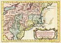
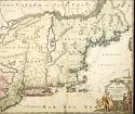
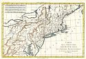
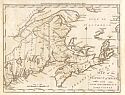
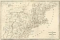
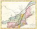
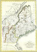
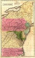
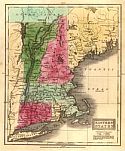
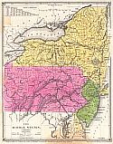
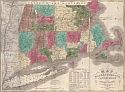
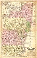
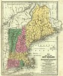
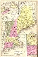
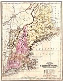
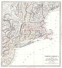
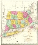
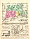
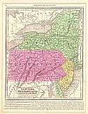
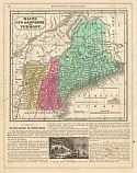
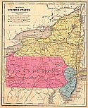
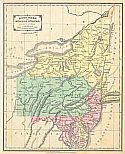
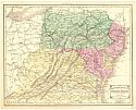
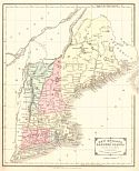
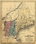
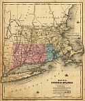
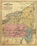
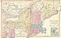
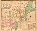
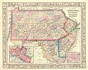
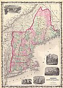
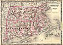
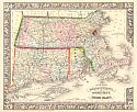
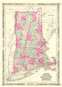
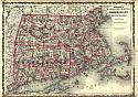
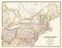
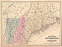
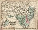
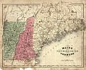
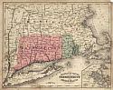
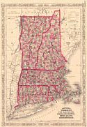
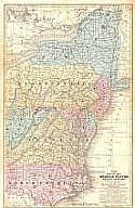
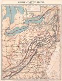
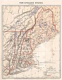
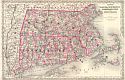
United States North America Sheet LVI. The North Eastern States Comprising Maine, New Hampshire, Rhode Island, Connecticut, New Jersey, Delaware, Pennsylvania, Maryland, Ohio, and Part of Virginia and Michigan
  Publication Info:   Edinburgh: A. Fullarton & Co., c.1865
  Date:   1865
  Scale:   1:2,841,000
  Original Source:   Courtesy of Murray Hudson, Halls, Tennessee
Viewing options:


  Main Author:   Cornell, Sarah Sophia
  Title/Description:   Maine, New Hampshire, and Vermont (VIII)
  Publication Info:   New York: D. Appleton & Co., c.1865
  Date:   1865
  Scale:   1:2,091,000
  Original Source:   Courtesy of Murray Hudson, Halls, Tennessee
Viewing options:


  Main Author:   McNally, Francis
  Title/Description:   New Jersey, Pennsylvania, Delaware and Maryland
  Publication Info:   New York: A.S. Barnes and Burr, 1865; from An Improved System of Geography
  Date:   1865
  Scale:   1:2,407,680
  Original Source:   Courtesy of Murray Hudson, Halls, Tennessee
Viewing options:


  Main Author:   McNally, Francis
  Title/Description:   Maine, New Hampshire, Vermont
  Publication Info:   New York: A.S. Barnes and Burr, 1865; from An Improved System of Geography
  Date:   1865
  Scale:   1:1,900,800
  Original Source:   Courtesy of Murray Hudson, Halls, Tennessee
Viewing options:


  Main Author:   McNally, Francis
  Title/Description:   Massachusetts, Connecticut and Rhode Island
  Publication Info:   New York: A.S. Barnes and Burr, 1865; from An Improved System of Geography
  Date:   1865
  Scale:   1:1,330,560
  Original Source:   Courtesy of Murray Hudson, Halls, Tennessee
Viewing options:


  Main Author:   Johnson, A.J.
  Title/Description:   Johnson's Vermont, New Hampshire, Massachusetts, Rhode Island, and Connecticut
  Publication Info:   New York: A.J. Johnson, 1866
  Date:   1866
  Scale:   1:1,109,000
  Original Source:   Courtesy of Murray Hudson, Halls, Tennessee
Viewing options:


  Main Author:   Mitchell, Samuel Augustus
  Title/Description:   No. 10 Map of the Middle States and Part of the Southern
  Publication Info:   Philadelphia: S.A. Mitchell, 1866; Engraved to Illustrate Mitchell's School and Family Geography
  Date:   1866
  Scale:   1:2,851,000
  Original Source:   Courtesy of Murray Hudson, Halls, Tennessee
Viewing options:


  Main Author:   Guyot, A.
  Title/Description:   Middle Atlantic States
  Publication Info:   NewYork: Charles Scribner & Company, 1868; from Guyot's Common-School Geography
  Date:   1868
  Scale:   1:4,435,000
  Original Source:   University of Alabama Map Library
Viewing options:


  Main Author:   Guyot, A.
  Title/Description:   New England States
  Publication Info:   NewYork: Charles Scribner & Company, 1868; from Guyot's Common-School Geography
  Date:   1868
  Scale:   1:3,295,000
  Original Source:   University of Alabama Map Library
Viewing options:


  Main Author:   Colton, G.W. and C.B. Colton
  Title/Description:   Colton's Massachusetts, Connecticut, and Rhode Island
  Publication Info:   New York: G.W. Colton and C.B. Colton, 1869
  Date:   1869
  Scale:   1:570,000
  Original Source:   Courtesy of Murray Hudson, Halls, Tennessee
Viewing options:
 

Next Page