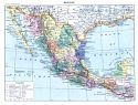
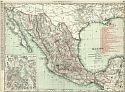
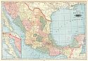
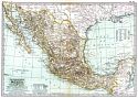
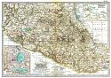
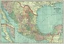
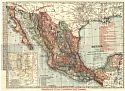
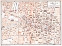
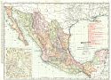
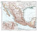
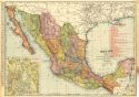
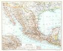
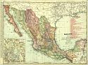
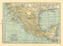
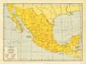
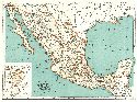
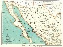
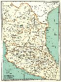
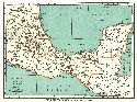
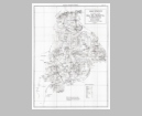
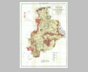
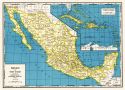
Home  |  Help  |  Graphics Tutorial  |  Aerial Photography  |  Historical Maps  |  Contemporary Maps  |  About this site  | 


After 1900
Before 1850
1850-1900
After 1900

Previous Page

  Main Author:    
  Title/Description:   Mexique
  Publication Info:   Paris: [c. 1901]; from Nouveau Larousse Illustré., Claude Auge, ed.
  Date:   1901
  Scale:   1:10,000,000
  Original Source:   Courtesy of Adams Antiques, Northport, Alabama
Viewing options:


  Main Author:   Rand McNally and Company
  Title/Description:   Mexico
  Publication Info:   Chicago: Rand McNally and Company, 1901; from The Enlarged Business Atlas and Shippers Guide
  Date:   1901
  Scale:   1:4,561,920
  Original Source:   Courtesy of Murray Hudson, Halls, Tennessee
Viewing options:


  Main Author:   Tunison, Henry Cuthbert
  Title/Description:   Mexico
  Publication Info:   New York: H.C. Tunison, 1901; from Tunison's Atlas, Encyclopædia, Gazetteer, and Portfolio of Our Universe, Globe, and Nation
  Date:   1901
  Scale:   1:5,385,600
  Original Source:   University of Alabama Map Library
Viewing options:


  Main Author:   The Century Company
  Title/Description:   Mexico
  Publication Info:   Buffalo: The Matthews-Northrup Company, 1902; from The Century Atlas
  Date:   1902
  Scale:   1:7,920,000
  Original Source:   From the personal collection of Dr. Robert Burckhalter
Viewing options:


  Main Author:   The Century Company
  Title/Description:   Mexico, Central Portion
  Publication Info:   Buffalo: The Matthews-Northrup Company, 1902; from The Century Atlas
  Date:   1902
  Scale:   1:3,168,000
  Original Source:   From the personal collection of Dr. Robert Burckhalter
Viewing options:


  Main Author:   Cram, George F.
  Title/Description:   Map of Mexico
  Publication Info:   Chicago: George F. Cram, 1903; from The Modern Atlas
  Date:   1903
  Scale:   1:5,068,800
  Original Source:   Courtesy of Murray Hudson, Halls, Tennessee
Viewing options:


  Main Author:   Greene Consolidated Gold Company
  Title/Description:   Mexico
  Publication Info:   New York: Greene Consolidated Gold Company, 1904
  Date:   1904
  Scale:   1:4,561,920
  Original Source:   Courtesy of Murray Hudson, Halls, Tennessee
Viewing options:


  Main Author:   Baedeker, Karl
  Title/Description:   México (City)
  Publication Info:   Leipzig: Karl Baedeker, 1904; from The United States with an Excursion to Mexico
  Date:   1904
  Scale:   1:20,000
  Original Source:   University of Alabama Map Library
Viewing options:


  Main Author:   Rand McNally and Company
  Title/Description:   Mexico
  Publication Info:   Chicago: Rand McNally and Company, 1905; from The Enlarged Business Atlas and Shippers Guide
  Date:   1905
  Scale:   1:4,561,920
  Original Source:   Courtesy of Murray Hudson, Halls, Tennessee
Viewing options:


  Main Author:   Habenicht, H.
  Title/Description:   Mexico, Guatemala und Salvador
  Publication Info:   Gotha: Justus Perthes, 1905; from Stielers Hand-Atlas
  Date:   1905
  Scale:   1:7,500,000
  Original Source:   Courtesy of Adams Antiques, Northport, Alabama
Viewing options:


  Main Author:   Rand McNally and Company
  Title/Description:   Mexico
  Publication Info:   Chicago: Rand McNally and Company, 1905; from Indexed Atlas of the World
  Date:   1905
  Scale:   1:4,561,920
  Original Source:   University of Alabama Map Library
Viewing options:


  Main Author:   Meyer, Joseph
  Title/Description:   Mexiko
  Publication Info:   Leipzig: Bibliographisches Institut, 1906; from Konverlations - Lexikon
  Date:   1906
  Scale:   1:12,000,000
  Original Source:   Courtesy of Adams Antiques, Northport, Alabama
Viewing options:


  Main Author:   Rand McNally and Company
  Title/Description:   Mexico
  Publication Info:   Chicago: Rand McNally and Company, 1906; from The Business Atlas and Shippers Guide
  Date:   1906
  Scale:   1:4,561,920
  Original Source:   Courtesy of Murray Hudson, Halls, Tennessee
Viewing options:


  Main Author:   Instituto Geologico de Mexico
  Title/Description:   Croquis Geologico del Ex-Distrito de Mazatlan, Estado de Sinaloa
  Publication Info:   Mexico City: Instituto Geologico de Mexico, 1920
  Date:   1920
  Scale:   1:196,850
  Original Source:   Geological Survey of Alabama
Viewing options:


  Main Author:   Instituto Geologico de Mexico
  Title/Description:   Mapa Geologico del Ex-Distrito de San Ignacio
  Publication Info:   Mexico City: Instituto Geologico de Mexico, 1920
  Date:   1920
  Scale:   1:196,850
  Original Source:   Geological Survey of Alabama
Viewing options:


  Main Author:   Instituto Geologico de Mexico
  Title/Description:   Croquis Geologico del Ex-Distrito de Concordia, Estado de Sinaloa
  Publication Info:   Mexico City: Instituto Geologico de Mexico, 1920
  Date:   1920
  Scale:   1:200,000
  Original Source:   Geological Survey of Alabama
Viewing options:


  Main Author:   Funk and Wagnalls Company
  Title/Description:   Mexico
  Publication Info:   New York: Funk and Wagnalls Company, 1923; from Atlas of the World and Gazetteer
  Date:   1923
  Scale:   1:19,000,000
  Original Source:   University of Alabama Map Library
Viewing options:


  Main Author:   C.S. Hammond and Company
  Title/Description:   Economic Map of Mexico
  Publication Info:   New York: C.S. Hammond and Company, c. 1930; from The New World Loose Leaf Atlas, Sixth Edition
  Date:   1930
  Scale:   1:11,400,000
  Original Source:   University of Alabama Map Library
Viewing options:


  Main Author:   Rand McNally and Company
  Title/Description:   Popular Map of Mexico
  Publication Info:   Chicago: Rand McNally and Company, 1936
  Date:   1936
  Scale:   1:9,833,000
  Original Source:   University of Alabama Map Library
Viewing options:


  Main Author:   Rand McNally and Company
  Title/Description:   Popular Map of Mexico, Western Part
  Publication Info:   Chicago: Rand McNally and Company, 1936
  Date:   1936
  Scale:   1:5,000,000
  Original Source:   University of Alabama Map Library
Viewing options:


  Main Author:   Rand McNally and Company
  Title/Description:   Popular Map of Mexico, Central Part
  Publication Info:   Chicago: Rand McNally and Company, 1936
  Date:   1936
  Scale:   1:5,000,000
  Original Source:   University of Alabama Map Library
Viewing options:


  Main Author:   Rand McNally and Company
  Title/Description:   Popular Map of Mexico, Eastern Part
  Publication Info:   Chicago: Rand McNally and Company, 1936
  Date:   1936
  Scale:   1:5,000,000
  Original Source:   University of Alabama Map Library
Viewing options:


  Main Author:   Instituto Geologico de Mexico
  Title/Description:   Croquis Topografico de la Region Llamada, Valle del Mezquital, Estado de Hidalgo
  Publication Info:   Mexico City: Instituto Geologico de Mexico, 1937
  Date:   1937
  Scale:   1:200,000
  Original Source:   Geological Survey of Alabama
Viewing options:


  Main Author:   Instituto Geologico de Mexico
  Title/Description:   Croquis Geologico de la Region Llamada, Valle del Mezquital, Estado de Hidalgo
  Publication Info:   Mexico City: Instituto Geologico de Mexico, 1937
  Date:   1937
  Scale:   1:200,000
  Original Source:   Geological Survey of Alabama
Viewing options:


  Main Author:   Geographical Publishing Company
  Title/Description:   Mexico and West Indies
  Publication Info:   Chicago: Geographical Publishing Company, 1942; from The New International Atlas of the World, War Edition
  Date:   1942
  Scale:   1:15,206,000
  Original Source:   University of Alabama Map Library
Viewing options:


  Main Author:   Humble Oil and Refining Company
  Title/Description:   Road Map of Mexico
  Publication Info:   New York: General Drafting Company, 1946
  Date:   1946
  Scale:   1:6,336,000
  Original Source:   Murray Hudson
Viewing options:


  Main Author:   U.S. Geological Survey
  Title/Description:   Geologic Map and Structure Section of the Lucifer Manganese District, Baja California, Mexico
  Publication Info:   Washington: Department of the Interior, U.S. Geological Survey, 1948; Bulletin 960-F Plate 39
  Date:   1948
  Scale:   1:19,680
  Original Source:   Geological Survey of Alabama
Viewing options:


  Main Author:   U.S. Geological Survey
  Title/Description:   Geological Map and Structure Sections of the Santa Clara Coal District, Sonora, Mexico
  Publication Info:   Washington: Department of the Interior, U.S. Geological Survey, 1950; Bulletin 962-A Plate 2
  Date:   1950
  Scale:   1:7,800
  Original Source:   Geological Survey of Alabama
Viewing options:


  Main Author:   U.S. Geological Survey
  Title/Description:   Geologic Map of the Canoas Quicksilver District, State of Zacatecas, Mexico
  Publication Info:   Washington: Department of the Interior, U.S. Geological Survey, 1952; Bulletin 975-B Plate 7
  Date:   1952
  Scale:   1:10,000
  Original Source:   Geological Survey of Alabama
Viewing options:


  Main Author:   U.S. Geological Survey
  Title/Description:   Topographic Map of Paricutin Volcano and Vicinity, Three Years After the Volcano's Birth
  Publication Info:   Washington: Department of the Interior, U.S. Geological Survey, 1954; Bulletin 965-C Plate 13
  Date:   1954
  Scale:   1:10,000
  Original Source:   Geological Survey of Alabama
Viewing options:


  Main Author:   U.S. Geological Survey
  Title/Description:   Geologic Map and Structure Sections of the Concepcion del Oro District, Zacatecas, Mexico
  Publication Info:   Washington: Department of the Interior, U.S. Geological Survey, 1956; Bulletin 1037-A Plate 1
  Date:   1956
  Scale:   1:50,000
  Original Source:   Geological Survey of Alabama
Viewing options:


  Main Author:   U.S. Geological Survey
  Title/Description:   Reconnaissance Geologic Map and Section of the Bernal-Jalpan Area, Queretaro, Mexico
  Publication Info:   Washington: Department of the Interior, U.S. Geological Survey, 1961; Bulletin 1104-B Plate 2
  Date:   1961
  Scale:   1:190,080
  Original Source:   Geological Survey of Alabama
Viewing options:


  Main Author:   U.S. Geological Survey
  Title/Description:   Geologic Map and Sections of the South-Central Hildago and Northeastern Mexico, Mexico
  Publication Info:   Washington: Department of the Interior, U.S. Geological Survey, 1962; Bulletin 1104-G Plate 3
  Date:   1962
  Scale:   1:190,080
  Original Source:   Geological Survey of Alabama
Viewing options: