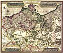
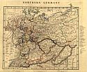
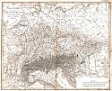
Home  |  Help  |  Graphics Tutorial  |  Aerial Photography  |  Historical Maps  |  Contemporary Maps  |  About this site  | 


Before 1850
Before 1850
1850-1875
1876-1900
After 1900

Next Page

  Main Author:   Visscher, Claes Jansz
  Title/Description:   Tabula Electoratus Brandenburgici, Mecklenburgi, et Maximae partis Pomeraniae
  Publication Info:   S.l.: s.n., 1633
  Date:   1633
  Scale:   1:940,000
  Original Source:   W. S. Hoole Special Collections Library
Viewing options:


  Main Author:   Hondius, Hendrick (info)
  Title/Description:   Germaniae Nova et Accurata Delineatio
  Publication Info:   Amsterdam: 1636
  Date:   1636
  Scale:   1:3,230,000
  Original Source:   W. S. Hoole Special Collections Library
Viewing options:


  Main Author:   Blaeu, Willem Janszoon (info)
  Title/Description:   Brandeburgum Marchionatus, cum Ducatibus Pomeraniae et Mekelenburgi
  Publication Info:   [Amsterdam: c. 1650]
  Date:   1650
  Scale:   1:690,000
  Original Source:   W. S. Hoole Special Collections Library
Viewing options:


  Main Author:    
  Title/Description:   Albis, fluvis, Germaniae celebris, a fontibus ad Ostia, cum fluminibus ab utroque latere in illum, descriptus [tabula].
  Publication Info:   Amstelodami: Apud Ioannem Ianssonium, 1658?
  Date:   1658
  Scale:    
  Original Source:   W. S. Hoole Special Collections Library
Viewing options:


  Main Author:   Wells, Edward (info)
  Title/Description:   A New Map of Antient Germany, Rhaetia, Vindelicia and Noricum
  Publication Info:   [London: 1718]
  Date:   1718
  Scale:   1:3,800,000
  Original Source:   Rucker Agee Map Collection
Viewing options:


  Main Author:   Wells, Edward (info)
  Title/Description:   A New Map of Present Germany
  Publication Info:   [London: 1718]
  Date:   1718
  Scale:   1:2,850,000
  Original Source:   Rucker Agee Map Collection
Viewing options:


  Main Author:   Senex, John (info)
  Title/Description:   The Empire of Germany: divided into its general and particular parts
  Publication Info:   London: D. Browne, 1721
  Date:   1721
  Scale:   1:1,900,000
  Original Source:   W. S. Hoole Special Collections Library
Viewing options:


  Main Author:   Moll, Herman (info)
  Title/Description:   Germany Divided into Circles Agreeable to Modern History
  Publication Info:   London: Herman Moll, 1732
  Date:   1732
  Scale:   1:5,700,000
  Original Source:   Courtesy of Murray Hudson, Halls, Tennessee
Viewing options:


  Main Author:    
  Title/Description:   L'Empire D'Allemagne
  Publication Info:   Paris: Buffier, 1744
  Date:   1744
  Scale:   1:8,870,000
  Original Source:   Courtesy of Murray Hudson, Halls, Tennessee
Viewing options:


  Main Author:   de Vaugondy, Giles Robert (info)
  Title/Description:   Allemagne divisée par Cercles
  Publication Info:   Paris: 1750
  Date:   1750
  Scale:   1:7,190,000
  Original Source:   Courtesy of Murray Hudson, Halls, Tennessee
Viewing options:


  Main Author:    
  Title/Description:   A Map of Bohemia, Moravia, Silesia, Lussatia, with great part of Saxony and Brandenburg; Showing the Present Seat of War, in Germany
  Publication Info:   London: Gentleman's Magazine, 1756; published according to Act of Parliment, Dec. 1, 1756
  Date:   1756
  Scale:   1:2,218,000
  Original Source:   Courtesy of Murray Hudson, Halls, Tennessee
Viewing options:


  Main Author:   Jefferys, Thomas (info)
  Title/Description:   Germany
  Publication Info:   London: Thomas Jefferys, 1763
  Date:   1763
  Scale:   1:6,336,000
  Original Source:   Courtesy of Murray Hudson, Halls, Tennessee
Viewing options:


  Main Author:   Cellarius, Christophorus
  Title/Description:   Germania Antiqua
  Publication Info:   Rome: J.B. Ghisi, 1774; from Cellarius' Geographica Antiqua in Compendium Redacta
  Date:   1774
  Scale:   1:4,077,000
  Original Source:   Courtesy of Murray Hudson, Halls, Tennessee
Viewing options:


  Main Author:   Bowen, Thomas (info)
  Title/Description:   A New Map of the Empire of Germany, from the latest Improvements and Regulated by Astronomical Observations
  Publication Info:   London: Thomas Bowen, 1778; Engraved for Middleton's Complete System of Geography
  Date:   1778
  Scale:   1:6,572,000
  Original Source:   Courtesy of Murray Hudson, Halls, Tennessee
Viewing options:


  Main Author:    
  Title/Description:   Germany from the Best Authorities
  Publication Info:   London: c.1789
  Date:   1789
  Scale:   1:6,970,000
  Original Source:   Courtesy of Murray Hudson, Halls, Tennessee
Viewing options:


  Main Author:   Kitchin, Thomas (info)
  Title/Description:   Germany and the Netherlands from the latest Authorities
  Publication Info:   London: Thomas Kitchin, 1790
  Date:   1790
  Scale:   1:5,956,000
  Original Source:   Courtesy of Murray Hudson, Halls, Tennessee
Viewing options:


  Main Author:   Kitchin, Thomas (info)
  Title/Description:   Germany and the Netherlands from the latest Authorities
  Publication Info:   London: C. Dilly & G.G.J. and J. Robinson, 1790; from Guthrie's A new Geographical, Historical, and Commerical Grammer; and Present State of Several Kingdoms of the World
  Date:   1790
  Scale:   1:5,956,000
  Original Source:   Courtesy of Murray Hudson, Halls, Tennessee
Viewing options:


  Main Author:    
  Title/Description:   A New Map of Germany Divided into Circles from the Best Authorities
  Publication Info:   London: c.1795
  Date:   1795
  Scale:   1:5,069,000
  Original Source:   Courtesy of Murray Hudson, Halls, Tennessee
Viewing options:


  Main Author:    
  Title/Description:   Germany; from the Best Authorities
  Publication Info:   Siffolk: C. Brightly & J. Kinnersly, 1807
  Date:   1807
  Scale:   1:6,970,000
  Original Source:   Courtesy of Murray Hudson, Halls, Tennessee
Viewing options:


  Main Author:   Streit, Friedrich Wilhelm
  Title/Description:   General-Charte van Teutschland
  Publication Info:   Weimar: Verlag des Geographischen Instituts, 1810
  Date:   1810
  Scale:   1:1,014,000
  Original Source:   Courtesy of Murray Hudson, Halls, Tennessee
Viewing options:


  Main Author:   Pinkerton, John
  Title/Description:   Germany- South of the Mayn
  Publication Info:   London: Cadell and Davies, Strand and Longman, 1815; from Pinkertons Modern Atlas
  Date:   1815
  Scale:   1: 887,000
  Original Source:   University of Alabama Map Library
Viewing options:


  Main Author:   Pinkerton, John
  Title/Description:   Germany- North of the Mayn
  Publication Info:   London: Cadell and Davies, Strand and Longman, 1815; from Pinkertons Modern Atlas
  Date:   1815
  Scale:   1: 1,140,000
  Original Source:   University of Alabama Map Library
Viewing options:


  Main Author:    
  Title/Description:   N.W. & N.E. Parts of Germany
  Publication Info:   Edinburgh: W. Sommerville, A. Fullerton, J. Blackie & Co., 1819; from the Glasgow Geography
  Date:   1819
  Scale:   1:3,732
  Original Source:   Courtesy of Murray Hudson, Halls, Tennessee
Viewing options:


  Main Author:   Butler, Samuel
  Title/Description:   Germany and Prussia
  Publication Info:   London: Longman and Company, 1820; from an Atlas of Modern Geography
  Date:   1820
  Scale:   1:6,336,000
  Original Source:   Courtesy of Adams Antiques, Northport, Alabama
Viewing options:


  Main Author:   Bradley, J.
  Title/Description:   Germany
  Publication Info:   London: [J. Bradley], 1820; for J. Bradley's Elements of Geography
  Date:   1820
  Scale:   1:7,603,200
  Original Source:   University of Alabama Map Library
Viewing options:


  Main Author:   Malte-Brun, M.
  Title/Description:   Germany and Switerland
  Publication Info:   Philadelphia: John Grigg, 1828; from A New General Atlas, Exhibiting the Five Great Divisions of the Globe
  Date:   1828
  Scale:   1:5,700,000
  Original Source:   Courtesy of Murray Hudson, Halls, Tennessee
Viewing options:


Main Author:   Arrowsmith, A.
Titles/Descriptions:   "Northern Germany" and "Germania"
Publication Info:   London: A. Arrowsmith, 1828; from a Comparative Atlas of Ancient and Modern Geography
Date:   1828
Scale:   1: 4,752,000
Original Source:   University of Alabama Map Library
Modern
Ancient
Viewing options:
Viewing options:
JPEG or Plugin
JPEG or Plugin


Main Author:   Arrowsmith, A.
Titles/Descriptions:   "Southern Germany" and "Vindelicia, Noricum, Rhaetia, Pannonia, et Illyricum"
Publication Info:   London: A. Arrowsmith, 1828; from a Comparative Atlas of Ancient and Modern Geography
Date:   1828
Scale:   1: 3,674,880
Original Source:   University of Alabama Map Library
Modern
Ancient
Viewing options:
Viewing options:
JPEG or Plugin
JPEG or Plugin


  Main Author:   Finley, Anthony