Before 1850
1850-1890
After 1890
Next Page

  Main Author:   Visscher, Claes Jansz
  Title/Description:   Tabula Electoratus Brandenburgici, Mecklenburgi, et Maximae partis Pomeraniae
  Publication Info:   S.l.: s.n., 1633
  Date:   1633
  Scale:   1:940,000
  Original Source:   W. S. Hoole Special Collections Library
Viewing options:


  Main Author:   Hondius, Hendrick (info)
  Title/Description:   Germaniae Nova et Accurata Delineatio
  Publication Info:   Amsterdam: 1636
  Date:   1636
  Scale:   1:3,230,000
  Original Source:   W. S. Hoole Special Collections Library
Viewing options:


  Main Author:   Blaeu, Willem Janszoon (info)
  Title/Description:   Brandeburgum Marchionatus, cum Ducatibus Pomeraniae et Mekelenburgi
  Publication Info:   [Amsterdam: c. 1650]
  Date:   1650
  Scale:   1:690,000
  Original Source:   W. S. Hoole Special Collections Library
Viewing options:


  Main Author:    
  Title/Description:   Albis, fluvis, Germaniae celebris, a fontibus ad Ostia, cum fluminibus ab utroque latere in illum, descriptus [tabula].
  Publication Info:   Amstelodami: Apud Ioannem Ianssonium, 1658?
  Date:   1658
  Scale:    
  Original Source:   W. S. Hoole Special Collections Library
Viewing options:


  Main Author:   Wells, Edward (info)
  Title/Description:   A New Map of Antient Germany, Rhaetia, Vindelicia and Noricum
  Publication Info:   [London: 1718]
  Date:   1718
  Scale:   1:3,800,000
  Original Source:   Rucker Agee Map Collection
Viewing options:


  Main Author:   Wells, Edward (info)
  Title/Description:   A New Map of Present Germany
  Publication Info:   [London: 1718]
  Date:   1718
  Scale:   1:2,850,000
  Original Source:   Rucker Agee Map Collection
Viewing options:


  Main Author:   Senex, John (info)
  Title/Description:   The Empire of Germany: divided into its general and particular parts
  Publication Info:   London: D. Browne, 1721
  Date:   1721
  Scale:   1:1,900,000
  Original Source:   W. S. Hoole Special Collections Library
Viewing options:


  Main Author:   Moll, Herman (info)
  Title/Description:   Germany Divided into Circles Agreeable to Modern History
  Publication Info:   London: Herman Moll, 1732
  Date:   1732
  Scale:   1:5,700,000
  Original Source:   Courtesy of Murray Hudson, Halls, Tennessee
Viewing options:


  Main Author:    
  Title/Description:   L'Empire D'Allemagne
  Publication Info:   Paris: Buffier, 1744
  Date:   1744
  Scale:   1:8,870,000
  Original Source:   Courtesy of Murray Hudson, Halls, Tennessee
Viewing options:


  Main Author:   de Vaugondy, Giles Robert (info)
  Title/Description:   Allemagne divisée par Cercles
  Publication Info:   Paris: 1750
  Date:   1750
  Scale:   1:7,190,000
  Original Source:   Courtesy of Murray Hudson, Halls, Tennessee
Viewing options:


  Main Author:    
  Title/Description:   
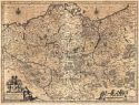
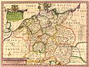
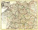
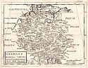
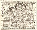
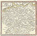
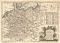
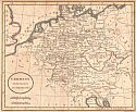
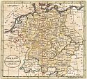
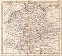
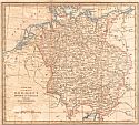
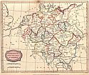
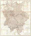
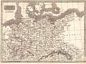
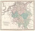
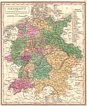
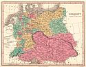
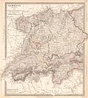
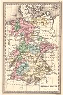
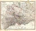
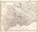
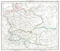
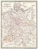
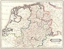
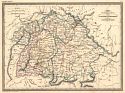
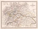
A Map of Bohemia, Moravia, Silesia, Lussatia, with great part of Saxony and Brandenburg; Showing the Present Seat of War, in Germany
  Publication Info:   London: Gentleman's Magazine, 1756; published according to Act of Parliment, Dec. 1, 1756
  Date:   1756
  Scale:   1:2,218,000
  Original Source:   Courtesy of Murray Hudson, Halls, Tennessee
Viewing options:


  Main Author:   Jefferys, Thomas (info)
  Title/Description:   Germany
  Publication Info:   London: Thomas Jefferys, 1763
  Date:   1763
  Scale:   1:6,336,000
  Original Source:   Courtesy of Murray Hudson, Halls, Tennessee
Viewing options:


  Main Author:   Cellarius, Christophorus
  Title/Description:   Germania Antiqua
  Publication Info:   Rome: J.B. Ghisi, 1774; from Cellarius' Geographica Antiqua in Compendium Redacta
  Date:   1774
  Scale:   1:4,077,000
  Original Source:   Courtesy of Murray Hudson, Halls, Tennessee
Viewing options:


  Main Author:   Bowen, Thomas (info)
  Title/Description:   A New Map of the Empire of Germany, from the latest Improvements and Regulated by Astronomical Observations
  Publication Info:   London: Thomas Bowen, 1778; Engraved for Middleton's Complete System of Geography
  Date:   1778
  Scale:   1:6,572,000
  Original Source:   Courtesy of Murray Hudson, Halls, Tennessee
Viewing options:


  Main Author:    
  Title/Description:   Germany from the Best Authorities
  Publication Info:   London: c.1789
  Date:   1789
  Scale:   1:6,970,000
  Original Source:   Courtesy of Murray Hudson, Halls, Tennessee
Viewing options:


  Main Author:   Kitchin, Thomas (info)
  Title/Description:   Germany and the Netherlands from the latest Authorities
  Publication Info:   London: Thomas Kitchin, 1790
  Date:   1790
  Scale:   1:5,956,000
  Original Source:   Courtesy of Murray Hudson, Halls, Tennessee
Viewing options:


  Main Author:   Kitchin, Thomas (info)
  Title/Description:   Germany and the Netherlands from the latest Authorities
  Publication Info:   London: C. Dilly & G.G.J. and J. Robinson, 1790; from Guthrie's A new Geographical, Historical, and Commerical Grammer; and Present State of Several Kingdoms of the World
  Date:   1790
  Scale:   1:5,956,000
  Original Source:   Courtesy of Murray Hudson, Halls, Tennessee
Viewing options:


  Main Author:    
  Title/Description:   A New Map of Germany Divided into Circles from the Best Authorities
  Publication Info:   London: c.1795
  Date:   1795
  Scale:   1:5,069,000
  Original Source:   Courtesy of Murray Hudson, Halls, Tennessee
Viewing options:


  Main Author:    
  Title/Description:   Germany; from the Best Authorities
  Publication Info:   Siffolk: C. Brightly & J. Kinnersly, 1807
  Date:   1807
  Scale:   1:6,970,000
  Original Source:   Courtesy of Murray Hudson, Halls, Tennessee
Viewing options:


  Main Author:   Streit, Friedrich Wilhelm
  Title/Description:   General-Charte van Teutschland
  Publication Info:   Weimar: Verlag des Geographischen Instituts, 1810
  Date:   1810
  Scale:   1:1,014,000
  Original Source:   Courtesy of Murray Hudson, Halls, Tennessee
Viewing options:


  Main Author:    
  Title/Description:   N.W. & N.E. Parts of Germany
  Publication Info:   Edinburgh: W. Sommerville, A. Fullerton, J. Blackie & Co., 1819; from the Glasgow Geography
  Date:   1819
  Scale:   1:3,732
  Original Source:   Courtesy of Murray Hudson, Halls, Tennessee
Viewing options:


  Main Author:   Butler, Samuel
  Title/Description:   Germany and Prussia
  Publication Info:   London: Longman and Company, 1820; from an Atlas of Modern Geography
  Date:   1820
  Scale:   1:6,336,000
  Original Source:   Courtesy of Adams Antiques, Northport, Alabama
Viewing options:


  Main Author:   Bradley, J.
  Title/Description:   Germany
  Publication Info:   London: [J. Bradley], 1820; for J. Bradley's Elements of Geography
  Date:   1820
  Scale:   1:7,603,200
  Original Source:   University of Alabama Map Library
Viewing options:


  Main Author:   Malte-Brun, M.
  Title/Description:   Germany and Switerland
  Publication Info:   Philadelphia: John Grigg, 1828; from A New General Atlas, Exhibiting the Five Great Divisions of the Globe
  Date:   1828
  Scale:   1:5,700,000
  Original Source:   Courtesy of Murray Hudson, Halls, Tennessee
Viewing options:


  Main Author:   Finley, Anthony
  Title/Description:   Germany
  Publication Info:   Philadelphia: Anthony Finey, 1829; from A New General Altas
  Date:   1829
  Scale:   1:6,336,000
  Original Source:   Courtesy of Murray Hudson, Halls, Tennessee
Viewing options:


  Main Author:   Society for the Diffusion of Useful Knowledge
  Title/Description:   Germany III: Baden, Wurtenberg, Bavaria, Tyrol and Swizterland
  Publication Info:   London: Baldwin & Cradock, 1832; published under the superintendence of the Society for the Diffusion of Useful Knowledge
  Date:   1832
  Scale:   1:1,901,000
  Original Source:   Courtesy of Murray Hudson, Halls, Tennessee
Viewing options:


  Main Author:    
  Title/Description:   German States
  Publication Info:   Philadelphia: Carey & Lea, 1832; from Carey & Lea's Family Cabinet Atlas, First American Edition
  Date:   1832
  Scale:   1:7,780,000
  Original Source:   Courtesy of Murray Hudson, Halls, Tennessee
Viewing options:


  Main Author:   The Society for the Diffusion of Useful Knowledge
  Title/Description:   Germany
  Publication Info:   London: Baldwin and Gradock, 1833
  Date:   1833
  Scale:   1:1,775,000
  Original Source:   University of Alabama Map Library
Viewing options:


  Main Author:   Society for the Diffusion of Useful Knowledge
  Title/Description:   Germany I: Holstein, Hanover, Mecklenburg, The Prussian States, Saxony &c.
  Publication Info:   London: Baldwin & Cradock, 1833; published under the superintendence of the Society for the Diffusion of Useful Knowledge
  Date:   1833
  Scale:   1:1,901,000
  Original Source:   Courtesy of Murray Hudson, Halls, Tennessee
Viewing options:


  Main Author:   Delamarche, Félix
  Title/Description:   Germania Antiqua et Regiones Danubium inter eet Mare Adriaticum Contentoe
  Publication Info:   Paris: Félix, Delamarche, 1834; No.28 from Atlas De La Géographie Ancienne, du moyen âge, et modern, Adopté Par Le Conseil Royal
  Date:   1834
  Scale:   1:5,106,000
  Original Source:   Courtesy of Adams Antiques, Northport, Alabama
Viewing options:


  Main Author:   Bradford, Thomas G.
  Title/Description:   Germany and Switzerland
  Publication Info:   Boston: T.G. Bradford, 1835; from A Comprehensive Atlas Geographical , Historical and Commercial
  Date:   1835
  Scale:   1:5,575,680
  Original Source:   University of Alabama Map Library
Viewing options:


  Main Author:   Lizars, W.
  Title/Description:   Westphalia
  Publication Info:   Edinburgh: W. Lizars, 1838
  Date:   1838
  Scale:   1:1,000,000
  Original Source:   University of Alabama Map Library
Viewing options:


  Main Author:   Mitchell, S. Augustus
  Title/Description:   Map of Germany, Switzerland, and Northern Italy, engraved to illustrate Mitchell's School and Family Geography
  Publication Info:   Philadelphia: S. Augustus Mitchell, 1840.
  Date:   1840
  Scale:   1:5,000,000
  Original Source:   W. S. Hoole Special Collections Library
Viewing options:


  Main Author:   Society for the Diffusion of Useful Knowledge
  Title/Description:   Germany
  Publication Info:   London: Society for the Diffusion of Useful Knowledge, 1840
  Date:   1840
  Scale:   1:4,308,000
  Original Source:   Courtesy of Murray Hudson, Halls, Tennessee
Viewing options:


  Main Author:   Society for the Diffusion of Useful Knowledge
  Title/Description:   Germany (General Map)
  Publication Info:   London: Society for the Diffusion of Useful Knowledge, 1840
  Date:   1840
  Scale:   1:4,435,000
  Original Source:   Courtesy of Murray Hudson, Halls, Tennessee
Viewing options:


  Main Author:   Butler, Samuel
  Title/Description:   Germania Antiqua
  Publication Info:   Philadelphia: Corey and Lea, 1841; from Atlas of Ancient Geography
  Date:   1841
  Scale:   1:5,660,000
  Original Source:   University of Alabama Map Library
Viewing options:


  Main Author:   Malte-Brun, Victor
  Title/Description:   Carte Dúne Partie de L'Allemagne Comprenant la Baviere, le Wurtemburg & le gd. Duche de Bade
  Publication Info:   Paris: 1848; from Atlas de Geographie Universelle
  Date:  

1848

  Scale:   1:2,046,000
  Original Source:   University of Alabama Map Library
Viewing options:


  Main Author:   Arrowsmith, John
  Title/Description:   Western Germany
  Publication Info:   London: John Arrowsmith, 1842
  Date:   1842
  Scale:   1:1,394,000
  Original Source:   Courtesy of Murray Hudson, Halls, Tennessee
Viewing options:


  Main Author:   Woodbridge, William Channing
  Title/Description:   Political Map of Germany
  Publication Info:   Hartford: Belknap & Hamersly, 1843; adapted to Woodbridge's Geography
  Date:   1843
  Scale:   1:4,752,000
  Original Source:   Courtesy of Murray Hudson, Halls, Tennessee
Viewing options:


  Main Author:   Malte-Brun, Victor
  Title/Description:   Allemagne Centrale
  Publication Info:   Paris: 1848; from Atlas de Geographie Universelle
  Date:  

1848

  Scale:   1:1,416,000
  Original Source:   University of Alabama Map Library
Viewing options:


  Main Author:   Malte-Brun, Victor
  Title/Description:   Carte de la Confederation Germanique
  Publication Info:   Paris: 1848; from Atlas de Geographie Universelle
  Date:  

1848

  Scale:   1:4,059,000
  Original Source:   University of Alabama Map Library
Viewing options:


  Main Author:   Malte-Brun, Victor
  Title/Description:   Carte de L'Allemagne par Cercles en 1789
  Publication Info:   Paris: 1848; from Atlas de Geographie Universelle
  Date:   1848
  Scale:   1:6,336,000
  Original Source:   University of Alabama Map Library
Viewing options:
 

Next Page