Use the menu to the right to browse our collection of out-of-print editions of U.S.G.S. Quadrangles. Please keep in mind that map coverage varies and may not be complete for all counties.
Out-of-Print Quadrangles
Main Author
Alabama Highway Dept.
Alabama Highway Dept.
Alabama Highway Dept.
Alabama Highway Dept.
Alabama Highway Dept.
Alabama Highway Dept.
Alabama Highway Dept.
Alabama Highway Dept.
Alabama Highway Dept.
Location
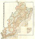
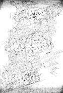
Talladega County
Talladega County
Talladega County
Talladega County
Talladega County
Talladega County
Talladega County
Talladega County
Talladega County
Publication Information
Montgomery: ASHD
Montgomery: ASHD
Montgomery: ASHD
Montgomery: ASHD
Montgomery: ASHD
Montgomery: ASHD
Montgomery: ASHD
Montgomery: ASHD
Montgomery: ASHD
Date
2009a
1999
1991
1982
1968
1963
1948
1938
1937
Scale
1:125,000
1:125,000
1:125,000
1:125,000
1:125,000
1:125,000
1:125,000
1:125,000
1:125,000
Viewing Options
Main Author:
LaTourrette, John
Title/Description:
An Accurate Map of the State of Alabama and West Florida [Sheet 9: Benton, Coosa, Randolph, St. Clair, Talladega, Tallapoosa]
Publication Info:
New York: Colton & Co., 1837
Viewing Options
Main Author:
LaTourrette, John
Title/Description:
An Accurate Map of the State of Alabama and West Florida [Sheet 12: Autauga, Bibb, Coosa, Montgomery, Shelby, Talladega]
Publication Info:
New York: Colton & Co., 1837

Viewing Options
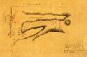
Main Author:
Cruikshank, M.H.
Title/Description:
Irona, Its Location and Surroundings
Publication Info:
Unknown publisher, c1876
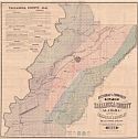
Viewing Options
Title/Description:
Sectional and Township Map of Talladega County, Alabama
Publication Info:
Chambers and Moseley, 1882
Viewing Options
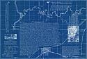
Main Author:
Walpole, E.A.
Title/Description:
The Lowell of the South
Publication Info:
Talladega: E.A. Walpole [c1890]; blueprint reproduction of original
Viewing Options
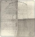
Main Author:
Edwards, John A.
Title/Description:
Official Map of Sylacauga, Alabama
Publication Info:
Childersburg: Edwards, John A., 1892; photostat copy of original
Viewing Options
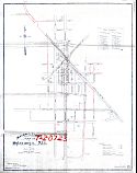
Title/Description:
Water and Light Map of Sylacauga, Ala.
Publication Info:
Atlanta: Arthur Pew, Ludwig and Co., 1905

Northern Half
Southern Half
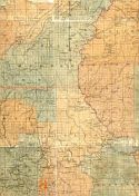
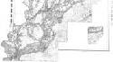
Main Author:
U.S. Department of Agriculture
Title/Description:
Talladega County soil survey map
Publication Info:
Washington: U.S. Department of Agriculture
Viewing Options
Main Author:
U.S. Department of Agriculture
Title/Description:
Talladega County soil survey map
Publication Info:
Washington: U.S. Department of Agriculture, 1907
Viewing Options
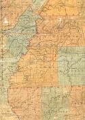
Main Author:
Bethel W. Whitson and Co.
Title/Description:
Map of Talladega County, Ala.
Publication Info:
Birmingham: Bethel W. Whitson and Co., [c1930]
Viewing Options
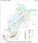
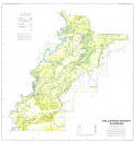
Main Author:
Causey, Lawson V.
Title/Description:
Geologic Rock - Type Map of Talladega County, Alabama
Publication Info:
Geological Survey of Alabama, Special Map 38
Viewing Options
Main Author:
Gilbert, Oscar E., Jr.
Title/Description:
Mineral Resources of Talladega County, Alabama
Publication Info:
Tuscaloosa: Geological Survey of Alabama, 1976; Special Map 174
Viewing Options
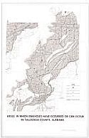
Main Author:
U.S. Geological Survey
Title/Description:
Areas in which sinkholes have occurred or can occur in Talladega County, Alabama
Publication Info:
Washington: Department of the Interior, U.S. Geological Survey, 1977
Viewing Options
Main Author:
U.S. Department of Agriculture
Title/Description:
Soil Interpretive Map of Important Farmlands for Talladega County, Alabama
Publication Info:
Washington: Department of Agriculture, Soil Conservation Service, 1980
Viewing Options
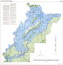
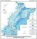
Main Author:
Moser, Paul H.
Title/Description:
Location of Wells and Springs and Potential Ground-Water Yields Talladega County, Alabama
Publication Info:
Tuscaloosa: Geological Survey of Alabama, 1988; Special Map 207, Plate I