Use the menu to the right to browse our collection of out-of-print editions of U.S.G.S. Quadrangles. Please keep in mind that map coverage varies and may not be complete for all counties.
Out-of-Print Quadrangles
Main Author
Alabama Highway Dept.
Alabama Highway Dept.
Alabama Highway Dept.
Alabama Highway Dept.
Alabama Highway Dept.
Alabama Highway Dept.
Alabama Highway Dept.
Alabama Highway Dept.
Alabama Highway Dept.
Location
Shelby County
Shelby County
Shelby County
Shelby County
Shelby County
Shelby County
Shelby County
Shelby County
Shelby County
Publication Information
Montgomery: ASHD
Montgomery: ASHD
Montgomery: ASHD
Montgomery: ASHD
Montgomery: ASHD
Montgomery: ASHD
Montgomery: ASHD
Montgomery: ASHD
Montgomery: ASHD
Date
2011
2001
1992
1988
1972
1965
1949
1938
1937
Scale
1:125,000
1:125,000
1:125,000
1:125,000
1:125,000
1:125,000
1:125,000
1:125,000
1:125,000
Viewing Options
Main Author:
LaTourrette, John
Title/Description:
An Accurate Map of the State of Alabama and West Florida [Sheet 7: Bibb, Jefferson, Shelby, Tuscaloosa, Walker]
Publication Info:
New York: Colton & Co., 1837
Viewing Options
Main Author:
LaTourrette, John
Title/Description:
An Accurate Map of the State of Alabama and West Florida [Sheet 12: Autauga, Bibb, Coosa, Montgomery, Shelby, Talladega]
Publication Info:
New York: Colton & Co., 1837
Viewing Options
Main Author:
LaTourrette, John
Title/Description:
An Accurate Map of the State of Alabama and West Florida [Sheet 16: Autauga, Bibb, Dallas, Jefferson, Perry, Shelby]
Publication Info:
New York: Colton & Co., 1837
Viewing Options
Main Author:
Safford, E.S.
Title/Description:
Shelby, Alabama
Publication Info:
blueprint copy of original map
Viewing Options
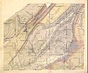
Main Author:
Squire, Joseph
Title/Description:
Map of the Cahaba Coal Field
Publication Info:
New York: Bien and Co., 1890; manuscript map of the SW quarter of the original of 1890; for the Geological Survey of Alabama
Viewing Options
Viewing Options
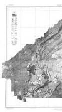
Main Author:
U.S. Department of Agriculture
Title/Description:
Shelby County soil survey map
Publication Info:
Washington: U.S. Department of Agriculture
Viewing Options
Main Author:
U.S. Department of Agriculture
Title/Description:
Shelby County soil survey map
Publication Info:
Washington: U.S. Department of Agriculture, 1917
Viewing Options
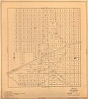
Main Author:
Turner, E.A.
Title/Description:
Road Map of Shelby County, Alabama
Publication Info:
Birmingham: Whitson Map and Blueprint Co., 1926
Viewing Options
Main Author:
Alabama State Planning Commission
Title/Description:
Town of Calera, Alabama
Publication Info:
Alabama State Planning Commission, 1941
Viewing Options
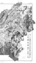
Main Author:
U.S. Department of Agriculture, Soil Conservation Service
Title/Description:
Soil Interpretive Map of Important Farmlands for Shelby County, Alabama
Publication Info:
Washington: U.S. Department of Agriculture, Soil Conservation Service, 1975
Viewing Options
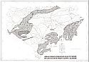
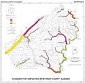
Main Author:
U.S. Department of the Interior, U.S. Geological Survey
Title/Description:
Areas in which sinkholes have occurred or can occur in Shelby County, Alabama
Publication Info:
United States Department of the Interior, U.S. Geological Survey, 1977
Viewing Options
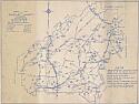
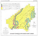
Main Author:
Harkins, J.R.
Title/Description:
Availability of Surface Water in Shelby County, Alabama
Publication Info:
Tuscaloosa: Geological Survey of Alabama, 1977; Map 140 Plate 2
Viewing Options
Main Author:
Shamburger, V.M.
Title/Description:
Availability of Ground Water in Shelby County, Alabama
Publication Info:
Tuscaloosa: Geological Survey of Alabama, 1977; Map 140 Plate I
Viewing Options
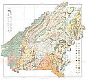
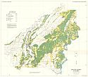
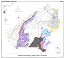
Main Author:
Tew, Berry H., Jr.
Title/Description:
Mineral Resources of Shelby County, Alabama
Publication Info:
Geological Survey of Alabama, Special Map 171

