Use the menu to the right to browse our collection of out-of-print editions of U.S.G.S. Quadrangles. Please keep in mind that map coverage varies and may not be complete for all counties.
Out-of-Print Quadrangles
Main Author
Alabama Highway Dept.
Alabama Highway Dept.
Alabama Highway Dept.
Alabama Highway Dept.
Alabama Highway Dept.
Alabama Highway Dept.
Alabama Highway Dept.
Alabama Highway Dept.
Location
Randolph County
Randolph County
Randolph County
Randolph County
Randolph County
Randolph County
Randolph County
Randolph County
Publication Information
Montgomery: ASHD
Montgomery: ASHD
Montgomery: ASHD
Montgomery: ASHD
Montgomery: ASHD
Montgomery: ASHD
Montgomery: ASHD
Montgomery: ASHD
Date
2009
2001
1992
1984
1974
1948
1938
1937
Scale
1:125,000
1:125,000
1:125,000
1:125,000
1:125,000
1:125,000
1:125,000
1:125,000
Viewing Options
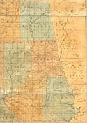
Main Author:
LaTourrette, John
Title/Description:
An Accurate Map of the State of Alabama and West Florida [Sheet 9: Benton, Coosa, Randolph, St. Clair, Talladega, Tallapoosa]
Publication Info:
New York: Colton & Co., 1837
Viewing Options
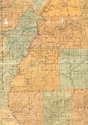
Main Author:
LaTourrette, John
Title/Description:
An Accurate Map of the State of Alabama and West Florida [Sheet 11: Chambers, Macon, Randolph, Russell, Tallapoosa]
Publication Info:
New York: Colton & Co., 1837
Viewing Options
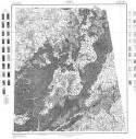
Main Author:
U.S. Department of Agriculture
Title/Description:
Randolph County soil survey map
Publication Info:
Washington: U.S. Department of Agriculture
Viewing Options
Main Author:
U.S. Department of Agriculture
Title/Description:
Randolph County soil survey map
Publication Info:
Washington: U.S. Department of Agriculture
Viewing Options
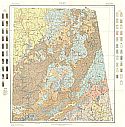
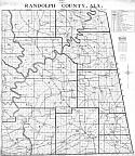
Main Author:
Bethel W. Whitson and Co.
Title/Description:
Randolph County, Alabama
Publication Info:
Birmingham: Bethel W. Whitson, [c1930]
Viewing Options
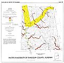
Main Author:
Lines, Gregory C. and Robert V. Chandler
Title/Description:
Water Availability of Randolph County, Alabama
Publication Info:
Tuscaloosa: Geological Survey of Alabama, 1975; Map 137
Viewing Options
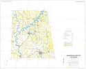
Main Author:
U.S. Department of Agriculture, Soil Conservation Service
Title/Description:
Soil Interpretive Map of Important Farmlands for Randolph County, Alabama
Publication Info:
U.S.D.A., Soil Conservation Service, c1980
Viewing Options
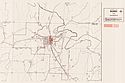
Main Author:
Office of State Planning and Federal Programs
Title/Description:
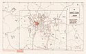
Town of Wedowee, Alabama
Publication Info:
Montgomery: Office of State Planning and Federal Programs, 1980; from Development Potentials Along the U.S. Highway 431 Corridor
Viewing Options
Main Author:
Office of State Planning and Federal Programs
Title/Description:
City of Roanoke, Alabama
Publication Info:
Montgomery: Office of State Planning and Federal Programs, 1980; from Development Potentials Along the U.S. Highway 431 Corridor
Viewing Options
Main Author:
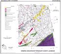
Beg, Mirza A.
Title/Description:
Mineral Resources of Randolph County, Alabama
Publication Info:
Geological Survey of Alabama, Special Map 206

