Use the menu to the right to browse our collection of out-of-print editions of U.S.G.S. Quadrangles. Please keep in mind that map coverage varies and may not be complete for all counties.
Out-of-Print Quadrangles
Main Author
Alabama Highway Dept.
Alabama Highway Dept.
Alabama Highway Dept.
Alabama Highway Dept.
Alabama Highway Dept.
Alabama Highway Dept.
Alabama Highway Dept.
Alabama Highway Dept.
Alabama Highway Dept.
Alabama Highway Dept.
Alabama Highway Dept.
Location
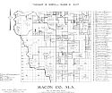
Macon County
Macon County
Macon County
Macon County
Macon County
Macon County
Macon County
Macon County
Macon County
Macon County
Macon County
Publication Information
Montgomery: ASHD
Montgomery: ASHD
Montgomery: ASHD
Montgomery: ASHD
Montgomery: ASHD
Montgomery: ASHD
Montgomery: ASHD
Montgomery: ASHD
Montgomery: ASHD
Montgomery: ASHD
Montgomery: ASHD
Date
2013
2005
1995
1987
1979
1967
1962
1953
1949
1938
1937
Scale
1:125,000
1:125,000
1:125,000
1:125,000
1:125,000
1:125,000
1:125,000
1:125,000
1:125,000
1:125,000
1:125,000
Viewing Options
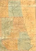
Main Author:
LaTourrette, John
Title/Description:
An Accurate Map of the State of Alabama and West Florida [Sheet 11: Chambers, Macon, Randolph, Russell, Tallapoosa]
Publication Info:
New York: Colton & Co., 1837
Viewing Options
Main Author:
LaTourrette, John
Title/Description:
An Accurate Map of the State of Alabama and West Florida [Sheet 15: Macon, Montgomery, Pike, Tallapoosa]
Publication Info:
New York: Colton & Co., 1837
Viewing Options
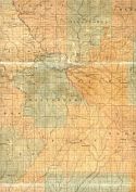
Main Author:
U.S. Department of Agriculture
Title/Description:
Macon County soil survey map
Publication Info:
Washington: U.S. Department of Agriculture
Viewing Options
Main Author:
U.S. Department of Agriculture
Title/Description:
Macon County soil survey map
Publication Info:
Washington: U.S. Department of Agriculture
Main Author:
Works Progress Administration
Title/Description:
Macon County Property Ownership Maps
Publication Info:
Montgomery: Alabama State Highway Department, 1936
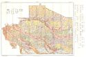
Viewing Options
Main Author:
U.S. Department of Agriculture
Title/Description:
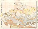
Soil Map of Macon County, Alabama
Publication Info:
Washington, D.C.: U.S. Department of Agriculture, 1937
Viewing Options
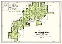
Main Author:
U.S. Department of Agriculture
Title/Description:
Tuskegee Land Utilization Project
Publication Info:
Washington: U.S. Dept. of Agriculture, Soil Conservation Service, 1949; reprinted 1953
Viewing Options
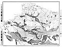
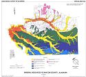
Main Author:
Dean, Lewis S.
Title/Description:
Mineral Resources of Macon County, Alabama
Publication Info:
Geological Survey of Alabama, Special Map 223