Use the menu to the right to browse our collection of out-of-print editions of U.S.G.S. Quadrangles. Please keep in mind that map coverage varies and may not be complete for all counties.
Out-of-Print Quadrangles
Main Author
Alabama Highway Dept.
Alabama Highway Dept.
Alabama Highway Dept.
Alabama Highway Dept.
Alabama Highway Dept.
Alabama Highway Dept.
Alabama Highway Dept.
Alabama Highway Dept.
Alabama Highway Dept.
Alabama Highway Dept.
Location
Lawrence County
Lawrence County
Lawrence County
Lawrence County
Lawrence County
Lawrence County
Lawrence County
Lawrence County
Lawrence County
Lawrence County
Publication Information
Montgomery: ASHD
Montgomery: ASHD
Montgomery: ASHD
Montgomery: ASHD
Montgomery: ASHD
Montgomery: ASHD
Montgomery: ASHD
Montgomery: ASHD
Montgomery: ASHD
Montgomery: ASHD
Date
2013
2005
1995
1986
1976
1965
1956
1949
1938
1937
Scale
1:125,000
1:125,000
1:125,000
1:125,000
1:125,000
1:125,000
1:125,000
1:125,000
1:125,000
1:125,000
Viewing Options
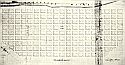
Main Author:
Coffee, John
Title/Description:
Melton's Bluff, AL
Publication Info:
Photocopy of hand-drawn original, c.1816-1818
Viewing Options
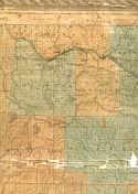
Main Author:
LaTourrette, John
Title/Description:
An Accurate Map of the State of Alabama and West Florida [Sheet 4: Franklin, Lauderdale, Lawrence, Marion, Walker]
Publication Info:
New York: Colton & Co., 1837
Viewing Options
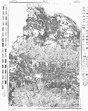
Main Author:
U.S. Department of Agriculture
Title/Description:
Lawrence County soil survey map
Publication Info:
Washington: U.S. Department of Agriculture
Viewing Options
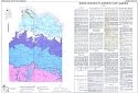
Main Author:
Harris, W.F., Jr. and William M. McMaster
Title/Description:
Generalized Geologic Map of Lawrence County, Alabama
Publication Info:
Geological Survey of Alabama, Special Map 31
Viewing Options
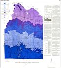
Main Author:
Geological Survey of Alabama
Title/Description:
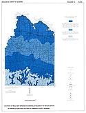
Locations of Wells and Springs and Generalized Availability of Ground Water at Depths of less than 200 feet in Lawrence County, Alabama
Publication Info:
Tuscaloosa: Geological Survey of Alabama, 1964; from Bulletin 78, Plate 1
Viewing Options
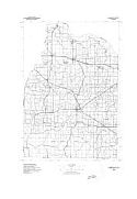
Main Author:
U.S. Geological Survey
Title/Description:
Lawrence County
Publication Info:
Washington, D.C.: Department of the Interior, U.S. Geological Survey, 1974; advance sheet for eventually unpublished map series
Viewing Options
Main Author:
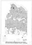
U.S. Department of the Interior, U.S. Geological Survey
Title/Description:
Areas in which sinkholes have occurred or can occur in Lawrence County, Alabama
Publication Info:
Department of the Interior, U.S. Geological Survey, 1977
Viewing Options
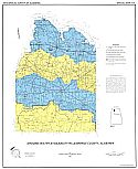
Main Author:
Hunter, Jonathon A. and Michael L. Epsman
Title/Description:
Ground-Water Availability in Lawrence County, Alabama
Publication Info:
Tuscaloosa: Geological Survey of Alabama, 1989; Special Map 213
Viewing Options
Main Author:
Dean, Lewis S.
Title/Description:
Mineral Resources of Lawrence County, Alabama
Publication Info:
Geological Survey of Alabama, Special Map 244

