Use the menu to the right to browse our collection of out-of-print editions of U.S.G.S. Quadrangles. Please keep in mind that map coverage varies and may not be complete for all counties.
Out-of-Print Quadrangles
Main Author
Alabama Highway Dept.
Alabama Highway Dept.
Alabama Highway Dept.
Alabama Highway Dept.
Alabama Highway Dept.
Alabama Highway Dept.
Alabama Highway Dept.
Alabama Highway Dept.
Alabama Highway Dept.
Alabama Highway Dept.
Location
Fayette County
Fayette County
Fayette County
Fayette County
Fayette County
Fayette County
Fayette County
Fayette County
Fayette County
Fayette County
Publication Information
Montgomery: ASHD
Montgomery: ASHD
Montgomery: ASHD
Montgomery: ASHD
Montgomery: ASHD
Montgomery: ASHD
Montgomery: ASHD
Montgomery: ASHD
Montgomery: ASHD
Montgomery: ASHD
Date
2007
1999
1990
1980
1970
1964
1960
1950
1938
1937
Scale
1:125,000
1:125,000
1:125,000
1:125,000
1:125,000
1:125,000
1:125,000
1:125,000
1:125,000
1:125,000
Viewing Options
Main Author:
LaTourrette, John
Title/Description:
An Accurate Map of the State of Alabama and West Florida [Sheet 8: Fayette, Greene, Perry, Pickens, Sumter, Tuscaloosa]
Publication Info:
New York: Colton & Co., 1837
Viewing Options
Main Author:
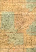
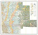
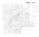
Smith, Eugene A.
Title/Description:
Geological Map of Fayette County
Publication Info:
unpublished manuscript map of 1878
Viewing Options
Main Author:
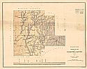
Smith, Eugene Allan
Title/Description:
Geological Map of Fayette County
Publication Info:
Tuscaloosa: Geological Survey of Alabama, 1878; published copy
Viewing Options
Main Author:
U.S. Geological Survey
Title/Description:
Reconnaisance Geologic Map of the Fayette District, Alabama
Publication Info:
Washington: Department of the Interior, United States Geological Survey, 1911
Viewing Options
Main Author:
U.S. Geological Survey
Title/Description:
Reconnaissance Geologic Map of the Fayette District, Alabama
Publication Info:
Washington: Department of the Interior, United States Geological Survey, 1911
Viewing Options
Main Author:
U.S. Department of Agriculture
Title/Description:
Fayette County soil survey map
Publication Info:
Washington: U.S. Department of Agriculture, 1917
Viewing Options
Main Author:
U.S. Department of Agriculture
Title/Description:
Fayette County soil survey map
Publication Info:
Washington: U.S. Department of Agriculture, 1917
Viewing Options
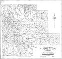
Title/Description:
Whitson's Map of Fayette County, Alabama
Publication Info:
Birmingham: Bethel W. Whitson & Co., c.1930
Viewing Options
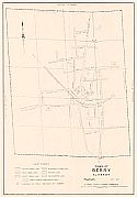
Main Author:
J.W. Goodwin Engineering Company
Title/Description:
Town of Berry, Alabama
Publication Info:
blue print of original map reproduced by the Alabama State Planning Commission
Viewing Options
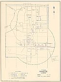
Main Author:
Alabama State Planning Commission
Title/Description:
City of Fayette, Alabama
Publication Info:
blueprint of original map reproduced by the Alabama State Planning Commission
Viewing Options
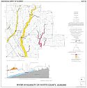
Main Author:
Knight, Alfred L.
Title/Description:
Water Availability of Fayette County, Alabama
Publication Info:
Tuscaloosa: Geological Survey of Alabama, 1972; Map 134
Viewing Options
Main Author:
Wilson, G.V. and J.C. Beasley
Title/Description:
Fayette County- Vertical Magnetic Intensity (manuscript map)
Publication Info:
Tuscaloosa: Geological Survey of Alabama, 1973
Viewing Options
Main Author:
Wilson, G.V.
Title/Description:
Fayette County - Bouguer Gravity (manuscript map)
Publication Info:
Tuscaloosa: Geological Survey of Alabama, 1973
Viewing Options
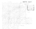
Main Author:
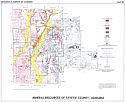
George, I.D., and Clarke, O.M.
Title/Description:
Mineral Resources Map of Fayette County, Alabama
Publication Info:
Tuscaloosa: Geological Survey of Alabama, Special Map 183
Viewing Options
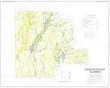
Main Author:
U.S. Department of Agriculture, Soil Conservation Service
Title/Description:
Soil Interpretive Map of Important Farmlands for Fayette County, Alabama
Publication Info:
Washington: U.S. Department of Agriculture, 1980

