Use the menu to the right to browse our collection of out-of-print editions of U.S.G.S. Quadrangles. Please keep in mind that map coverage varies and may not be complete for all counties.
Out-of-Print Quadrangles
Main Author
Alabama Highway Dept.
Alabama Highway Dept.
Alabama Highway Dept.
Alabama Highway Dept.
Alabama Highway Dept.
Alabama Highway Dept.
Alabama Highway Dept.
Alabama Highway Dept.
Alabama Highway Dept.
Location
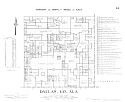
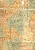
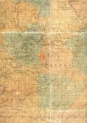
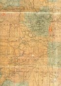
Dallas County
Dallas County
Dallas County
Dallas County
Dallas County
Dallas County
Dallas County
Dallas County
Dallas County
Publication Information
Montgomery: ASHD
Montgomery: ASHD
Montgomery: ASHD
Montgomery: ASHD
Montgomery: ASHD
Montgomery: ASHD
Montgomery: ASHD
Montgomery: ASHD
Montgomery: ASHD
Date
2007
1999
1990
1981
1968
1965
1950
1938
1937
Scale
1:125,000
1:125,000
1:125,000
1:125,000
1:125,000
1:125,000
1:125,000
1:125,000
1:125,000
Viewing Options
Main Author:
LaTourrette, John
Title/Description:
An Accurate Map of the State of Alabama and West Florida [Sheet 16: Autauga, Bibb, Dallas, Jefferson, Perry, Shelby]
Publication Info:
New York: Colton & Co., 1837
Viewing Options
Main Author:
LaTourrette, John
Title/Description:
An Accurate Map of the State of Alabama and West Florida [Sheet 19: Autuaga, Butler, Dallas, Lowndes, Perry, Wilcox]
Publication Info:
New York: Colton & Co., 1837
Viewing Options
Main Author:
LaTourrette, John
Title/Description:
An Accurate Map of the State of Alabama and West Florida [Sheet 20: Clarke, Conecuh, Dallas, Marengo, Monroe, Wilcox]
Publication Info:
New York: Colton & Co., 1837
Viewing Options
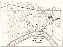
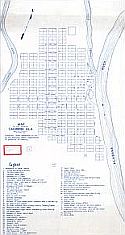
Main Author:
The Citizens' Union
Title/Description:
Map of the City of Selma, Alabama
Publication Info:
Selma: The Selma Printing Company, 1884
Viewing Options
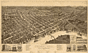
Title/Description:
Perspective Map of Selma, Alabama
Publication Info:
Milwaukee: Henry Wellge and Co., 1887
Viewing Options
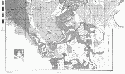
Main Author:
U.S. Department of Agriculture
Title/Description:
Dallas County soil survey map
Publication Info:
Washington: U.S. Department of Agriculture, 1905
Viewing Options
Viewing Options
Main Author:
U.S. Department of Agriculture
Title/Description:
Dallas County soil survey map
Publication Info:
Washington: U.S. Department of Agriculture, 1905
Viewing Options
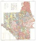
Main Author:
U.S. Department of Agriculture
Title/Description:
Soil Map of Dallas County, Alabama
Publication Info:
Washington: U.S. Department of Agriculture, 1932
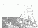
Main Author:
Works Progress Administration
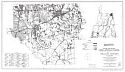
Title/Description:
Dallas County Property Ownership Maps
Publication Info:
Montgomery: Alabama State Highway Department, 1936
Viewing Options
Main Author:
Fleming, A.H.
Title/Description:
Map of the Town of Cahawba, Dallas County, Ala.
Publication Info:
Montgomery: A.H. Fleming, c.1950; blueprint copy of a map compiled from materials on file at the Alabama Dept. of Archives and History
Viewing Options
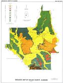
Main Author:
Scott, John C.
Title/Description:
Geologic Map of Dallas County, Alabama
Publication Info:
Tuscaloosa: Geological Survey of Alabama, Special Map 180, Plate 1
Viewing Options
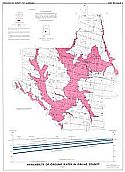
Title/Description:
Availability of Ground Water in Dallas County
Publication Info:
Tuscaloosa: Geological Survey of Alabama, 1970; Map 180 Plate 3
Viewing Options
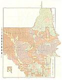
Main Author:
Alabama - Tombigbee Rivers Regional Planning & Development Commission
Title/Description:
Dallas County, Alabama - Existing Land Use Map
Publication Info:
Camden: Alabama - Tombigbee Rivers Regional Planning & Development Commission, 1971
Viewing Options
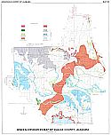
Main Author:
Szabo, Michael W.
Title/Description:
Mineral Resources Map of Dallas County, Alabama
Publication Info:
Tuscaloosa: Geological Survey of Alabama, 1975; Special Map 122

Viewing Options
Main Author:
U.S. Department of Agriculture, Soil Conservation Service
Title/Description:
Soil Interpretive Map of Important Farmlands for Dallas County, Alabama
Publication Info:
Washington: U.S. Department of Agriculture, 1979