Use the menu to the right to browse our collection of out-of-print editions of U.S.G.S. Quadrangles. Please keep in mind that map coverage varies and may not be complete for all counties.
Out-of-Print Quadrangles
Main Author
Alabama Highway Dept.
Alabama Highway Dept.
Alabama Highway Dept.
Alabama Highway Dept.
Alabama Highway Dept.
Alabama Highway Dept.
Alabama Highway Dept.
Alabama Highway Dept.
Location
Coosa County
Coosa County
Coosa County
Coosa County
Coosa County
Coosa County
Coosa County
Coosa County
Publication Information
Montgomery: ASHD
Montgomery: ASHD
Montgomery: ASHD
Montgomery: ASHD
Montgomery: ASHD
Montgomery: ASHD
Montgomery: ASHD
Montgomery: ASHD
Date
2008
2000
1992
1984
1974
1953
1938
1937
Scale
1:125,000
1:125,000
1:125,000
1:125,000
1:125,000
1:125,000
1:125,000
1:125,000
Viewing Options
Main Author:
LaTourrette, John
Title/Description:
An Accurate Map of the State of Alabama and West Florida [Sheet 9: Benton, Coosa, Randolph, St. Clair, Talladega, Tallapoosa]
Publication Info:
New York: Colton & Co., 1837
Viewing Options
Main Author:
LaTourrette, John
Title/Description:
An Accurate Map of the State of Alabama and West Florida [Sheet 12: Autauga, Bibb, Coosa, Montgomery, Shelby, Talladega]
Publication Info:
New York: Colton & Co., 1837
Viewing Options
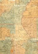
Main Author:
Dean, Charles A.
Title/Description:
Timbered and Farm Lands Owned by J.M. Steverson of Alexander City, Alabama
Publication Info:
Unknown publisher, 1917
Viewing Options
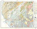
Main Author:
U.S. Department of Agriculture
Title/Description:
Coosa County soil survey map
Publication Info:
Washington: U.S. Department of Agriculture, 1929
Viewing Options
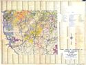
Main Author:
U.S. Department of Agriculture
Title/Description:
Coosa County soil survey map
Publication Info:
Washington: U.S. Department of Agriculture, 1929
Viewing Options
Title/Description:
Whitson's Map of Coosa County, Alabama
Publication Info:
Birmingham: Bethel W. Whitson, 1930
Viewing Options
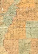
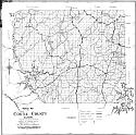
Main Author:
Alabama State Highway Department
Title/Description:
General Highway and Transportation Map, Coosa County, Alabama
Publication Info:
Montgomery: Alabama State Highway Department, 1937
Viewing Options
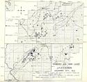
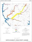
Main Author:
Lines, Gregory, C., and Scott, John C.
Title/Description:
Water Availability, Coosa County, Alabama
Publication Info:
Tuscaloosa: Geological Survey of Alabama, 1972; Map 111
Viewing Options
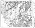
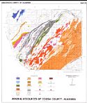
Main Author:
Neathery, Thornton L.
Title/Description:
Mineral Resources Map of Coosa County, Alabama
Publication Info:
Tuscaloosa: Geological Survey of Alabama, Special Map 152

