Use the menu to the right to browse our collection of out-of-print editions of U.S.G.S. Quadrangles. Please keep in mind that map coverage varies and may not be complete for all counties.
Out-of-Print Quadrangles
Main Author
Alabama Highway Dept.
Alabama Highway Dept.
Alabama Highway Dept.
Alabama Highway Dept.
Alabama Highway Dept.
Alabama Highway Dept.
Alabama Highway Dept.
Alabama Highway Dept.
Alabama Highway Dept.
Alabama Highway Dept.
Location
Cherokee County
Cherokee County
Cherokee County
Cherokee County
Cherokee County
Cherokee County
Cherokee County
Cherokee County
Cherokee County
Cherokee County
Publication Information
Montgomery: ASHD
Montgomery: ASHD
Montgomery: ASHD
Montgomery: ASHD
Montgomery: ASHD
Montgomery: ASHD
Montgomery: ASHD
Montgomery: ASHD
Montgomery: ASHD
Montgomery: ASHD
Date
2009
2001
1993
1983
1973
1965
1960
1949
1938
1937
Scale
1:125,000
1:125,000
1:125,000
1:125,000
1:125,000
1:125,000
1:125,000
1:126,720
1:125,000
1:125,000
Viewing Options
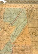
Main Author:
LaTourrette, John
Title/Description:
An Accurate Map of the State of Alabama and West Florida [Sheet 2: Cherokee, DeKalb, Jackson]
Publication Info:
New York: Colton & Co., 1837
Viewing Options
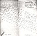
Main Author:
Allan, Asa W. and McDaniel, W.E.
Title/Description:
A Plan of the Town Laid off at Cherokee Court House (Centre)
Publication Info:
copied by T.E. Wafford, Engineers, Gadsden from original made around 1842
Viewing Options
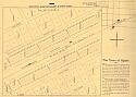
Main Author:
The Ogden Land Company
Title/Description:
The Town of Ogden
Publication Info:
Unknown publisher, c.1880
Viewing Options
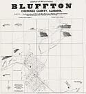
Title/Description:
Plat of the City of Bluffton, Cherokee County, Alabama
Publication Info:
Atlanta: Budden & Son, c.1900
Viewing Options
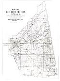
Main Author:
W.W. Ward, Company
Title/Description:
Map of Cherokee Co., Alabama
Publication Info:
W.W. Ward, Co,. 1917; photocopy of original map
Viewing Options
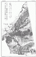
Main Author:
U.S. Department of Agriculture
Title/Description:
Cherokee County soil survey map
Publication Info:
Washington: U.S. Department of Agriculture, 1924
Viewing Options
Main Author:
U.S. Department of Agriculture
Title/Description:
Cherokee County soil survey map
Publication Info:
Washington: U.S. Department of Agriculture, 1924
Viewing Options
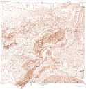
Main Author:
U.S. Department of Interior, Geological Survey
Title/Description:
Rock Run and Vicinity, Alabama
Publication Info:
Washington: Government Printing Office, 1941
Viewing Options
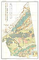
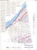
Main Author:
Causey, Lawson V.
Title/Description:
Generalized Geologic Map of Cherokee County, Alabama
Publication Info:
Tuscaloosa: Geological Survey of Alabama, Special Map 39
Viewing Options
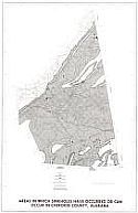
Main Author:
United States Geological Survey
Title/Description:
Areas in which sinkholes have occured or can occur in Cherokee County, Alabama
Publication Info:
Washington: U.S. Department of Interior, U.S. Geological Survey, 1977
Viewing Options
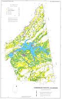
Main Author:
U.S. Department of Agriculture, Soil Conservation Service
Title/Description:
Soil Interpretive Map of Important Farmlands for Cherokee County, Alabama
Publication Info:
Washington: Department of Agriculture, 1979
Viewing Options
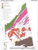
Main Author:
Rheams, Karen F.
Title/Description:
Mineral Resources of Cherokee County, Alabama
Publication Info:
Tuscaloosa: Geological Survey of Alabama, Special Map 217

