Use the menu to the right to browse our collection of out-of-print editions of U.S.G.S. Quadrangles. Please keep in mind that map coverage varies and may not be complete for all counties.
Out-of-Print Quadrangles
Main Author
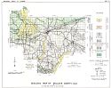
Alabama Highway Dept.
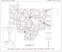
Alabama Highway Dept.
Alabama Highway Dept.
Alabama Highway Dept.
Alabama Highway Dept.
Alabama Highway Dept.
Alabama Highway Dept.
Alabama Highway Dept.
Alabama Highway Dept.
Location
Bullock County
Bullock County
Bullock County
Bullock County
Bullock County
Bullock County
Bullock County
Bullock County
Bullock County
Publication Information
Montgomery: ASHD
Montgomery: ASHD
Montgomery: ASHD
Montgomery: ASHD
Montgomery: ASHD
Montgomery: ASHD
Montgomery: ASHD
Montgomery: ASHD
Montgomery: ASHD
Date
2006
1997
1988
1980
1967
1960
1949
1938
1937
Scale
1:125,000
1:125,000
1:125,000
1:125,000
1:125,000
1:125,000
1:125,000
1:125,000
1:125,000
Viewing Options
Main Author:
U.S. Department of Agriculture
Title/Description:
Bullock County soil survey map
Publication Info:
Washington: U.S. Department of Agriculture, 1913
Viewing Options
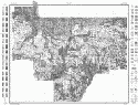
Main Author:
U.S. Department of Agriculture
Title/Description:
Bullock County soil survey map
Publication Info:
Washington: U.S. Department of Agriculture, 1913
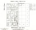
Main Author:
Works Progress Administration
Title/Description:
Bullock County Property Ownership Maps
Publication Info:
Montgomery: Alabama State Highway Department, 1936
Viewing Options
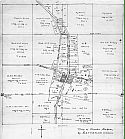
Main Author:
G.B. Pickett Engineers
Title/Description:
Map of Perote, Alabama
Publication Info:
Hand-drafted by author, c. 1940
Original Source:
James Pickett of Montgomery, Alabama
Viewing Options
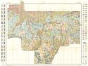
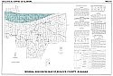
Main Author:
Scott, John C., modified from Eargle, D.H.
Title/Description:
Geologic Map of Bullock County, Alabama
Publication Info:
Tuscaloosa: Geologic Survey of Alabama, Special Map 19
Viewing Options
Main Author:
Geological Survey of Albama
Title/Description:
Map Showing Location of Wells in Bullock County and Areas of Artesian Flow
Publication Info:
Tuscaloosa: Geological Survey of Alabama, 1962; from Information Series 29, Plate 1
Viewing Options
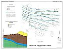
Main Author:
Clarke, O.M. Jr., and M.W. Szabo
Title/Description:
Mineral Resources Map of Bullock County, Alabama
Publication Info:
Tuscaloosa: Geological Survey of Alabama, 1966; Special Map 53
Viewing Options
Main Author:
Gillett, Blackney
Title/Description:
Hydrogeology of Bullock County, Alabama
Publication Info:
Tuscaloosa: Geological Survey of Alabama, 1990; Special Map 210 Plate 1