Historical Maps from the Civil War

  Main Author:   Colton, G.W.
  Title/Description:   
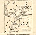
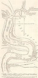
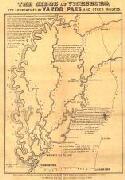
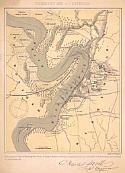
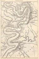
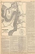
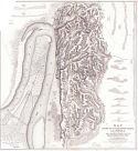
Map of Vicksburg Miss., with the Positions of the Federal Fleets and Rebel Batteries, Also the Site of the Canal Now Being Cut, by Order of Gen. Butler, to Change the Course of the Mississippi
  Publication Info:   New York: Frank Leslie's Illlustrated Newspaper, 1862; p.283, July 26, 1862
  Date:   1862
  Scale:   1:125,000
  Original Source:   Courtesy of Murray Hudson, Halls, Tennessee
Viewing options:


  Main Author:    
  Title/Description:   Map of the Mississippi and Yazoo Rivers, Where the Great Naval Combat Between the U.S. Gunboat Carondelet and the Rebel Ram Arkansas Took Place, July 15
  Publication Info:   New York: Frank Leslie's Illlustrated Newspaper, 1862; p.310, August 9, 1862
  Date:   1862
  Scale:   1:70,000
  Original Source:   Courtesy of Murray Hudson, Halls, Tennessee
Viewing options:


  Main Author:    
  Title/Description:   The Siege of Vicksburg, its Approaches by Yazoo and Other Routes
  Publication Info:   Mobile: S.H. Goetzel and Co., 1863
  Date:   1863
  Scale:   not indicated
  Original Source:   Alabama Department of Archives and History
Viewing options:


  Main Author:   Kemble, W.
  Title/Description:   Vicksburg and It's Defences (sic)
  Publication Info:   Unknown publisher, c. 1863
  Date:   1863
  Scale:   1:50,000
  Original Source:   Alabama Department of Archives and History
Viewing options:


  Main Author:    
  Title/Description:   Map of the Mississippi, From Haine's Bluff to Below Grand Gulf, Showing the Theatre of Gen. Grant's and Admiral Farragut's Operations, etc.
  Publication Info:   New York: Harper's Weekly, 1863; p.327, May 23, 1863
  Date:   1863
  Scale:   1:47,500
  Original Source:   Courtesy of Murray Hudson, Halls, Tennessee
Viewing options:


  Main Author:    
  Title/Description:   Map of Vicksburg and Vicinity
  Publication Info:   New York: New-York Tribune, 1863; from the front page of the edition dated Wednesday, March 4, 1863
  Date:   1863
  Scale:   1:125,000
  Original Source:   Courtesy of Murray Hudson, Halls, Tennessee
Viewing options:


  Main Author:    
  Title/Description:   Vicksburg and Its Vicinity
  Publication Info:   New York: Harper's Weekly, 1863; p.158, March 7, 1863
  Date:   1863
  Scale:   1:69,000
  Original Source:   Courtesy of Murray Hudson, Halls, Tennessee
Viewing options:


  Main Author:   Comstock, C.B. and J.H. Wilson
  Title/Description:   Map of the Siege of Vicksburg, Miss. by U.S. Forces under the command of Maj. Gen. U.S. Grant
  Publication Info:   New York: S. Schedler, [c. 1875]
  Date:   1875
  Scale:   1:15,840
  Original Source:   Courtesy of the U.S. Army Corps of Engineers
Viewing options:


© University of Alabama
To purchase map reproductions, submit a quote request.
Download MrSID Plugin