Historical Maps from the Civil War

  Main Author:   Bachmann, John
  Title/Description:   Panorama of the Seat of War - Bird's Eye View of Louisiana, Mississippi, Alabama and part of Florida
  Publication Info:   New York: John Bachmann, 1861
  Date:   1861
  Scale:   oblique view
  Original Source:   W. S. Hoole Special Collections Library
Viewing options:


  Main Author:    
  Title/Description:   Franklin, Tennessee and Vicinity
  Publication Info:   Unpublished, hand drawn
  Date:   1862
  Scale:   not indicated
  Original Source:   Alabama Department of Archives and History
Viewing options:


  Main Author:    
  Title/Description:   Vicinity Map of Bandstown and Harrodsburg, Kentucky
  Publication Info:   Unpublished, hand drawn
  Date:   1862
  Scale:   not indicated
  Original Source:   Alabama Department of Archives and History
Viewing options:


  Main Author:   Matz, Otto H.
  Title/Description:   Map of the Country between Monterey, Tenn. and Corinth, Miss.
  Publication Info:   New York: J. Bien, [1862]
  Date:   1862
  Scale:   1:31,680
  Original Source:   Courtesy of the U.S. Army Corps of Engineers
Viewing options:


  Main Author:    
  Title/Description:   The Rebel General Zollicoffer's Position on the Cumberland River
  Publication Info:   New York: The New York Herald, 1862; from the front page of the edition dated Thursday, January 9, 1862
  Date:   1862
  Scale:   1:50,000
  Original Source:   Courtesy of Murray Hudson, Halls, Tennessee
Viewing options:


  Main Author:   Leslie, Frank
  Title/Description:   
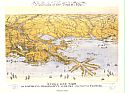
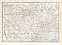
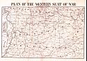
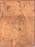
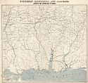
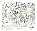
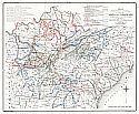
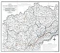
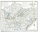
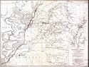
Map of the Seat of War in the West, Including Southern Missouri, Northern Arkansas, and Western Kentucky and Tennessee, With the Localities of the Recent Battles, and the National and Rebel Positions
  Publication Info:   Frank Leslie, 1862; from Pictorical History of the American Civil War, Vol.1
  Date:   1862
  Scale:   1:1,584,000
  Original Source:   Courtesy of Murray Hudson, Halls, Tennessee
Viewing options:


  Main Author:   Lathrop, H.P.
  Title/Description:   Plan of the Western Seat of War
  Publication Info:   New Orleans: H.P. Lathrop, 1862
  Date:   1862
  Scale:   1:1,584,000
  Original Source:   Birmingham Public Library Cartography Collection
Viewing options:


  Main Author:   Chamberlin, John R.
  Title/Description:   Topographical Map of Corinth and Vicinity
  Publication Info:   hand drawn
  Date:   1862
  Scale:   1:15,640
  Original Source:   W. S. Hoole Special Collections Library
Viewing options:


  Main Author:    
  Title/Description:   Dandridge, Tennessee and Vicinity
  Publication Info:   Unpublished, hand drawn
  Date:   1863
  Scale:   1:250,000
  Original Source:   Alabama Department of Archives and History
Viewing options:


  Main Author:   Coastal Survey Office
  Title/Description:   Southern Mississippi and Alabama showing approaches to Mobile
  Publication Info:   Edward Molitor, Lith, 1863
  Date:   1863
  Scale:   1:633,000
  Original Source:   Courtesy of Tom McMillan, Brewton, Alabama
Viewing options:


  Main Author:    
  Title/Description:   Panorama of the Mississippi Valley and its Fortifications
  Publication Info:   New York: C. Magnus, [1863]
  Date:   1863
  Scale:    
  Original Source:   Birmingham Public Library Cartography Collection
Viewing options:


  Main Author:    
  Title/Description:   Map of the Seat of War in Mississippi
  Publication Info:   The Constitutionalist [1863]
  Date:   1863
  Scale:   1:633,000
  Original Source:   Birmingham Public Library Cartography Collection
Viewing options:


  Main Author:    
  Title/Description:   Map of the Mississippi, from Haines's Bluff to Below Grand Gulf, Showing the Theatre of General Grant's and Admiral Farragut's Operations, Etc.
  Publication Info:   New York: Harper's Weekly, May 23, 1863, page 327
  Date:   1863
  Scale:   1:47,520
  Original Source:   Courtesy of Murray Hudson, Halls, Tennessee
Viewing options:


  Main Author:    
  Title/Description:   Map Showing the Operations of the Yazoo Pass Expedition, and the Proposed New Water Line to the Gulf
  Publication Info:   New York: Harper's Weekly, 1863; p.199, March 28, 1863
  Date:   1863
  Scale:   1:1,584,000
  Original Source:   Courtesy of Murray Hudson, Halls, Tennessee
Viewing options:


  Main Author:    
  Title/Description:   Map of Mississippi, Showing the Field of Operations of Generals Sherman, Grant, and Banks
  Publication Info:   New York: Harper's Weekly, 1863; p.43, January 17, 1863
  Date:   1863
  Scale:   1:2,091,000
  Original Source:   Courtesy of Murray Hudson, Halls, Tennessee
Viewing options:


  Main Author:    
  Title/Description:   Map Illustrating Forrest's Tennessee Expedition
  Publication Info:   New York: Harper's Weekly, 1864; p.571, February 1864
  Date:   1864
  Scale:   1:2,091,000
  Original Source:   Courtesy of Murray Hudson, Halls, Tennessee
Viewing options:


  Main Author:   Lindenkohl, A.
  Title/Description:   Northern Mississippi and Alabama
  Publication Info:   Washington: U.S. Coast Survey Office, 1864
  Date:   1864
  Scale:   1:633,600
  Original Source:   W. S. Hoole Special Collections Library
Viewing options:


  Main Author:   United States Army
  Title/Description:   Campaign of the Army of West Mississippi, Major General E.R.S. Canby commanding, in Southern Alabama, March and April, 1865
  Publication Info:   [s.l. : s.n.], 1865
  Date:   1865
  Scale:   1:310,000
  Original Source:   W. S. Hoole Special Collections Library
Viewing options:


  Main Author:   Hoeleke, Captain William
  Title/Description:   Map showing the system of rebel fortifications on the Mississippi River at Island No. 10 and New Madrid
  Publication Info:   Philadelphia: Bowen and Co., [1866]; for the report of Maj. Gen. John Pope to the committee on the Conduct of the War.
  Date:   1866
  Scale:   1:45,000
  Original Source:   Birmingham Public Library Cartography Collection
Viewing options:


  Main Author:   U.S. Army Engineer Department
  Title/Description:   Untitled Map of Mobile Bay
  Publication Info:   Washington: 1866
  Date:   1866
  Scale:   1:80,000
  Original Source:   A.S. Williams III Americana Collection Library
Viewing options:


  Main Author:   U.S. Army Engineer Department
  Title/Description:   Seige Operations of Spanish Fort, Mobile Bay
  Publication Info:   Philadelphia: Bowen and Co., 1866; from a report to the 39th Congress, 1st Session
  Date:   1866
  Scale:   1:16,200
  Original Source:   A.S. Williams III Americana Collection Library
Viewing options:


  Main Author:    
  Title/Description:   Map Illustrating Forrest's Tennessee Expeditom
  Publication Info:   New York: Harper and Brother, 1968; from Harper Pictorial History of the Civil War
  Date:   1868
  Scale:   1:2,027,520
  Original Source:   Courtesy of the U.S. Army Corps of Engineers
Viewing options:


  Main Author:    
  Title/Description:   Topographic Map of the Approaches and Defences of Knoxville, Tennessee Shewing the positions occupied by the United States and Confederate Forces during the seige
  Publication Info:   New York: The Graphic Co., (c. 1875); published by authority of the Secretary of War in the Office of the Chief of Engineers, U.S. Army
  Date:   1875
  Scale:   1:8,448
  Original Source:   Courtesy of the U.S. Army Corps of Engineers
Viewing options:


  Main Author:    
  Title/Description:   Map of Port Hudson and Vicinity (Louisiana)
  Publication Info:   Published by authority of the Secretary of War in the Office of the Chief of Engineers, U.S. Army
  Date:   1875
  Scale:   1:7,920
  Original Source:   Courtesy of the U.S. Army Corps of Engineers
Viewing options:


  Main Author:   Ruger, Edward and Thomas B. Van Horne
  Title/Description:   Map Exhibiting the operations of the Armies of the Cumberland and Ohio while commanded respectively by Brig. Gen Robert Anderson, Brig. Gen W.T. Sherman and Maj. Gen. D.C. Buell
  Publication Info:   Cincinnati: Robert Clarke and Company, 1875; from History of the Army of Cumberland
  Date:   1875
  Scale:   1:1,267,200
  Original Source:   Courtesy of Murray Hudson, Halls, Tennessee
Viewing options:


  Main Author:   Ruger, Edward and Thomas B. Van Horne
  Title/Description:   Map Exhibiting the Campaigns of the Army of the Cumberland while under the command of Maj. Gen. W.S. Rosecrans
  Publication Info:   Cincinnati: Robert Clarke and Company, 1875; from History of the Army of Cumberland
  Date:   1875
  Scale:   1:950,400
  Original Source:   Courtesy of Murray Hudson, Halls, Tennessee
Viewing options:


  Main Author:   Ruger, Edward and Thomas B. Van Horne
  Title/Description:   Map Prepared to exhibit the Campaigns in which the Army of the Cumberland took part during the War of the Rebellion
  Publication Info:   Cincinnati: Robert Clarke and Company, 1875; from History of the Army of Cumberland
  Date:   1875
  Scale:   1:2,661,000
  Original Source:   Courtesy of Murray Hudson, Halls, Tennessee
Viewing options:


  Main Author:   Ruger, Edward and Thomas B. Van Horne
  Title/Description:   Map Exhibiting the Chattanooga & East Tennessee Campaigns in conjunction
  Publication Info:   Cincinnati: Robert Clarke and Company, 1875; from History of the Army of Cumberland
  Date:   1875
  Scale:   1:1,267,200
  Original Source:   Courtesy of Murray Hudson, Halls, Tennessee
Viewing options:


  Main Author:   Ruger, Edward and Thomas B. Van Horne
  Title/Description:   Map Exhibiting the operations conducted pursuant to the orders if Maj. Gen. George Thomas
  Publication Info:   Cincinnati: Robert Clarke and Company, 1875; from History of the Army of Cumberland
  Date:   1875
  Scale:   1:2,661,000
  Original Source:   Courtesy of Murray Hudson, Halls, Tennessee
Viewing options:


  Main Author:    
  Title/Description:   Map of the Battle of Iuka, Mississippi
  Publication Info:   Published by authority of the Secretary of War in the Office of the Chief of Engineers, U.S. Army
  Date:   1876
  Scale:   1:6,300
  Original Source:   Courtesy of the U.S. Army Corps of Engineers
Viewing options:


  Main Author:   Matz, Otto H., and L. Helmle
  Title/Description:   Map of the Country Between Millikens Bend, La, and Jackson, Ms, shewing the routes followed by the Army of the Tennessee
  Publication Info:   Published by authority of the Secretary of War in the Office of the Chief of Engineers, U.S. Army
  Date:   1876
  Scale:   1:31,680
  Original Source:   Courtesy of the U.S. Army Corps of Engineers
Viewing options:


  Main Author:   Vorzet, Edward Dumas and L. Wuhrer
  Title/Description:   Iuka - Chickasaw Bayou - Murfreesborough
  Publication Info:   Paris: Michel Levey, 1879; from the Comte de Paris Atlas of the American Civil War; plate XVII
  Date:   1876
  Scale:   various scales
  Original Source:   Courtesy of Murray Hudson, Halls, Tennessee
Viewing options:


  Main Author:    
  Title/Description:   Map Showing the Military Defences of Cincinnati, Covington and Newport
  Publication Info:   Published by authority of the Secretary of War in the Office of the Chief of Engineers, U.S. Army
  Date:   1877
  Scale:   1:15,840
  Original Source:   Courtesy of the U.S. Army Corps of Engineers
Viewing options:


  Main Author:   Page, R.L.
  Title/Description:   Defence of Fort Morgan, August 1864
  Publication Info:   [Boston: 1878]
  Date:   1878
  Scale:   various scales
  Original Source:   Birmingham Public Library Cartography Collection
Viewing options:


  Main Author:   Farragut, D.G.
  Title/Description:   Entrance of Rear Admiral Farragut in to Mobile Bay, August 5, 1864
  Publication Info:   [Boston: 1878]
  Date:   1878
  Scale:   not indicated
  Original Source:   Birmingham Public Library Cartography Collection
Viewing options:


  Main Author:   Jones, Oscar
  Title/Description:   Map of the Battlefield of Stones River, Tennessee
  Publication Info:   Stones River Battlefield and National Park Association, 1900
  Date:   1900
  Scale:   1:9,600
  Original Source:   A.S. Williams III Americana Collection
Viewing options:


  Main Author:    
  Title/Description:   Tennessee Valley, Waterloo to Rodgersville, Alabama
  Publication Info:   Unpublished, hand drawn
  Date:   no date
  Scale:   not indicated
  Original Source:   Alabama Department of Archives and History
Viewing options:


  Main Author:    
  Title/Description:   Central Tennessee
  Publication Info:   Unpublished, hand drawn
  Date:   no date
  Scale:   1:760,000
  Original Source:   Alabama Department of Archives and History
Viewing options:


  Main Author:    
  Title/Description:   Murfreesboro, Shelbyville, and vicinity, Tennessee
  Publication Info:   Unpublished, hand drawn
  Date:   no date
  Scale:   not indicated
  Original Source:   Alabama Department of Archives and History
Viewing options:


  Main Author:    
  Title/Description:   Central Tennessee - Nashville to Fayetteville
  Publication Info:   Unpublished, hand drawn
  Date:   no date
  Scale:   no scale
  Original Source:   Alabama Department of Archives and History
Viewing options:


  Main Author:    
  Title/Description:   Map of Mobile and Defence's (sic)
  Publication Info:   Unpublished, hand drawn
  Date:   no date
  Scale:   not indicated
  Original Source:   Alabama Department of Archives and History
Viewing options:


  Main Author:    
  Title/Description:   SE Limestone County
  Publication Info:   Unpublished, hand drawn
  Date:   no date
  Scale:   1:125,000
  Original Source:   Alabama Department of Archives and History
Viewing options:


  Main Author:    
  Title/Description:   Descriptions of Fortifications in December, 1863 [Selma]
  Publication Info:   Unpublished, hand drawn; War Department Records
  Date:   no date
  Scale:   not indicated
  Original Source:   Alabama Department of Archives and History
Viewing options:


© University of Alabama
To purchase map reproductions, submit a quote request.
Download MrSID Plugin