Historical Maps from the Civil War


  Main Author:    
  Title/Description:   The Capture of Beaufort, South Carolina
  Publication Info:   New York: Harper's Weekly, November 30, 1861
  Date:   1861
  Scale:   1:507,000
  Original Source:   Courtesy of Murray Hudson, Halls, Tennessee
Viewing options:


  Main Author:    
  Title/Description:   Map of North Carolina, Showing Fort Hatteras and the Sound it Commands
  Publication Info:   New York: Harper's Weekly, 1861; p.635, October 5, 1861
  Date:   1861
  Scale:   1:1,140,000
  Original Source:   Courtesy of Murray Hudson, Halls, Tennessee
Viewing options:


  Main Author:   Colton, G. Woolworth
  Title/Description:   Map of the Southern and Border States, showing the Actual Positions of the National and Rebel Forces, and of the Blockading Fletes and Vessels, the Positions of the Various Fortifications that have been Erected, and the Localities of All the Important Battles that have been Fought During the Period
  Publication Info:   New York: Frank Leslie's Illustrated Newspaper, 1861
  Date:   1861
  Scale:   1:3,168,000
  Original Source:   Alabama Department of Archives and History
Viewing options:


  Main Author:   Colton, G.W.
  Title/Description:   
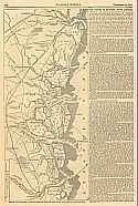
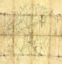
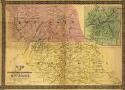
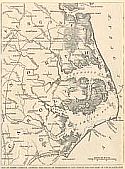
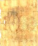
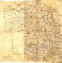
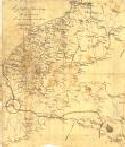
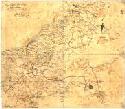
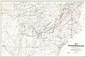
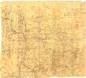
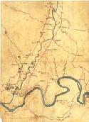
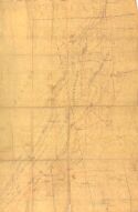
James Island, Near Charleston S.C., with the Position of the Federal Camps, and the Plan of the Advance of Our Forces to Attack the Rebal Batteries Near Secessionville, June 16
  Publication Info:   New York: Frank Leslies Illustrated Newspaper, 1862; p.246, July 12, 1862
  Date:   1862
  Scale:   1:70,000
  Original Source:   Courtesy of Murray Hudson, Halls, Tennessee
Viewing options:


  Main Author:   Tyner, Capt. J.S., Co. K, First Confederate Cavalry  
  Title/Description:   Map of Northern Georgia and Tennessee
  Publication Info:   Unpublished, hand drawn
  Date:   c1863
  Scale:   1:125,000
  Original Source:   Alabama Department of Archives and History
Viewing options:


  Main Author:    
  Title/Description:   Map Northern Georgia and Tennessee
  Publication Info:   Augusta: J.T. Patterson & Co., 1863
  Date:   1863
  Scale:   1:88,000
  Original Source:   Alabama Department of Archives and History
Viewing options:


  Main Author:    
  Title/Description:   Map of North Carolina, Showing the Field Operations of Gen. Foster and the Army of the Blackwater
  Publication Info:   New York: Harper's Weekly, 1863; p.7, January 3, 1863
  Date:   1863
  Scale:   1:1,204,000
  Original Source:   Courtesy of Murray Hudson, Halls, Tennessee
Viewing options:


  Main Author:   Engineer's Office of Wheeler's Cavalry Corps.  
  Title/Description:   North Georgia centered on Dalton
  Publication Info:   Unpublished, hand drawn
  Date:   May 11, 1864
  Scale:   1:63,000
  Original Source:   Alabama Department of Archives and History
Viewing options:


  Main Author:   Engineer's Office, Cavalry Corps., Jno M. Stewart, Asst. Eng.  
  Title/Description:   Marietta and Vicinity
  Publication Info:   Unpublished, hand drawn
  Date:   June 14, 1864
  Scale:   1:125,000
  Original Source:   Alabama Department of Archives and History
Viewing options:


  Main Author:   Engineer's Office, Cavalry Corps.  
  Title/Description:   North Central Georgia
  Publication Info:   Unpublished, hand drawn
  Date:   June 15, 1864
  Scale:   1:90,000
  Original Source:   Alabama Department of Archives and History
Viewing options:


  Main Author:   Engineer's Office, Cavalry Corps., Jno M. Stewart, Asst. Eng.  
  Title/Description:   NW Georgia: Resacca to Kingston
  Publication Info:   Unpublished, hand drawn
  Date:   July 3, 1864
  Scale:   1:125,000
  Original Source:   Alabama Department of Archives and History
Viewing options:


  Main Author:   Engineer's Office, Cavalry Corps., Jno M. Stewart, Asst. Eng  
  Title/Description:   Georgia: Atlanta, Stone Mountain, and vicinity
  Publication Info:   Unpublished, hand drawn
  Date:   July 18, 1864
  Scale:   1:125,000
  Original Source:   Alabama Department of Archives and History
Viewing options:


  Main Author:   Engineer's Office, Cavalry Corps, Jno. M. Stewart, Asst. Eng.  
  Title/Description:   Atlanta and vicinity
  Publication Info:   Unpublished, hand drawn
  Date:   1864
  Scale:   1:125,000
  Original Source:   Alabama Department of Archives and History
Viewing options:


  Main Author:    
  Title/Description:   Map of Gen. Sherman's Advance Across the Southern States - The Route from Atlanta to the Seacoast - General View of the Field of War
  Publication Info:   New York: Frank Leslie's Illustrated Newspaper, 1864; p.188, December 10, 1864
  Date:   1864
  Scale:   1:3,168,000
  Original Source:   Courtesy of Murray Hudson, Halls, Tennessee
Viewing options:


  Main Author:   Barney, E.G.  
  Title/Description:   Conditions of Railroad in Tennessee, Mississippi, Alabama, and Georgia
  Publication Info:   Unpublished, hand drawn
  Date:   1865
  Scale:   not indicated
  Original Source:   Alabama Department of Archives and History
Viewing options:


  Main Author:   Kossak, William  
  Title/Description:   Military Map Showing the Marches of The United States Forces under command of Maj. General W.T. Sherman, U.S.A.
  Publication Info:   St. Louis
  Date:   1865
  Scale:   1:1,267,200
  Original Source:   Birmingham Public Library Cartography Collection
Viewing options:


  Main Author:   Bien, Julius & McCallum, Daniel Craig
  Title/Description:   Map of the United States Rail Roads: Showing the Rail Roads Operated During the War from 1862-1866 as Military Lines Under the Direction of Bvt. Brig. Gen. D.C. McCallum
  Publication Info:   New York: Lith. of J. Bien, 1866
  Date:   1866
  Scale:   1:1,850,000
  Original Source:   W. S. Hoole Special Collections Library
Viewing options:


  Main Author:   Chickamauga, Dalton, GA and Vicinity.
  Title/Description:   Unpublished, hand drawn
  Publication Info:   no date
  Date:   not indicated
  Scale:    
  Original Source:   Alabama Department of Archives and History
Viewing options:


  Main Author:   Engineer's Office of Wheelers Cavalry Corps.  
  Title/Description:   Map of NW Georgia
  Publication Info:   Unpublished, hand drawn
  Date:   no date
  Scale:   1:380,000
  Original Source:   Alabama Department of Archives and History
Viewing options:


  Main Author:    
  Title/Description:   NW Georgia from Trenton to Dalton
  Publication Info:   Unpublished, hand drawn
  Date:   no date
  Scale:   1:125,000
  Original Source:   Alabama Department of Archives and History
Viewing options:


  Main Author:    
  Title/Description:   NW Georgia, Dalton and vicinity
  Publication Info:   Unpublished, hand drawn
  Date:   no date
  Scale:   1:63,000
  Original Source:   Alabama Department of Archives and History
Viewing options:


  Main Author:    
  Title/Description:   NW Georgia: Dade, Walker, and Murray Counties
  Publication Info:   Unpublished, hand drawn
  Date:   no date
  Scale:   1:63,000
  Original Source:   Alabama Department of Archives and History
Viewing options:


  Main Author:    
  Title/Description:   Georgia: Atlanta, East Point, and vicinity
  Publication Info:   Unpublished, hand drawn
  Date:   no date
  Scale:   1:63,000
  Original Source:   Alabama Department of Archives and History
Viewing options:


  Main Author:    
  Title/Description:   Georgia: Cartersville, Atoona, Canton, and vicinity
  Publication Info:   Unpublished, hand drawn
  Date:   no date
  Scale:   not indicated
  Original Source:   Alabama Department of Archives and History
Viewing options:


  Main Author:    
  Title/Description:   NW Georgia: Dalton to Cedar Valley
  Publication Info:   Unpublished, hand drawn
  Date:   no date
  Scale:   not indicated
  Original Source:   Alabama Department of Archives and History
Viewing options:


  Main Author:    
  Title/Description:   Jasper, Tennessee and vicinity
  Publication Info:   Unpublished, hand drawn
  Date:   no date
  Scale:   not indicated
  Original Source:   Alabama Department of Archives and History
Viewing options:


  Main Author:    
  Title/Description:   Georgia: Ringgold, Dalton, and vicinity
  Publication Info:   Unpublished, hand drawn
  Date:   no date
  Scale:   not indicated
  Original Source:   Alabama Department of Archives and History
Viewing options:


  Main Author:    
  Title/Description:   South Central Tennessee including Shelbyville, Tullahoma, and Winchester
  Publication Info:   Unpublished, hand drawn
  Date:   no date
  Scale:   1:120,000
  Original Source:   Alabama Department of Archives and History
Viewing options:


  Main Author:    
  Title/Description:   South Central Tennessee, North Eastern Alabama, and North Western Georgia
  Publication Info:   Unpublished, hand drawn
  Date:   no date
  Scale:   1:120,000
  Original Source:   Alabama Department of Archives and History
Viewing options:


  Main Author:    
  Title/Description:   Chattanooga, Tennessee and vicinity
  Publication Info:   from the Wheeler Family Papers, hand drawn
  Date:   no date
  Scale:   not indicated
  Original Source:   Alabama Department of Archives and History
Viewing options:


  Main Author:    
  Title/Description:   Northern Georgia and Southern Tennessee, including Chattanooga and Chickamauga
  Publication Info:   from the Wheeler Family Papers, hand drawn
  Date:   no date
  Scale:   1:125,000
  Original Source:   Alabama Department of Archives and History
Viewing options:


  Main Author:    
  Title/Description:   Hiwassee Valley, Tennessee
  Publication Info:   from the Wheeler Family Papers, hand drawn
  Date:   no date
  Scale:   1:125,000
  Original Source:   Alabama Department of Archives and History
Viewing options:


  Main Author:   Steele, W.S.  
  Title/Description:   Lookout Mountain, Tennessee, Georgia, and Alabama
  Publication Info:   Unpublished, hand drawn
  Date:   no date
  Scale:   1:125,000
  Original Source:   Alabama Department of Archives and History
Viewing options:


© University of Alabama
To purchase map reproductions, submit a quote request.
Download MrSID Plugin