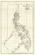
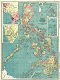
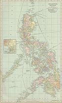
Home  |  Help  |  Graphics Tutorial  |  Aerial Photography  |  Historical Maps  |  Contemporary Maps  |  About this site  | 


.


  Main Author:   Bellin, Jacques Nicolas
  Title/Description:   Carte des Isles Philippines
  Publication Info:   Paris: 1752
  Date:   1752
  Scale:   1:4,500,000
  Original Source:   Courtesy of Murray Hudson, Halls, Tennessee
Viewing options:


  Main Author:   Bellin, Jacques Nicolas (info)
  Title/Description:   Carte des Iles Philippines
  Publication Info:   Paris: J.N. Bellin, 1752; from A.F. Prevost's Histoire Generale Des Voyages, Tome X Page 377
  Date:   1752
  Scale:   1:4,403,520
  Original Source:   Courtesy of Antique Atlas
Viewing options:


  Main Author:   Weller, Edward
  Title/Description:   Borneo, The Philippine Islands
  Publication Info:   London: Cassell, Peter and Galpin c.1862; from The Complete Atlas
  Date:   1862
  Scale:   1:5,702,400
  Original Source:   Courtesy of Murray Hudson, Halls, Tennessee
Viewing options:


  Main Author:   Casariego, Enrique Abella
  Title/Description:   Isla de Panay Bosquejo Geologico (North Sheet)
  Publication Info:   Manila: Carmelo and Bauermann, 1890
  Date:   1891
  Scale:   1:200,000
  Original Source:   Amelia Gayle Gorgas Library
Viewing options:


  Main Author:   Casariego, Enrique Abella
  Title/Description:   Isla de Panay Bosquejo Geologico (South Sheet)
  Publication Info:   Manila: Carmelo and Bauermann, 1890
  Date:   1891
  Scale:   1:200,000
  Original Source:   Amelia Gayle Gorgas Library
Viewing options:


  Main Author:   Mast, Crowell and Kirkpatrick
  Title/Description:   Map of Philippine Islands
  Publication Info:   New York: Mast, Crowell and Kirkpatrick, 1891
  Date:   1891
  Scale:   1:5,386,000
  Original Source:   Courtesy of Murray Hudson, Halls, Tennessee
Viewing options:


  Main Author:   Rand McNally and Company
  Title/Description:   Philippine Islands
  Publication Info:   Chicago: Rand McNally and Company, 1898
  Date:   1898
  Scale:   1:6,970,000
  Original Source:   Courtesy of Murray Hudson, Halls, Tennessee
Viewing options:


  Main Author:   Mast, Crowell and Kirkpatrick
  Title/Description:   Map of Philippine Islands
  Publication Info:   Philadelphia: Mast, Crowell and Kirkpatrick, 1898; from The Peerless Atlas of the World
  Date:   1898
  Scale:   1:5,385,600
  Original Source:   University of Alabama Map Library
Viewing options:


  Main Author:   Rand McNally and Company
  Title/Description:   Philippine Islands
  Publication Info:   Chicago: Rand McNally and Company, 1898; from The Indexed Atlas of the World
  Date:   1898
  Scale:   1:6,969,600
  Original Source:   Courtesy of Murray Hudson, Halls, Tennessee
Viewing options:


  Main Author:   Cram, George F.
  Title/Description:   Philippine Islands
  Publication Info:   Chicago: George F. Cram, 1899
  Date:   1899
  Scale:   1:2,850,000
  Original Source:   Courtesy of Murray Hudson, Halls, Tennessee
Viewing options:


  Main Author:    
  Title/Description:   Philippine Islands
  Publication Info:   Chicago: J. Martin Miller, 1899
  Date:   1899
  Scale:   1:4,750,000
  Original Source:   Courtesy of Murray Hudson, Halls, Tennessee
Viewing options:


  Main Author:    
  Title/Description:   Luzon, Philippine Islands
  Publication Info:   Chicago: J. Martin Miller, 1899
  Date:   1899
  Scale:   1:1,584,000
  Original Source:   Courtesy of Murray Hudson, Halls, Tennessee
Viewing options:


  Main Author:   Rand McNally and Company
  Title/Description:   Island of Luzon, Philippine Islands
  Publication Info:   Chicago: Rand McNally and Company, 1899
  Date:   1899
  Scale:   1:2,408,000
  Original Source:   Courtesy of Murray Hudson, Halls, Tennessee
Viewing options:


  Main Author:   
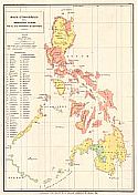
Blumentritt, Ferdinand
  Title/Description:   
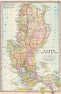
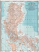
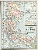
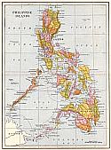
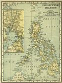
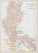
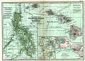
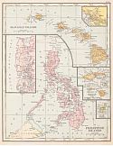
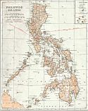
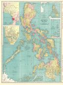
Mapa Etnografico del Archipielago Filipino
  Publication Info:   Washington, DC: Smithsonian Institution, Bureau of Ethnology, 1899; Smithsonian Report, Plat I; reproduced from Boletin de La Sociedad Geografica de Madrid, 1890
  Date:   1899
  Scale:   1:3,000,000
  Original Source:   Courtesy of Murray Hudson, Halls, Tennessee
Viewing options:


  Main Author:   Cram, George F.
  Title/Description:   Island of Luzon
  Publication Info:   Chicago: George F. Cram, c. 1899
  Date:   1899
  Scale:   1:1,901,000
  Original Source:   Courtesy of Murray Hudson, Halls, Tennessee
Viewing options:


  Main Author:   Smith, Benjamin E.
  Title/Description:   Philippine Islands and Hawaii
  Publication Info:   New York: The Century Company, 1899; from The Century Atlas of the World
  Date:   1899
  Scale:   1:2,280,960
  Original Source:   University of Alabama Map Library
Viewing options:


  Main Author:   Ourand, C.H. and D.H. Blakelock
  Title/Description:   Theatre of Military Operations in Luzon, 1899
  Publication Info:   Washington: War Department, Military Information Division, 1899; from Supplement to Vol. X of the National Geographic Magazine
  Date:   1899
  Scale:   1:190,080
  Original Source:   Geological Survey of Alabama
Viewing options:


  Main Author:   Meissas, Achille et Auguste Michelot
  Title/Description:   Philippine Islands
  Publication Info:   New York: The Bradstreet Company, 1899; from Bradstreet's Pocket Atlas of the United States
  Date:   1899
  Scale:   1:13,940,000
  Original Source:   University of Alabama Map Library
Viewing options:


  Main Author:   Servoss, R.D.
  Title/Description:   Philippine Islands
  Publication Info:   New York: The Snow-Church Surety Company, 1900; from The Legal and Banking Year Book
  Date:   1900
  Scale:   1:6,970,000
  Original Source:   Courtesy of Murray Hudson, Halls, Tennessee
Viewing options:


  Main Author:    
  Title/Description:   Mindanao Distribution of Races
  Publication Info:   Washington: Department of War, 1900; from 56th Congress, 2nd Session
  Date:   1900
  Scale:   1:2,096,914
  Original Source:   Courtesy of Murray Hudson, Halls, Tennessee
Viewing options:


  Main Author:    
  Title/Description:   Route Sketch of Line Advance of General Lawton's Division From San Pedro Macati to Los Pinas
  Publication Info:   Washington: Department of War, 1900; from 56th Congress, 2nd Session
  Date:   1900
  Scale:   1:24,369
  Original Source:   Courtesy of Murray Hudson, Halls, Tennessee
Viewing options:


  Main Author:    
  Title/Description:   Plan of Santa Cruz
  Publication Info:   Washington: Department of War, 1900; from 56th Congress, 2nd Session
  Date:   1900
  Scale:   1:3,840
  Original Source:   Courtesy of Murray Hudson, Halls, Tennessee
Viewing options:


  Main Author:    
  Title/Description:   Sketch of Position at Majayjay
  Publication Info:   Washington: Department of War, 1900; from 56th Congress, 2nd Session
  Date:   1900
  Scale:   1:8,450
  Original Source:   Courtesy of Murray Hudson, Halls, Tennessee
Viewing options:


  Main Author:    
  Title/Description:   Plan of Bixan
  Publication Info:   Washington: Department of War, 1900; from 56th Congress, 2nd Session
  Date:   1900
  Scale:   1:1,920
  Original Source:   Courtesy of Murray Hudson, Halls, Tennessee
Viewing options:


  Main Author:   Siebert, W.L.
  Title/Description:   Map Showing Theatre of Operations
  Publication Info:   Washington: Department of War, 1900; from 56th Congress, 2nd Session
  Date:   1900
  Scale:   1:211,200
  Original Source:   Courtesy of Murray Hudson, Halls, Tennessee
Viewing options:


  Main Author:   Smith, Guy H.B.
  Title/Description:   Map of Portion Zopote River and Vicinity, Scene of Operations of General's Lawton's Division, June 13th, 1899
  Publication Info:   Washington: Department of War, 1900; from 56th Congress, 2nd Session
  Date:   1900
  Scale:   1:6,300
  Original Source:   Courtesy of Murray Hudson, Halls, Tennessee
Viewing options:


  Main Author:   P. Jose Algua
  Title/Description:   Atlas of the Philippine Islands
  Publication Info:   Washington: U.S. Coast and Geodetic Survey, 1900
  Date:   1900
  Scale:   1:Various
  Original Source:   University of Alabama Map Library
Viewing options:


  Main Author:   Rand McNally and Company
  Title/Description:   Phillippine Islands
  Publication Info:   Chicago: Rand McNally and Company, 1901; from The Enlarged Business Atlas and Shippers Guide
  Date:   1901
  Scale:   1:6,969,600
  Original Source:   Courtesy of Murray Hudson, Halls, Tennessee
Viewing options:


  Main Author:   Tunison, Henry Cuthbert
  Title/Description:   Philippine Islands
  Publication Info:   New York: H.C. Tunison, 1901; from Tunison's Atlas, Encyclopædia, Gazetteer, and Portfolio of Our Universe, Globe, and Nation
  Date:   1901
  Scale:   1:2,787,840
  Original Source:   University of Alabama Map Library
Viewing options:


  Main Author:   Signal Corps, U.S. Army
  Title/Description:   Progress Map of Signal Corps Telegraph Lines and Cables in the Military Division of the Philippines, Sheet 1
  Publication Info:   Washington: National Geographic Magazine, 1902
  Date:   1902
  Scale:   1:887,040
  Original Source:   Geological Survey of Alabama
Viewing options:


  Main Author:   Signal Corps, U.S. Army
  Title/Description:   Progress Map of Signal Corps Telegraph Lines and Cables in the Military Division of the Philippines, Sheet 2
  Publication Info:   Washington: National Geographic Magazine, 1902
  Date:   1902
  Scale:   1:887,040
  Original Source:   Geological Survey of Alabama
Viewing options:


  Main Author:   Mast, Crowell and Kirkpatrick
  Title/Description:   Philippine Islands
  Publication Info:   Springfield, OH: The Crowell Publishing Company, 1904
  Date:   1904
  Scale:   1:4,562,000
  Original Source:   Courtesy of Murray Hudson, Halls, Tennessee
Viewing options:


  Main Author:   Rand McNally and Company
  Title/Description:   Philippine Islands
  Publication Info:   Chicago: Rand McNally and Company, 1905; from The Enlarged Business Atlas and Shippers Guide
  Date:   1905
  Scale:   1:2,280,960
  Original Source:   Courtesy of Murray Hudson, Halls, Tennessee
Viewing options:


  Main Author:   Rand McNally and Company
  Title/Description:   Philippine Islands
  Publication Info:   Chicago: Rand McNally and Company, 1905; from Indexed Atlas of the World
  Date:   1905
  Scale:   1:2,280,960
  Original Source:   University of Alabama Map Library
Viewing options:


  Main Author:   War Department, Bureau of Insular Affairs
  Title/Description:   Map of the Philippines
  Publication Info:   Washington: National Geographic Society, 1905
  Date:   1905
  Scale:   1:2,407,680
  Original Source:   Geological Survey of Alabama
Viewing options:


  Main Author:    
  Title/Description:   Philippine Islands
  Publication Info:   Chicago: George F. Cram for A.A. Grant, Toronto, Ontario 1906; from Grant's Bankers and Brokers Railroad System Atlas
  Date:   1906
  Scale:   1:2,724,480
  Original Source:   Courtesy of Murray Hudson, Halls, Tennessee
Viewing options:


  Main Author:   Cram, George F.
  Title/Description:   Philippine Islands
  Publication Info:   Chicago: George F. Cram, 1907; from The Standard American Atlas
  Date:   1907
  Scale:   1:4,561,920
  Original Source:   University of Alabama Map Library
Viewing options:


  Main Author:   Hammond, C.S.
  Title/Description:   Philippine Islands
  Publication Info:   New York: C.S. Hammond & Co., 1908; from Hammond's Handy Atlas of the World
  Date:   1908
  Scale:   1:9,051,430
  Original Source:   Courtesy of Murray Hudson, Halls, Tennessee
Viewing options:


  Main Author:   Rand McNally and Company
  Title/Description:   Luzon Islands
  Publication Info:   Chicago, Rand McNally and Company, 1908; from The New Ideal State and County Survey and Atlas
  Date:   1908
  Scale:   1:2,280,960
  Original Source:   University of Alabama Map Library
Viewing options:


  Main Author:   Patten, William and J.E. Homas
  Title/Description:   Philippine Islands
  Publication Info:   New York: P.F. Collier and Son, 1909; from The New Encyclopedic Atlas and Gazetteer of the World
  Date:   1909
  Scale:   1:6,019,200
  Original Source:   University of Alabama Map Library
Viewing options:
 

  Main Author:   Cram, George F.
  Title/Description:   Phillippine Islands
  Publication Info:   Chicago: George F. Cram, 1909; from The Art of Our Country
  Date:   1909
  Scale:   1:4,752,000
  Original Source:   Courtesy of Murray Hudson, Halls, Tennessee
Viewing options:


  Main Author:   Carmelite House
  Title/Description:   The Philippine Islands
  Publication Info:   London: Carmelite House, c.1910; from The Harmsworth Atlas and Gazetteer
  Date:   1910
  Scale:   1:8,900,000
  Original Source:   University of Alabama Map Library
Viewing options:


  Main Author:   Hammond, C.S.
  Title/Description:   Philippine Islands
  Publication Info:   New York: C.S. Hammond and Company, 1911; from The Modern Atlas of the World
  Date:   1911
  Scale:   1:6,019,200
  Original Source:   Courtesy of Murray Hudson, Halls, Tennessee
Viewing options:


  Main Author:   Ravenstein, E.G.
  Title/Description:   Philippine Islands
  Publication Info:   Chicago: The Reilly and Britton Company, 1911; from The New Census Atlas of the World
  Date:   1911
  Scale:   1:5,700,000
  Original Source:   University of Alabama Map Library
Viewing options:


  Main Author:   Rand McNally and Company
  Title/Description:   Philippine Islands
  Publication Info:   Chicago: Rand McNally and Company, 1912
  Date:   1912
  Scale:   1:4,752,000
  Original Source:   Courtesy of Murray Hudson, Halls, Tennessee
Viewing options:


  Main Author:   Rand McNally and Company
  Title/Description:   Luzon Island
  Publication Info:   Chicago: Rand McNally and Company; from The Rand McNally Imperial Atlas of the World
  Date:   1912
  Scale:   1:2,280,960
  Original Source:   Courtesy of Murray Hudson, Halls, Tennessee
Viewing options:


  Main Author:   The Century Company
  Title/Description:   Philippine Islands and Hawaii
  Publication Info:   New York: The Century Company, 1913; from The Century Atlas of the World
  Date:   1913
  Scale:   1:2,280,960
  Original Source:   University of Alabama Map Library
Viewing options:


  Main Author:   Redway, Jacques W. and Russell Hinman
  Title/Description:   Philippine Islands and Hawaii
  Publication Info:   New York: American Book Company, 1913; from Natural School Geography
  Date:   1913
  Scale:   1:9,504,000
  Original Source:   Courtesy of Murray Hudson, Halls, Tennessee
Viewing options:


  Main Author:   Reynolds, Francis J.
  Title/Description:   Phillipine Island
  Publication Info:   New York: P.F.Collier and Son, 1914; from the Encyclopedic Atlas and Gazetteer of the World
  Date:   1914
  Scale:   1:6,019,200
  Original Source:   Courtesy of Murray Hudson, Halls, Tennessee
Viewing options:


  Main Author:   Rand McNally and Company
  Title/Description:   Philippine Islands
  Publication Info:   Chicago: Rand McNally and Company, 1914; from Atlas of Foreign Countries
  Date:   1914
  Scale:   1:2,280,960
  Original Source:   University of Alabama Map Library
Viewing options:


  Main Author:   Rand McNally and Company
  Title/Description:   Philippine Islands
  Publication Info:   Chicago: Rand McNally and Company, 1915; from The Ideal Atlas of the World
  Date:   1915
  Scale:   1:4,752,000
  Original Source:   University of Alabama Map Library
Viewing options:


  Main Author:   Hammond, C.S.
  Title/Description:   Philippine Islands
  Publication Info:   New York: C.S. Hammond and Company, 1917; from The New Universal Atlas of the World
  Date:   1917
  Scale:   1:6,019,200
  Original Source:   Courtesy of Murray Hudson, Halls, Tennessee
Viewing options:


  Main Author:   Reynolds, Francis J.
  Title/Description:   Philippine Islands
  Publication Info:   New York: P.F. Collier and Son Company, 1920; from The New World Atlas and Gazetteer
  Date:   1920
  Scale:   1:7,413,120
  Original Source:   Courtesy of Murray Hudson, Halls, Tennessee
Viewing options:


  Main Author:   Cram, George F.
  Title/Description:   Phillipine Islands
  Publication Info:   Chicago: James R. Gray and Company, 1920; from Cram's Unrivaled Atlas of the World
  Date:   1920
  Scale:   1:4,561,920
  Original Source:   Courtesy of Murray Hudson, Halls, Tennessee
Viewing options:


  Main Author:   Rand McNally and Company
  Title/Description:   Philippine Islands
  Publication Info:   Chicago: Rand McNally and Company, 1921
  Date:   1921
  Scale:   1:2,280,960
  Original Source:   University of Alabama Map Library
Viewing options:


  Main Author:   C.S. Hammond and Company
  Title/Description:   Philippine Islands
  Publication Info:   New York: C.S. Hammond and Company, 1922; from the New World Loose Leaf Atlas
  Date:   1922
  Scale:   1:2,027,520
  Original Source:   Courtesy of Murray Hudson, Halls, Tennessee
Viewing options:


  Main Author:   Cram, George F.
  Title/Description:   Island of Luzon
  Publication Info:   Chicago: George F. Cram Company, 1923; from Cram's Unrivaled Atlas of the World
  Date:   1923
  Scale:   1:1,900,000
  Original Source:   University of Alabama Map Library
Viewing options:


  Main Author:   Cram, George F.
  Title/Description:   Philippine Islands
  Publication Info:   Chicago: George F. Cram Company, 1923; from Cram's Unrivaled Atlas of the World
  Date:   1923
  Scale:   1:4,435,200
  Original Source:   University of Alabama Map Library
Viewing options:


  Main Author:   Reynolds, Francis J.
  Title/Description:   Philippine Islands
  Publication Info:   New York: P.F. Collier and Son Company, 1924; from The New World Atlas and Gazetteer
  Date:   1924
  Scale:   1:6,019,200
  Original Source:   University of Alabama Map Library
Viewing options:


  Main Author:   Rand McNally and Company
  Title/Description:   Philippine Islands
  Publication Info:   Chicago: Rand McNally and Company, 1925; from Premier Atlas of the World
  Date:   1925
  Scale:   1:4,752,000
  Original Source:   University of Alabama Map Library
Viewing options:


  Main Author:   C.S. Hammond and Company
  Title/Description:   Philippine Islands
  Publication Info:   New York: C.S. Hammond and Company, c. 1930; from The New World Loose Leaf Atlas, Sixth Edition
  Date:   1930
  Scale:   1:3,800,000
  Original Source:   University of Alabama Map Library
Viewing options:


  Main Author:   Rand McNally and Company
  Title/Description:   Standard Map of Philippine Islands
  Publication Info:   Chicago: Rand McNally and Company, 1936
  Date:   1936
  Scale:   1:2,464,000
  Original Source:   University of Alabama Map Library
Viewing options:


  Main Author:   Geographical Publishing Company
  Title/Description:   Philippine Islands
  Publication Info:   Chicago: Geographical Publishing Company, 1942; from The New International Atlas of The World, War Edition
  Date:   1942
  Scale:   1:5,069,000
  Original Source:   University of Alabama Map Library
Viewing options:


Main Author:   Army Map Service
Title/Description:   Philippines
Publication Info:   Washington: Army Map Service, U.S. Army, 1943
Date:   1943
Scale:   1:2,000,000
Original Source:   University of Alabama Map Library
 
North
Viewing options:
 
South
Viewing options:


  Main Author:   Central Intelligence Agency
  Title/Description:   Philippines
  Publication Info:   Washington: Central Intelligence Agency, 1968
  Date:   1968
  Scale:   1:3,620,000
  Original Source:   University of Alabama Map Library
Viewing options:
 

.


© University of Alabama
To purchase map reproductions, submit a quote request.
Download MrSID Plugin