Home
|
Help
|
Graphics Tutorial
|
Aerial Photography
|
Historical Maps
|
Contemporary Maps
|
About this site
|
.
Main Author:
Bellin, Jacques Nicolas (
info
)
Title/Description:
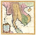
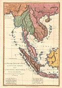
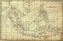
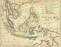
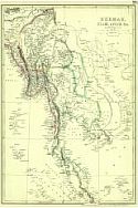
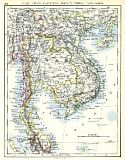
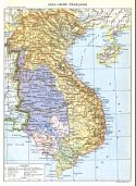
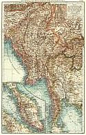
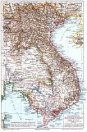
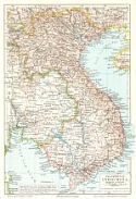
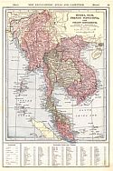
Carte Des Royaumes De Siam, De Tunquin, Pegu, Ava, Arcana, &c. (Indonesia)
Publication Info:
Paris: Chez Didot, 1751, from A.F. Prevost's
Histoire Generale Des Voyages
, Tome IX, No.8
Date:
1751
Scale:
1:8,870,000
Original Source:
Courtesy of
Murray Hudson
, Halls, Tennessee
Viewing options:
JPEG
or
Plugin
Main Author:
Bonne, Rigobert (
info
)
Title/Description:
La Presque' Isle De L' Inde Au Dela Du Gange, Avec L'Archipel Des Indes
Publication Info:
Paris: Rigobert Bonne, 1787
Date:
1787
Scale:
1:25,978,000
Original Source:
Courtesy of
Murray Hudson
, Halls, Tennessee
Viewing options:
JPEG
or
Plugin
Main Author:
Rees, Abraham
Title/Description:
Chart of the East India Islands
Publication Info:
Philadelphia: Samuel F. Bradford, 1806; from
The Cyclopaedia
Date:
1806
Scale:
1:14,142,856
Original Source:
Courtesy of
Murray Hudson
, Halls, Tennessee
Viewing options:
JPEG
or
Plugin
Main Author:
Carey, Mathew
Title/Description:
The islands of the East Indies with the Channels Between India, China and New Holland
Publication Info:
Philadelphia; Mathew Carey, 1814
Date:
1814
Scale:
1:21,860,000
Original Source:
Courtesy of
Murray Hudson
, Halls, Tennessee
Viewing options:
JPEG
or
Plugin
Main Author:
Hall, Sidney
Title/Description:
Birmah with part of Anam and Siam
Publication Info:
London: Longman, Rees, Orme, Brown and Green, 1830
Date:
1830
Scale:
1:3,294,720
Original Source:
Courtesy of
Murray Hudson
, Halls, Tennessee
Viewing options:
JPEG
or
Plugin
Main Author:
Dankworth, F.
Title/Description:
Birman Empire with Anam, Siam and Cochin China
Publication Info:
Philadelphia: Carey and Lea, 1832; from
The Family Cabinet Atlas
, First American Edition
Date:
1832
Scale:
1:27,800,000
Original Source:
Courtesy of
Murray Hudson
, Halls, Tennessee
Viewing options:
JPEG
or
Plugin
Main Author:
Black, Adam and Charles
Title/Description:
Eastern Islands, Birmah
Publication Info:
Edinburgh: A. and C. Black, 1851; from
The General Atlas
Date:
1851
Scale:
1:15,840,000
Original Source:
University of Alabama Map Library
Viewing options:
JPEG
or
Plugin
Main Author:
Black, Adam and Charles
Title/Description:
Eastern Islands, Birmah, etc.
Publication Info:
Edinburgh: A. and C. Black, 1854; from
The
General Atlas of the World
by Hall and Hughes
Date:
1854
Scale:
1:15,840,000
Original Source:
Courtesy of
Adams Antiques
, Northport, Alabama
Viewing options:
JPEG
or
Plugin
Main Author:
Weller, Edward
Title/Description:
Burmah, Siam, Anam, etc.
Publication Info:
London: Cassell, Peter and Galpin c.1862; from
The Complete Atlas
Date:
1862
Scale:
1:6,969,600
Original Source:
Courtesy of
Murray Hudson
, Halls, Tennessee
Viewing options:
JPEG
or
Plugin
Main Author:
Dower, John
Title/Description:
Map of the Proposed Route to China from British Burmah
Publication Info:
London: Illustrated London News, 1875; from the March 6, 1875 Issue
Date:
1875
Scale:
1:17,741,000
Original Source:
Courtesy of
Murray Hudson
, Halls, Tennessee
Viewing options:
JPEG
or
Plugin
Main Author:
Migeon, J.
Title/Description:
La France - Cochinchine, Cambodge, Annam and Tonkin
Publication Info:
Paris: [c. 1880]; from
Geographie Universelle
Date:
1880
Scale:
1:7,400,000
Original Source:
Courtesy of
Adams Antiques
, Northport, Alabama
Viewing options:
JPEG
or
Plugin
Main Author:
Bartholomew, John
Title/Description:
British Burmah and the Strait Settlements
Publication Info:
London: George Philip and Son, 1883; from
The Atlas of the British Empire Throughout the World
Date:
1883
Scale:
1:8,870,000
Original Source:
University of Alabama Map Library
Viewing options:
JPEG
or
Plugin
Main Author:
Blackie, Walter Graham
Title/Description:
Burmah, Siam, and Anam
Publication Info:
London: Blackie and Son, 1886; from
The Comprehensive Atlas & Geography of the World
Date:
1886
Scale:
1:7,603,200
Original Source:
University of Alabama Map Library
Viewing options:
JPEG
or
Plugin
Main Author:
Title/Description:
Indo-Chine
Publication Info:
Paris: Librerie Hachette et Cie, c. 1980; from
Atlas de Geographie Moderne
Date:
1890
Scale:
1:7,500,000
Original Source:
University of Alabama Map Library
Viewing options:
JPEG
or
Plugin
Main Author:
Bartholomew, John
Title/Description:
Farther India
Publication Info:
London: MacMillan and Company, 1890; from
The Library Reference Atlas of the World
Date:
1890
Scale:
Various
Original Source:
Courtesy of
Murray Hudson
, Halls, Tennessee
Viewing options:
JPEG
or
Plugin
Main Author:
Title/Description:
Colonies Francaises d'Asie, d'Amerique, d'Oceanie
Publication Info:
Paris: Librairie Larousse, c. 1895; from
Atlas Larousse Illustre
Date:
1895
Scale:
Various
Original Source:
University of Alabama Map Library
Viewing options:
JPEG
or
Plugin
Main Author:
Johnston, W. and A.K.
Title/Description:
Siam, Anam, Cambodia, Cochin China, Tong King
Publication Info:
Edinburgh: W. and A.K. Johnston, [c. 1897]
Date:
1897
Scale:
1:8,870,000
Original Source:
Courtesy of
Adams Antiques
, Northport, Alabama
Viewing options:
JPEG
or
Plugin
Main Author:
Johnston, W. and A.K.
Title/Description:
Burma, Ceylon, and Malay Peninsula
Publication Info:
Edinburgh: W. and A.K. Johnston, [c. 1897]
Date:
1897
Scale:
Various scales
Original Source:
Courtesy of
Adams Antiques
, Northport, Alabama
Viewing options:
JPEG
or
Plugin
Main Author:
Smith, Benjamin E.
Title/Description:
India, East including Burma, Siam, and French Indo-China
Publication Info:
New York: The Century Company, 1899; from
The Century Atlas of the World
Date:
1899
Scale:
1:6,969,600
Original Source:
University of Alabama Map Library
Viewing options:
JPEG
or
Plugin
Main Author:
The Times London
Title/Description:
Burma and the Malay Peninsula
Publication Info:
The Times London, 1899
Date:
1899
Scale:
1:6,000,000
Original Source:
University of Alabama Map Library
Viewing options:
JPEG
or
Plugin
Main Author:
Title/Description:
Indo-Chine Francaìse
Publication Info:
Paris: [c. 1901]; from
Nouveau Larousse Illustré
.
Date:
1901
Scale:
1:6,000,000
Original Source:
Courtesy of
Adams Antiques
, Northport, Alabama
Viewing options:
JPEG
or
Plugin
Main Author:
Johnston, W. and A.K.
Title/Description:
British Burma (North), Assam and Manipur
Publication Info:
Edinburgh: W and A.K. Johnston, [c. 1901]
Date:
1901
Scale:
1:3,990,000
Original Source:
Courtesy of
Adams Antiques
, Northport, Alabama
Viewing options:
JPEG
or
Plugin
Main Author:
Johnston, W. and A.K.
Title/Description:
British Burma (South) Andaman and Nicobar Islands
Publication Info:
Edinburgh: W and A.K. Johnston, [c. 1901]
Date:
1901
Scale:
1:3,990,000
Original Source:
Courtesy of
Adams Antiques
, Northport, Alabama
Viewing options:
JPEG
or
Plugin
Main Author:
The Century Company
Title/Description:
India - East, Including Burma, Siam and French Indo-China
Publication Info:
Buffalo: The Matthews-Northrup Company, 1902; from
The Century Atlas
Date:
1902
Scale:
1:6,970,000
Original Source:
From the personal collection of Dr. Robert Burckhalter
Viewing options:
JPEG
or
Plugin
Main Author:
Andrees, Richard
Title/Description:
Burma und Malayische Halbinsel
Publication Info:
Leipzig: Verlag von Velhagen and Klasing; from
Allgemeiner Handatlas
Date:
1904
Scale:
1:6,000,000
Original Source:
Courtesy of
Murray Hudson
, Halls, Tennessee
Viewing options:
JPEG
or
Plugin
Main Author:
Meyer, Joseph
Title/Description:
Französisch - Hinterindien
Publication Info:
Leipzig: Bibliographisches Institut, 1906; from
Konverlations - Lexikon
Date:
1906
Scale:
1:8,000,000
Original Source:
Courtesy of
Adams Antiques
, Northport, Alabama
Viewing options:
JPEG
or
Plugin
Main Author:
Meyer, Joseph
Title/Description:
Französisch-Indochina
Publication Info:
Leipzig: Bibliographisches Institut, 1906; from
Konverlations - Lexikon
Date:
1906
Scale:
1:8,000,000
Original Source:
Courtesy of
Adams Antiques
, Northport, Alabama
Viewing options:
JPEG
or
Plugin
Main Author:
Patten, William and J.E. Homas
Title/Description:
Burma, Siam, French Indo-China and Straits Settlements
Publication Info:
New York: P.F. Collier and Son, 1909; from
The New Encyclopedic Atlas and Gazetteer of the World
Date:
1909
Scale:
1:1,088,000
Original Source:
University of Alabama Map Library
Viewing options:
JPEG
or
Plugin
Main Author:
U.S. Navy
Title/Description:
Xuandai or Fuyen Bay and Kumong Bay (Vietnam)
Publication Info:
Washington: Hydrographic Office, U.S. Navy,1910; Chart No. 2548
Date:
1910
Scale:
1:35,000
Original Source:
University of Alabama Map Library
Viewing options:
JPEG
or
Plugin
Main Author:
The Century Company
Title/Description:
India East including Burma, Siam and French Indo-China
Publication Info:
New York: The Century Company, 1913; from
The Century Atlas of the World
Date:
1913
Scale:
1:6,969,600
Original Source:
University of Alabama Map Library
Viewing options:
JPEG
or
Plugin
Main Author:
C.S. Hammond and Company
Title/Description:
Burma, Siam and French Indo-China
Publication Info:
New York: C.S. Hammond and Company, 1918; from
Hammonds Pictorial Atlas of the World
Date:
1918
Scale:
1:10,137,600
Original Source:
University of Alabama Map Library
Viewing options:
JPEG
or
Plugin
Main Author:
Bartholomew, J.G.
Title/Description:
Farther India
Publication Info:
London: The Times, 1920; from
The Times Survey Atlas of the World
Date:
1920
Scale:
1:4,000,000
Original Source:
University of Alabama Map Library
Viewing options:
JPEG
or
Plugin
Main Author:
U.S. Navy
Title/Description:
Kamranh Bay (Vietnam)
Publication Info:
Washington: Hydrographic Office, U.S. Navy, 1921; Chart No. 2565
Date:
1921
Scale:
1:35,000
Original Source:
University of Alabama Map Library
Viewing options:
JPEG
or
Plugin
Main Author:
C.S. Hammond and Company
Title/Description:
India, East including Burma, Siam and French Indo China
Publication Info:
New York: C.S. Hammond and Company, 1922; from the
New World Loose Leaf Atlas
Date:
1922
Scale:
1:6,969,600
Original Source:
Courtesy of
Murray Hudson
, Halls, Tennessee
Viewing options:
JPEG
or
Plugin
Main Author:
U.S. Navy
Title/Description:
French Indo-China, Tonkin Gulf, Lakh Entrance to Kaotao Islands including the Delta of the Ka River
Publication Info:
Washington D.C.: Hydrographic Office, U.S. Navy, 1928; Chart No. 3160
Date:
1928
Scale:
1:234,805
Original Source:
University of Alabama Map Library
Viewing options:
JPEG
or
Plugin
Main Author:
U.S. Navy
Title/Description:
French Indo-China, Tonkin Gulf, Approaches to Port Courbet and Interior Channels between Kakba Island and Pakha Pass
Publication Info:
Washington D.C.: Hydrographic Office, U.S. Navy, 1932; Chart No. 3162
Date:
1932
Scale:
1:146,706
Original Source:
University of Alabama Map Library
Viewing options:
JPEG
or
Plugin
Main Author:
U.S. Navy
Title/Description:
French Indo-China, Tonkin Gulf, Tsieng Mun to Trako Island including the Interior Channels and Offlying Islands
Publication Info:
Washington D.C.: Hydrographic Office, U.S. Navy, 1932; Chart No. 3163
Date:
1932
Scale:
1:73,137
Original Source:
University of Alabama Map Library
Viewing options:
JPEG
or
Plugin
Main Author:
Army Map Service
Title/Description:
Indochina and Thailand Special Strategic Map
Publication Info:
Washington: U.S. Army, Army Map Service, 1945
Date:
1945
Scale:
1:3,000,000
Original Source:
University of Alabama Map Library
Viewing options:
JPEG
or
Plugin
Main Author:
Army Map Service
Title/Description:
Indochina and Thailand Special Strategic Map
Publication Info:
Washington: U.S. Army, Army Map Service, 1945
Date:
1945
Scale:
1:3,000,000
Original Source:
University of Alabama Map Library
Viewing options:
JPEG
or
Plugin
.
© University of Alabama
To purchase map reproductions, submit a
quote request
.