Viewing Options
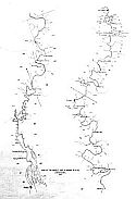
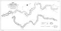
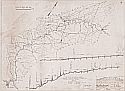
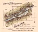
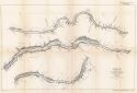
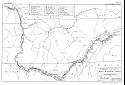
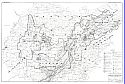
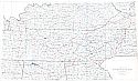
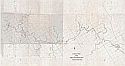
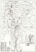
Title/Description:
Map of the Mobile and Alabama Rivers
Publication Info:
Philadelphia: Journal of the Academy of Natural Sciences, c.1899; photo copy of original map
Original Source:
Alabama Department of Archives and History

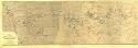
Viewing Options
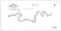
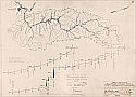
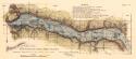
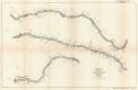
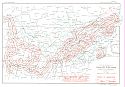
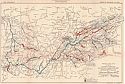
Title/Description:
Map of the Alabama River [blue print copy from original]
Publication Info:
Unknown publisher, 1920
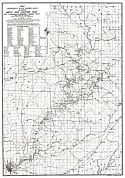
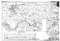
Viewing Options
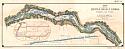
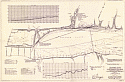
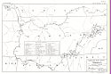
Main Author:
U.S. Army Corps of Engineers
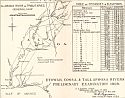
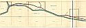
Title/Description:
Alabama River, Ala.
Publication Info:
Montgomery: U.S. Engineers Office, 1928

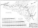
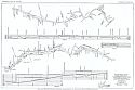
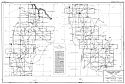
Viewing Options
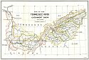
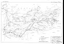
Main Author:
U.S. Army Corps of Engineers
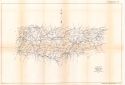
Title/Description:
Alabama - Coosa Branch of Mobile River System
Publication Info:
Washington: U.S. Army Corps of Engineers, 1941
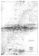
Viewing Options
Main Author:
U.S. Army Corps of Engineers
Title/Description:
Alabama - Coosa River and Tributaries
Publication Info:
Mobile: U.S. Army Corps of Engineers, c.1943
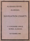
Viewing Options
Main Author:
U.S. Army Corps of Engineers
Title/Description:
Alabama River, Alabama Navigation Charts
Publication Info:
Mobile: U.S. Engineer Office, 1943
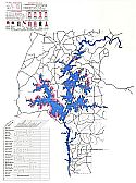
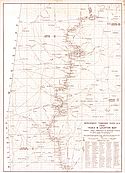
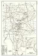
Viewing Options
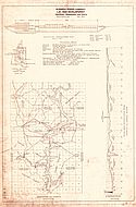
Title/Description:
Millers Ferry Reservoir Project
Publication Info:
Mobile: U.S. Army Corps of Engineers, 1962
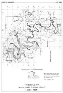
Viewing Options
Title/Description:
Jones Bluff Reservoir Project
Publication Info:
Mobile: U.S. Army Corps of Engineers, 1963

Viewing Options
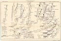
Title/Description:
Profile of the [Lower] Cahaba River, Alabama, from its mouth to Shelby County [blueprints of original]
Publication Info:
Unknown Publisher

Viewing Options
Title/Description:
Profile of the [Lower] Cahaba River, Alabama, from its mouth to Shelby County [blueprints of original]
Publication Info:
Unknown Publisher
Viewing Options
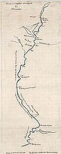
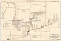
Title/Description:
A Survey of the Late Treaty West of the Chattahoochee River
Publication Info:
Hand-drawn original, c.1830
Viewing Options
Main Author:
U.S. Army Corps of Engineers
Title/Description:
Topographic Survey, Walter F. George Reservoir, Chattahoochee River
Publication Info:
Mobile: U.S. Army Corps of Engineers, 1956
Viewing Options
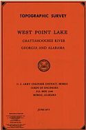
Main Author:
U.S. Army Corps of Engineers
Title/Description:
Topographic Survey, West Point Lake, Chattahoochee River, Georgia and Alabama
Publication Info:
Mobile: U.S. Army Corps of Engineers, 1975
Viewing Options
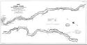
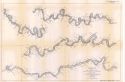
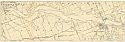
Title/Description:
Coosa River from Greensport to Wetumpka
Viewing Options
Title/Description:
Map of the Coosa River from Lock No. 4 to Greensport, Alabama
Publication Info:
Baltimore: A. Hoen and Company, [1890]; compiled under the direction of Captain Philip M. Price, Corps of Engineers to accompany the annual report of 1890
Viewing Options
Viewing Options
Viewing Options
Main Author:
Firth, Charles and H. Archibald
Title/Description:
Map of the Coosa River from Wetumpka, Alabama to Lock No. 4
Publication Info:
Montgomery: U.S. Engineer Office, 1890

Viewing Options
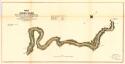
Main Author:
Cavanaugh, Capt. J.B.
Title/Description:
Topographical Map of the Coosa River, Alabama from Lock No.4 to Wetumpka
Publication Info:
Blueprint copy of original, 1903
Viewing Options
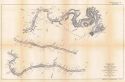
Main Author:
Unknown Author
Title/Description:
Map of Lower Coosa River, Ala., from Gadsden to Wetumpka
Publication Info:
Unknown Publisher
Viewing Options
Main Author:
Alabama Power Company
Title/Description:
Lay Dam Development
Publication Info:
Birmingham: Alabama Power Company, 1914
Viewing Options
Main Author:
U.S. Army Corps of Engineers
Title/Description:
Coosa River, Ga. and Ala.
Publication Info:
Montgomery: U.S. Engineer Office, U.S. Army Corps of Engineers, 1928
Viewing Options
Main Author:
U.S. Army Corps of Engineers, 1943
Title/Description:
Alabama-Coosa River and Tributaries: Coosa River Area
Publication Info:
Mobile: U.S. Army Corps of Engineers, 1943
Viewing Options
Main Author:
U.S. Army Corps of Engineers
Title/Description:
Tallapoosa River, GA and ALA.
Publication Info:
Montgomery: U.S. Engineer Office, U.S. Army Corps of Engineers, 1928
Viewing Options
Main Author:
Barnes, W.S.
Title/Description:
Martin Lake
Publication Info:
promotional map produced by the Tallapoosa County Probate Judge's Office
Viewing Options
Title/Description:
Muscle Shoals, Tenn. River, Little Muscle Shoals Division Sheet 3
Publication Info:
To accompany the annual report of 1882
Viewing Options
Title/Description:
Muscle Shoals, Tenn. River, Little Muscle Shoals Division Sheet 3
Publication Info:
To accompany the annual report of 1882

Viewing Options
Main Author:
Engineering Office, U.S. Army, Chattanooga, TN.
Title/Description:
Bee Tree and Colbert Shoals, Tennessee River
Publication Info:
hand drawn map from the Joseph Wheeler Family Papers, dated Dec. 16, 1886 to accompany a speech by Wheeler
Viewing Options
Main Author:
Shutting, Julius under the direction of Lt. Colonel J.W. Barlow, Corps of Engineers
Title/Description:
Map of Muscle Shoals Canal, Tennessee River
Publication Info:
Washington: Norris Peters Co., 1890
Viewing Options
Main Author:
Shutting, Rudolph Jr.
Title/Description:
Map of the Tennessee River Catchment Basin
Publication Info:
Washington: 1901
Viewing Options
Main Author:
U.S. Engineer Office
Title/Description:
Muscle Shoals Canal and Adjacent Lands
Publication Info:
Chattanooga: U.S. Engineer Office, 1905; S Doc 83 59, Map B
Viewing Options
Main Author:
U.S. Army Corps of Engineers
Title/Description:
Vicinity Map of the Tennessee River, Survey of 1909
Publication Info:
Washington: House of Representatives, 62nd, 2nd, Doc. No. 360, 1912; Plate 1
Viewing Options
Main Author:
U.S. Army Corps of Engineers
Title/Description:
Index Map of the Tennessee River Survey of the Upper Section, Head of the River to Chattanooga, 188 miles in one sheet
Publication Info:
Washington: House of Representatives, 62nd, 2nd, Doc. No. 360, 1912; Plate 2
Viewing Options
Main Author:
U.S. Army Corps of Engineers
Title/Description:
Index Map of the Tennessee River Survey of the Middle Section, Chattanooga to Riverton, 238 miles in 2 sheet, sheet 1
Publication Info:
Washington: House of Representatives, 62nd Congress, 2nd Session, Doc. No. 360, 1912; Plate 3
Viewing Options
Main Author:
U.S. Army Corps of Engineers
Title/Description:
Index Map of the Tennessee River Survey of the Middle Section, Chattanooga to Riverton, 238 miles in 2 sheets, sheet 2
Publication Info:
Washington: House of Representatives, 62nd Congress, 2nd Session, Doc. No. 360, 1912; Plate 4
Viewing Options
Main Author:
U.S. Army Corps of Engineers
Title/Description:
Index Map of the Tennessee River Survey of the Lower Section, Riverton to Paducah, 238 miles in 2 sheets, sheet 2
Publication Info:
Washington: House of Representatives, 62nd Congress, 2nd Session, Doc. No. 360, 1912; Plate 6
Viewing Options
Main Author:
U.S. Army Corps of Engineers
Title/Description:
Tennessee River, Muscle Shoals Section
Publication Info:
Washington: The Norris Peters CO., [1912]
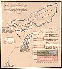
Viewing Options
Title/Description:
Map and sections showing proposed improvements of Tennessee River at Muscle Shoals
Publication Info:
Tuscaloosa: Geological Survey of Alabama, [1914]; Bulletin 17, Plate XIX
Viewing Options
Main Author:
U.S. Army Corps of Engineers
Title/Description:
Plate 62, Boat and Barge Lines
Publication Info:
Washington: Government Printing Office, 1930; from House Doc. 328, 71st Congress, 2nd Session
Viewing Options
Main Author:
U.S. Army Corps of Engineers
Title/Description:
Plate 63, Extent of Navigation
Publication Info:
Washington: Government Printing Office, 1930; from House Doc. No. 328, 71st Congress, 2nd Session
Viewing Options
Main Author:
U.S. Army Corps of Engineers
Title/Description:
Plate 64, Terminals
Publication Info:
Washington: Government Printing Office, 1930; from House Doc. No. 328, 71st Congress, 2nd Session
Viewing Options
Main Author:
U.S. Army Corps of Engineers
Title/Description:
Plate 73, Power Transmission System
Publication Info:
Washington: Government Printing Office, 1930; from House Doc. No. 328, 71st Congress, 2nd Session
Viewing Options
Main Author:
U.S. Army Corps of Engineers
Title/Description:
Mineral Resources Map
Publication Info:
Washington: Government Printing Office, 1930; from House Doc. No. 327, 71st Congress, 2nd Session
Viewing Options
Main Author:
U.S. Army Corps of Engineers
Title/Description:
Location of existing and proposed navigation, hydro-electric and reservoir projects
Publication Info:
Nashville: Department of Education, Division, 1931; from Bulletin 40
Viewing Options
Main Author:
U.S. Army Corps of Engineers
Title/Description:
Profiles of Tennessee River and its major power producing tributaries showing actual or tentative locations of navigation dams and hydro-electric power sites
Publication Info:
Nashville: Departemnt of Education, Division, 1931; from Bulletin 40
Viewing Options
Main Author:
U.S. Army Corps of Engineers
Title/Description:
Location of proposed hydro-electric power, navigation and existing projects
Publication Info:
Nashville: Department of Education, Division, 1931; from Bulletin 40
Viewing Options
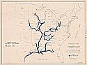
Main Author:
U.S. Geological Survey
Title/Description:
Tennessee River Basin
Publication Info:
Washington: Department of the Interior, U.S. Geological Survey, 1933
Viewing Options
Title/Description:
(Watershed of Tennessee River)
Viewing Options
Main Author:
Tennessee Valley Authority
Title/Description:
Map of Tennessee River Between Wilson Dam & Waterloo
Publication Info:
[Knoxville]: Tennessee Valley Authority, 1936

Viewing Options
Main Author:
Tennessee Valley Authority
Title/Description:
Map of Tennessee River Between Decatur & Wheeler Dam
Publication Info:
[Knoxville]: Tennessee Valley Authority, 1936

Viewing Options
Main Author:
TVA Engineering and Construction Departments
Title/Description:
Map of Guntersville Reservoir
Publication Info:
Knoxville: Tennessee Valley Authority, 1937; Guntersville Project
Viewing Options
Main Author:
U.S. Army Corps of Engineers
Title/Description:
Tennessee River and Interconnected Inland Waterway System
Publication Info:
Commerce Department, Tennessee Valley Authority, 1944; blue print copy of original
Main Author:
Tennessee Valley Authority
Title/Description:
Navigation Charts
Publication Info:
Tennessee Valley Authority, 1954-1963
Chart 001: Ohio River Pool 52, mile 0.0 to mile 15.6
Chart 101: Kentucky Reservoir and Ohio River Pool 52, mile 15.6 to mile 30.6
Chart 102: Kentucky Reservoir, mile 30.6 to mile 41.5
Chart 103: Kentucky Reservoir, mile 41.5 to mile 57.8
Chart 104: Kentucky Reservoir, mile 57.8 to mile 69.3
Chart 105: Kentucky Reservoir, mile 69.3 to mile 86.0
Chart 106: Kentucky Reservoir, mile 86.0 to mile 98.0
Chart 107: Kentucky Reservoir, mile 98.0 to mile 113.5
Chart 108: Kentucky Reservoir, mile 113.5 to mile 130.5
Chart 109: Kentucky Reservoir, mile 130.5 to mile 141.7
Chart 110: Kentucky Reservoir, mile 141.7 to mile 166.3
Chart 111: Kentucky Reservoir, mile 166.3 to mile 186.3
Chart 112: Kentucky Reservoir, mile 186.3 to mile 206.7
Chart 113: Kentucky Reservoir, mile 1.9 to mile 15.0
Chart 201: Pickwick Landing Reservoir, mile 206.7 to mile 222.7
Viewing Options
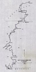
Title/Description:
Index map of the Warrior River above Tuskaloosa, Ala.
Publication Info:
Unknown, c.1850
Viewing Options
Main Author:
Smith, Eugene A.
Title/Description:
Black Warrior River from Tuscaloosa to the Fork of Sipsey and Mulberry
Publication Info:
Tuscaloosa: Geological Survey of Alabama, 1879

Viewing Options
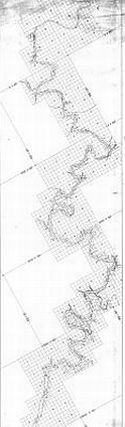
Main Author:
Hill, Louis W.
Title/Description:
1897-98 Improvement Warrior River, Alabama Index and Location Map
Publication Info:
Blueprint of original produced for the U.S. Army Corps of Engineers, 1900
Viewing Options
Main Author:
McCalla, R.C.
Title/Description:
Improvement Black Warrior River, Alabama, Index and Location Map, From Tuscaloosa to Mulberry and Locust Forks
Publication Info:
Washington: U.S. Army Corps of Engineers, 1903
Viewing Options
Main Author:
Cosby, Spencer
Title/Description:
Improvement Tombigbee River, Ala., Index and Location Map
Publication Info:
Corps of Engineers, U.S. Army, 1903; from retraced in 1951, blueprint reproduction
Viewing Options
Title/Description:
Map of the Black Warrior River to Tuscaloosa
Publication Info:
hand drawn map by an unknown author, dated 1905

Viewing Options
Title/Description:
Sipsey Fork of the Black Warrior River
Publication Info:
hand drawn map prepared by Meade and Huey, Engineers, Birminghal, AL
Viewing Options
Title/Description:
[Sipsey Fork of the Black Warrior River]
Publication Info:
hand drawn map prepared by Meade and Huey, Engineers, Birmingham, AL
Viewing Options
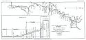
Main Author:
Hall Brothers
Title/Description:
Map and Profile of the Black Warrior River System
Publication Info:
Tuscaloosa: Geological Survey of Alabama, [1916]; Bulletin 17, Plate VI
Viewing Options
Title/Description:
Proposed Waterway to Connect the Tennessee & Tombigbee Rivers
Publication Info:
Unknown
Viewing Options
Main Author:
U.S. Army Corps of Engineers
Title/Description:
Tombigbee and Tributaries
Publication Info:
Mobile: U.S. Engineer Office, 1930
Viewing Options
Main Author:
U.S. Army Corps of Engineers
Title/Description:
Survey of the Tennessee-Tombigbee Waterway, Third Interim Report, Summit Section of Warrior - Big Spring Creek Route
Publication Info:
Mobile: U.S. Army Corps of Engineers, 1937

Viewing Options
Main Author:
U.S. Army Corps of Engineers
Title/Description:
Tennessee - Tombigbee Waterway: Warrior Route, Sheets (1-42)
Publication Info:
Mobile: U.S. Army Corps of Engineers, 1938
Viewing Options
Main Author:
U.S. Army Corps of Engineers
Title/Description:
Tennessee - Tombigbee Waterway: Tombigbee Route
Publication Info:
Mobile: U.S. Army Corps of Engineers, 1938
Viewing Options
Main Author:
U.S. Army Corps of Engineers
Title/Description:
Warrior - Tombigbee Waterway
Publication Info:
Mobile: U.S. Engineer Office, 1940
Viewing Options
Main Author:
U.S. Army Corps of Engineers
Title/Description:
Navigation Charts of Tombigbee, Warrior and Black Warrior Canalized System
Publication Info:
Mobile: U.S. Army Corps of Engineers, 1941
Viewing Options
Main Author:
Porter, W.W.
Title/Description:
Navigation Charts of Tombigbee, Warrior and Black Warrior Canalized System [Booklet of Charts]
Publication Info:
Mobile: District Office of the U.S. Army Corps of Engineers, 1954
Viewing Options
Main Author:
U.S. Army Corps of Engineers
Title/Description:
Topographic Survey, Holt Lake; Black Warrior, Alabama
Publication Info:
Mobile: District Office of the U.S. Army Corps of Engineers, 1960
Viewing Options
Main Author:
U.S. Army Corps of Engineers
Title/Description:
Navigation Charts of Tombigbee, Warrior and Black Warrior Canalized System
Publication Info:
Mobile: U.S. Army Corps of Engineers, 1941
Viewing Options
Main Author:
U.S. Army Corps of Engineers
Title/Description:
Topographic Survey, Tennessee-Tombigbee Waterway, Gainesville Lake, Tombigbee River, Alabama
Publication Info:
Mobile: U.S. Army Corps of Engineers, 1978
Viewing Options
Main Author:
U.S. Army Corps of Engineers
Title/Description:
Alabama River, Alabama, River Chart
Publication Info:
Mobile: U.S. Army Corps of Engineers, 1984