Home
|
Help
|
Graphics Tutorial
|
Aerial Photography
|
Historical Maps
|
Contemporary Maps
|
About this site
|
1750-1800
Before 1750
1750-1800
1801-1850
1851-1870
1871-1880
1881-1885
1886-1895
1896-1900
1901-1905
1906-1910
1911-1920
After 1920
Previous Page
Next Page
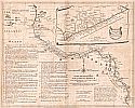
Main Author:
Postlethwayt, Malachy
Title/Description:
A New and Correct Map of the Coast of Africa
Publication Info:
London: W. Strahan and J. and F. Rivington, 1764
Date:
1764
Scale:
1:9,947,000
Original Source:
Courtesy of
Murray Hudson
, Halls, Tennessee
Viewing options:
JPEG
or
Plugin
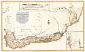
Main Author:
Sparrmans, Andrew
Title/Description:
A Geographical Chart of the Cape of Good Hope
Publication Info:
London: John Murray, 1785
Date:
1785
Scale:
1:2,778,000
Original Source:
Courtesy of
Murray Hudson
, Halls, Tennessee
Viewing options:
JPEG
or
Plugin
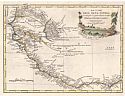
Main Author:
Carli, Presso Pazzini
Title/Description:
Le Coste Dell' Alta Guinea
Publication Info:
Siena: 1790
Date:
1790
Scale:
1:7,040,000
Original Source:
Courtesy of
Murray Hudson
, Halls, Tennessee
Viewing options:
JPEG
or
Plugin
Main Author:
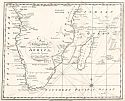
Title/Description:
A Correct Chart of the Southern Coasts of Africa, from the Equator to the Cape of Good Hope
Publication Info:
Boston: Spotswood and Nancrede, 1797; from Malham's
Naval Gazetteer
Date:
1797
Scale:
1:22,600,000
Original Source:
Courtesy of
Murray Hudson
, Halls, Tennessee
Viewing options:
JPEG
or
Plugin
Previous Page
Next Page
© University of Alabama
To purchase map reproductions, submit a
quote request
.