Next Page

  Main Author:   Bellin, Jacques Nicolas (info)
  Title/Description:   Carte De Toutes Les Isles Connues A La Coste De Zanguebar et Madagascar
  Publication Info:   Paris: Chez Didot, 1747; from A.F. Prevost's Histoire Generale Des Voyages, Tome III, No. 19
  Date:   1747
  Scale:   1:13,425,000
  Original Source:   Courtesy of Murray Hudson, Halls, Tennessee
Viewing options:


  Main Author:  

Bellin, Jacques Nicolas (info)

  Title/Description:   Carte De La Coste D'Angola
  Publication Info:   Paris: Chez Didot, 1748; from A.F. Prevost's Histoire Generale Des Voyages, Tome V, No. I
  Date:   1748
  Scale:   1:320,000
  Original Source:   Courtesy of Murray Hudson, Halls, Tennessee
Viewing options:


  Main Author:  

Bellin, Jacques Nicolas (info)

  Title/Description:   Plan Du Fort Et De La Ville Du Cap De Bonne Esperance (Cape Town)
  Publication Info:   Paris: Chez Didot, 1748; from A.F. Prevost's Histoire Generale Des Voyages, Tome V, No. 7
  Date:   1748
  Scale:   1:6,900
  Original Source:   Courtesy of Murray Hudson, Halls, Tennessee
Viewing options:


  Main Author:  

Bellin, Jacques Nicolas (info)

  Title/Description:   Carte De L'Isle D' Anjouan (Comoros)
  Publication Info:   Paris: Chez Didot, 1748; from A.F. Prevost's Histoire Generale Des Voyages, Tome V, No. 13
  Date:   1748
  Scale:   1:220,000
  Original Source:   Courtesy of Murray Hudson, Halls, Tennessee
Viewing options:


  Main Author:  

Bellin, Jacques Nicolas (info)

  Title/Description:   Carte De La Baye De La Table Et Rade Du Cap De Bonne Esperance (South Africa)
  Publication Info:   Paris: Chez Didot, 1748; from A.F. Prevost's Histoire Generale Des Voyages, Tome V, No. 6
  Date:   1748
  Scale:   1:185,000
  Original Source:   Courtesy of Murray Hudson, Halls, Tennessee
Viewing options:


  Main Author:  

Bellin, Jacques Nicolas (info)

  Title/Description:   Carte De La Baye De Mosambique
  Publication Info:   Paris: Chez Didot, 1748; from A.F. Prevost's Histoire Generale Des Voyages, Tome V, No. 8
  Date:   1748
  Scale:   1:96,000
  Original Source:   Courtesy of Murray Hudson, Halls, Tennessee
Viewing options:


  Main Author:  

Bellin, Jacques Nicolas (info)

  Title/Description:   Carte De La Baye De Sainte Helene
  Publication Info:   Paris: Chez Didot, 1749; from A.F. Prevost's Histoire Generale Des Voyages, Tome V, No. 3
  Date:   1749
  Scale:   1:435,000
  Original Source:   Courtesy of Murray Hudson, Halls, Tennessee
Viewing options:


  Main Author:  

Bellin, Jacques Nicolas (info)

  Title/Description:   Carte De La Rade De Benguella Et Riviere De Cantonbelle (Angola)
  Publication Info:   Paris: Chez Didot, 1749; from A.F. Prevost's Histoire Generale Des Voyages, Tome V, No. 2
  Date:   1749
  Scale:   1:108,000
  Original Source:   Courtesy of Murray Hudson, Halls, Tennessee
Viewing options:


  Main Author:  

Bellin, Jacques Nicolas (info)

  Title/Description:   Carte De La Baye De Saldana Ou Saldane (South America)
  Publication Info:   Paris: Chez Didot, 1749; from A.F. Prevost's Histoire Generale Des Voyages, Tome V, No. 4
  Date:   1749
  Scale:   1:210,000
  Original Source:   Courtesy of Murray Hudson, Halls, Tennessee
Viewing options:


  Main Author:   Postlethuayt, Malachy
  Title/Description:   A New and Correct Map of the Coast od Africa
  Publication Info:   London: W. Strahan & J. and F. Rivington, 1764
  Date:   1764
  Scale:   1:9,947,000
  Original Source:   Courtesy of Murray Hudson, Halls, Tennessee
Viewing options:


  Main Author:   Sparrmans, Andrew
  Title/Description:   A Geographical Chart of the Cape of Good Hope
  Publication Info:   London: John Murray, 1785
  Date:   1785
  Scale:   1:2,778,000
  Original Source:   Courtesy of Murray Hudson, Halls, Tennessee
Viewing options:


  Main Author:   Carli, Presso Pazzini
  Title/Description:   Le Coste Dell' Alta Guinea
  Publication Info:   Siena: 1790
  Date:   1790
  Scale:   1:7,040,000
  Original Source:   Courtesy of Murray Hudson, Halls, Tennessee
Viewing options:


  Main Author:    
  Title/Description:   A Correct Chart of the Southern Coasts of Africa, from the Equator to the Cape of Good Hope
  Publication Info:   Boston: Spotswood and Nancrede, 1797; Engraved for Malham's Naval Gazatteer
  Date:   1797
  Scale:   1:22,600,000
  Original Source:   Courtesy of Murray Hudson, Halls, Tennessee
Viewing options:


  Main Author:    
  Title/Description:   False Bay at the Cape of Good Hope with Soundings as Taken in the Year 1797, by Order of Rear Admiral Pringle
  Publication Info:   London: Cadell and Davis, 1803
  Date:   1803
  Scale:   1:190,000
  Original Source:   Courtesy of Murray Hudson, Halls, Tennessee
Viewing options:


  Main Author:    
  Title/Description:   Colony of the Cape of Good Hope
  Publication Info:   Boston: Arrowsmith & Lewis, 1805; from Mr. Barrow's Survey
  Date:   1805
  Scale:   1:4,245,000
  Original Source:   Courtesy of Murray Hudson, Halls, Tennessee
Viewing options:


  Main Author:   Hall, Sidney
  Title/Description:   Southern Africa
  Publication Info:   London: Longman, Rees, Orme, Brown & Green, 1829
  Date:   1829
  Scale:   1:1,584,000
  Original Source:   Courtesy of Murray Hudson, Halls, Tennessee
Viewing options:


  Main Author:    
  Title/Description:   Southern Africa
  Publication Info:   Philadelphia: Carey & Lea, 1832; from Carey & Lea's Family Cabinet Atlas, First American Edition
  Date:   1832
  Scale:   1:13,980,000
  Original Source:   Courtesy of Murray Hudson, Halls, Tennessee
Viewing options:


  Main Author:   Society for the Diffusion of Useful Knowledge
  Title/Description:   South Africa
  Publication Info:   London : Baldwin & Cradock, 1834; Compiled from the M.S. Maps in the Colonial Office, Captain Owen's Survey
  Date:   1834
  Scale:   1:4,880,000
  Original Source:   Courtesy of Murray Hudson, Halls, Tennessee
Viewing options:


  Main Author:    
  Title/Description:   Cape of Good Hope
  Publication Info:   London: Cochran & Co., 1835; for Montgomery Martin's History of the British Colonies, Volume IV
  Date:   1835
  Scale:   1:4,435,000
  Original Source:   Courtesy of Murray Hudson, Halls, Tennessee
Viewing options:


  Main Author:   Bradford, Thomas Gamaliel
  Title/Description:   Southern Africa
  Publication Info:   Boston: American Stationers Company, 1835; From a Comprehensive Atlas, Geographical, Historical, and Commercial
  Date:   1835
  Scale:   1:30,096,000
  Original Source:   Courtesy of Murray Hudson, Halls, Tennessee
Viewing options:
 

  Main Author:   Flemming, Carl
  Title/Description:   Senegambien, Sudan und Guinea
  Publication Info:   Glogau: Carle Flemming, 1841
  Date:   1841
  Scale:   1:14,927,000
  Original Source:   Courtesy of Murray Hudson, Halls, Tennessee
Viewing options:


  Main Author:   Scott, Robert
  Title/Description:   South Africa
  Publication Info:   Glasgow: Archibald Fullerton & Co., 1841; from Bell's Atlas
  Date:   1841
  Scale:   1:6,000,000
  Original Source:   Courtesy of Murray Hudson, Halls, Tennessee
Viewing options:


  Main Author:   Rapkin, John
  Title/Description:   Cape Colony
  Publication Info:   London: John Tallis & Company, c.1850
  Date:   1850
  Scale:   1:3,802,000
  Original Source:   Courtesy of Murray Hudson, Halls, Tennessee
Viewing options:


  Main Author:   Colton, Joseph Hutchins
  Title/Description:   Africa (Southern Sheet)
  Publication Info:   New York: J.H. Colton & Co., 1857
  Date:   1857
  Scale:   1:14,256,000
  Original Source:   Courtesy of Murray Hudson, Halls, Tennessee
Viewing options:


  Main Author:   Johnston, Keith
  Title/Description:   Southern Africa
  Publication Info:   Edinburgh: William Blackwood and Sons, [1861]
  Date:   1861
  Scale:   1:3,650,000
  Original Source:   University of Alabama Map Library
Viewing options:


  Main Author:   Prout, H.G.
  Title/Description:   Carte de la Route De El Obeiyas a El Facher Dressee sur Les Donnees De M. Le Commandant Prout
  Publication Info:   Cario: [Etat Major General] ,c.1877
  Date:   1877
  Scale:  

1:1,600,000

  Original Source:   Courtesy of Murray Hudson, Halls, Tennessee
Viewing options:


  Main Author:   Prout, H.G.
  Title/Description:   Expedition Prout Prounce De Kordofan
  Publication Info:   Cario: [Etat Major General] ,c.1877
  Date:   1877
  Scale:  

1:1,200,000

  Original Source:   Courtesy of Murray Hudson, Halls, Tennessee
Viewing options:


  Main Author:   Johnston, A.K.
  Title/Description:   Southern Africa Comprising Cape Colony, Natal and Orange River Free State
  Publication Info:   Edinburgh: W. and A.K. Johnston, 1878; from the Handy Royal Atlas of Modern Geography
  Date:   1878
  Scale:   1:4,245,000
  Original Source:   University of Alabama Map Library
Viewing options:


  Main Author:   Livingstone, David
  Title/Description:   A Map of a Portion of Central Africa
  Publication Info:   London: 1879; By Dr. Livingstone from His Own Survey Drawings and Observations Between the Years 1866 and 1873
  Date:   1879
  Scale:   1:2,027,000
  Original Source:   Courtesy of Murray Hudson, Halls, Tennessee
Viewing options:


  Main Author:   Bartholomew, John
  Title/Description:   South Africa
  Publication Info:   Edinburgh: A. & C. Black, 1879
  Date:   1879
  Scale:   1:3,485,000
  Original Source:   Courtesy of Murray Hudson, Halls, Tennessee
Viewing options:


  Main Author:   Stanley, Henry M.
  Title/Description:   Map Showing the Western Half of Equatorial Africa and the Explorations by Land and Water of Henry M. Stanley in the Years 1874-1877
  Publication Info:   New York: Harper & Brothers, 1879; from Through the Dark Continent or The Sources of the Nile Around the Great Lakes of Equatorial Africa and Down the Livingstone River to the Atlantic Ocean
  Date:   1879
  Scale:   1:3,168,000
  Original Source:   Courtesy of Murray Hudson, Halls, Tennessee
Viewing options:


  Main Author:   Migeon, J
  Title/Description:   La France - La Reunion, Madagascar, Gabon
  Publication Info:   Paris: 1881; from La France et ses Colonies
  Date:   1881
  Scale:   Various scales
  Original Source:   Courtesy of Adams Antiques, Northport, Alabama
Viewing options:


  Main Author:    
  Title/Description:   Southern Africa
  Publication Info:   Chicago: Rand McNally and Co., 1884; from Rand McNally Indexed Atlas of the World
  Date:   1884
  Scale:   1:5,700,000
  Original Source:   From the personal collection of Dr. Gerald Webster
Viewing options:


  Main Author:    
  Title/Description:   
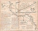
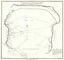
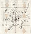
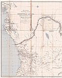
Facislmile of a Map Drawn by General Gordon, of His Route, in 1874, from Suakin to Berber and Khartum
  Publication Info:   New York: Sceince, 1885; from the April 10, 1885 Issue
  Date:   1885
  Scale:   1:1,325,000
  Original Source:   Courtesy of Murray Hudson, Halls, Tennessee
Viewing options:


  Main Author:   Tunison, Henry Cuthbert
  Title/Description:   South Africa
  Publication Info:   Jacksonville, IL: H.C. Tunison, 1885
  Date:   1885
  Scale:   1:3,800,000
  Original Source:   Courtesy of Murray Hudson, Halls, Tennessee
Viewing options:
 

  Main Author:   Peoples Publishing Company
  Title/Description:   South Africa
  Publication Info:   Chicago: Peoples Publishing Co., 1889; from Peoples Family Atlas of the World
  Date:   1889
  Scale:   1:7,920,000
  Original Source:   University of Alabama Map Library
Viewing options:


  Main Author:   Cram, George F.
  Title/Description:   South Africa
  Publication Info:   Chicago: George F. Cram, 1889
  Date:   1889
  Scale:   1:7,600,000
  Original Source:   University of Alabama Map Library
Viewing options:
 

Next Page


© University of Alabama
To purchase map reproductions, submit a quote request.
Download MrSID Plugin