Home  |  Help  |  Graphics Tutorial  |  Aerial Photography  |  Historical Maps  |  Contemporary Maps  |  About this site  | 

Historical Maps from the Civil War

 
Next Page

  Main Author:   Nicholls, Sutton
  Title/Description:   A New Map Shewing all the Severall Countries, Cities, Towns and Other Places Mentioned in the New Testament
  Publication Info:   London: Sutton Nicholls, 1700
  Date:   1700
  Scale:   various
  Original Source:   Courtesy of Murray Hudson, Halls, Tennessee
Viewing options:


  Main Author:   de Fer, Nicholas (info)
  Title/Description:   La Terra Sainte
  Publication Info:   Paris: 1705; from L' Atlas Curieux
  Date:   1705
  Scale:    
  Original Source:   Antique Atlas
Viewing options:


  Main Author:    
  Title/Description:   [Judeaea]
  Publication Info:   Paris: c.1764
  Date:   1764
  Scale:   1:400,000
  Original Source:   Antique Atlas
Viewing options:


  Main Author:   D'Anville, Jean-Baptiste B. (info)
  Title/Description:   La Palestine
  Publication Info:   London: J.B.B. D'Anville, 1767
  Date:   1767
  Scale:   1:840,000
  Original Source:   Courtesy of Murray Hudson, Halls, Tennessee
Viewing options:


  Main Author:    
  Title/Description:   [New and Ancient View of Jerusalem]
  Publication Info:   Venice: Sebastian Coleti, 1769
  Date:   1769
  Scale:   oblique view
  Original Source:   Courtesy of Murray Hudson, Halls, Tennessee
Viewing options:


  Main Author:   von Kupferstich, J.G. Beck
  Title/Description:   Palestina Medii Aevi
  Publication Info:   Altenburg: Christoph Cellanius, 1773; from Cellanius' Notitia Orbis antiquii sive geographia plenoir
  Date:   1773
  Scale:   1;914,600
  Original Source:   Antique Atlas
Viewing options:


  Main Author:   Kincaid, Alexander
  Title/Description:   Palestine or the Holy Land
  Publication Info:   Edinburgh: Alexander Kincaid, 1790
  Date:   1790
  Scale:   1:2,534,400
  Original Source:   Antique Atlas
Viewing options:


  Main Author:   Kincaid, Alexander
  Title/Description:   The journeyings of our saviour Jesus Christ
  Publication Info:   Edinburgh: Alexander Kincaid, 1790
  Date:   1790
  Scale:   1:2,598,000
  Original Source:   Antique Atlas
Viewing options:


  Main Author:   Bonne, Rigobert (info)
  Title/Description:   Carte des Regions et des lieux dont il est parle dans le Nouveau Testament
  Publication Info:   Paris: Lattre and Delalain, 1791
  Date:   1791
  Scale:   1:10,200,000
  Original Source:   Courtesy of Gary Hudson
Viewing options:


  Main Author:    
  Title/Description:   The Places Recorded in the Five Books of Moses - The Eastern Countries as Mentioned by Moses
  Publication Info:   Philadelphia: Mathew Carey & Son, 1818; from The Holy Bible: Containing the Old and New Testements Together with The Apocrypha, page 46
  Date:   1818
  Scale:   1:4,750,000
  Original Source:   Courtesy of Murray Hudson, Halls, Tennessee
Viewing options:


  Main Author:   Carey, Mathew
  Title/Description:   
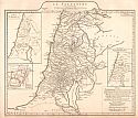
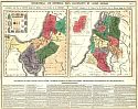
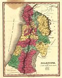
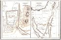
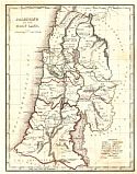
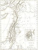
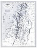
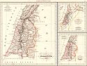
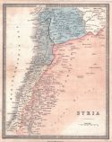
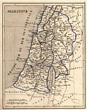
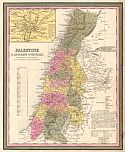
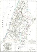
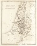
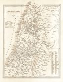
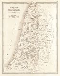
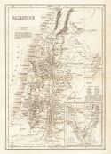
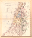
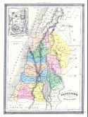
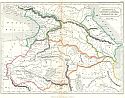
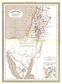
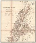
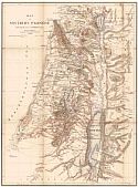
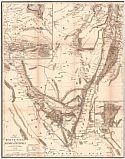
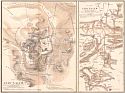
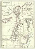
Canaan, with part of Egypt, during the Residence of the Israelites in the Desert and its Division among the Tribes
  Publication Info:   Philadelphia: M. Carey and Son, 1820; from A Complete Genelogical, Historical, Chronological and Geographical Atlas
  Date:   1820
  Scale:   various
  Original Source:   Courtesy of Murray Hudson, Halls, Tennessee
Viewing options:


  Main Author:   Finley, Anthony
  Title/Description:   The Places Recorded in the Five Books of Moses
  Publication Info:   Philadelphia: Anthony Finley, 1829; from Atlas Classica
  Date:   1829
  Scale:   1:4,752,000
  Original Source:   University of Alabama Map Library
Viewing options:


  Main Author:   Finley, Anthony
  Title/Description:   Palestine
  Publication Info:   Philadelphia: Anthony Finley, 1829; from Atlas Classica
  Date:   1829
  Scale:   1:1,140,000
  Original Source:   University of Alabama Map Library
Viewing options:


  Main Author:   Finley, Anthony
  Title/Description:   The Land of Moriah or Jerusalem
  Publication Info:   Philadelphia: Anthony Finley, 1829; from Atlas Classica
  Date:   1829
  Scale:   1:70,000
  Original Source:   University of Alabama Map Library
Viewing options:


  Main Author:   Boynton, George
  Title/Description:   Map of the Countries South of the Dead Sea & Palestine Together with the Peninsula of Mount Sinai and Part of Egypt
  Publication Info:   Boston: Crocker & Brewster, 1830; from Nathan Hale's An Epitome of Universal Geography
  Date:   1830
  Scale:   1:2,218,000
  Original Source:   Courtesy of Murray Hudson, Halls, Tennessee
Viewing options:


  Main Author:   Hall, Sidney
  Title/Description:   Palestine
  Publication Info:   London: Longman, Rees, Orme, Brown and Green, 1830
  Date:   1830
  Scale:   1:823,680
  Original Source:   Courtesy of Murray Hudson, Halls, Tennessee
Viewing options:


  Main Author:    
  Title/Description:   Jerusalem and Vicinity - Peninsula of Mt. Sinai
  Publication Info:   Boston: T.G. Bradford, 1835
  Date:   1835
  Scale:   various scales
  Original Source:   Courtesy of Murray Hudson, Halls, Tennessee
Viewing options:


  Main Author:   Bradford, Thomas G.
  Title/Description:   Palestine or the Holy Land
  Publication Info:   Boston: William D. Ticknor, 1835; from A Comprehensive Atlas Geographical, Historical, and Commercial
  Date:   1835
  Scale:   1: 1,267,200
  Original Source:   Courtesy of Murray Hudson, Halls, Tennessee
Viewing options:


  Main Author:   Davies, R.R.
  Title/Description:   Syria
  Publication Info:   London: Peter Jackson, c.1836
  Date:   1836
  Scale:   1:3,674,880
  Original Source:   Antique Atlas
Viewing options:


  Main Author:   Monin, C.V.
  Title/Description:   Palestine ou Terre Sainte
  Publication Info:   Paris: Armand Aubree, [c.1837]
  Date:   1837
  Scale:   1:950,000
  Original Source:   Courtesy of Adams Antiques, Northport, Alabama
Viewing options:


  Main Author:   Malte-Brun, Conrad
  Title/Description:   Palestine, Royanne des Israelites sous David et Solomon, & Les Douze Tribus
  Publication Info:   Paris: Aime Andre, 1837
  Date:   1837
  Scale:   Varies
  Original Source:   Antique Atlas
Viewing options:


  Main Author:    
  Title/Description:   Aegyptus et Palaestina
  Publication Info:   Gotha: Justus Perthes, 1839; from Schul-Atlas der Alten Welt
  Date:   1839
  Scale:   1:5,700,000
  Original Source:   University of Alabama Map Library
Viewing options:


  Main Author:    
  Title/Description:   Palaestina
  Publication Info:   Gotha: Justus Perthes, 1839; from Schul-Atlas der Alten Welt
  Date:   1839
  Scale:   1:3,168,000
  Original Source:   University of Alabama Map Library
Viewing options:


  Main Author:   Society for the Diffusion of Useful Knowledge
  Title/Description:   Palestine in the Time of Our Savior
  Publication Info:   London: Chapman & Hall, 1843; published under the Superintendence of the Society for the Diffusion of Useful Knowledge
  Date:   1843
  Scale:   1:760,000
  Original Source:   Courtesy of Murray Hudson, Halls, Tennessee
Viewing options:


  Main Author:   Hughes, William
  Title/Description:   The Countries Embraced within the Travels of St. Paul
  Publication Info:   Edinburgh: A&C. Black, 1843
  Date:   1843
  Scale:   1:8,554,000
  Original Source:   Courtesy of Murray Hudson, Halls, Tennessee
Viewing options:


  Main Author:   Wyld, James
  Title/Description:   Syria
  Publication Info:   London: James Wyld, 1843; from An Atlas of Modern Geography
  Date:   1843
  Scale:   1:2,850,000
  Original Source:   University of Alabama Map Library
Viewing options:


  Main Author:   Monin, C.U. and A.R. Fremin
  Title/Description:   Palestine
  Publication Info:   Paris: Armand Aubree, 1845; from Atlas Universel de Geographie Ancienne et Moderne
  Date:   1845
  Scale:   1: 1,397,499
  Original Source:   Courtesy of Murray Hudson, Halls, Tennessee
Viewing options:


  Main Author:   Mitchell, Samuel Augustus
  Title/Description:   Palestine & Adjacent Countries
  Publication Info:   Philadelphia: S.A. Mitchell, 1846
  Date:   1846
  Scale:   1:1,267,000
  Original Source:   Courtesy of Murray Hudson, Halls, Tennessee
Viewing options:


  Main Author:   Marzolla, Bendetto
  Title/Description:   Carta Della Palestina Sotto il Domino de' Romani
  Publication Info:   Naples: B. Marzolla, 1846
  Date:   1846
  Scale:   1:800,000
  Original Source:   Antique Atlas
Viewing options:


  Main Author:   Hall, Sidney
  Title/Description:   The Countries embraced within the travels of St. Paul
  Publication Info:   Edinburg: Adam and Charles Black, 1847; from Black's General Atlas
  Date:   1847
  Scale:   1: 8,554,000
  Original Source:   Courtesy of Murray Hudson, Halls, Tennessee
Viewing options:


  Main Author:   Gilbert, James
  Title/Description:   Map of Palestine or the Holy Land with Egypt and the Wilderness of Mount Sinai
  Publication Info:   London: J. Gilbert, 1849
  Date:   1849
  Scale:   1:825,000
  Original Source:   Courtesy of Murray Hudson, Halls, Tennessee
Viewing options:


  Main Author:   Jenks, William
  Title/Description:   Middle Asia
  Publication Info:   from The Explanatory Bible Atlas and Scripture Gazetteer (Fourth Edition), 1849
  Date:   1849
  Scale:   1:6,336,000
  Original Source:   University of Alabama Map Library
Viewing options:


  Main Author:   Jenks, William
  Title/Description:   Palestine or Canaan in Patriarchal Times
  Publication Info:   from The Explanatory Bible Atlas and Scripture Gazetteer (Fourth Edition), 1849
  Date:   1849
  Scale:   1:1,774,000
  Original Source:   University of Alabama Map Library
Viewing options:


  Main Author:   Jenks, William
  Title/Description:   The Holy Land Divided Among the Tribes of Israel
  Publication Info:   from The Explanatory Bible Atlas and Scripture Gazetteer (Fourth Edition), 1849
  Date:   1849
  Scale:   1:1,140,000
  Original Source:   University of Alabama Map Library
Viewing options:


  Main Author:   Jenks, William
  Title/Description:   Kingdom of David and Solomon
  Publication Info:   from The Explanatory Bible Atlas and Scripture Gazetteer (Fourth Edition), 1849
  Date:   1849
  Scale:   1:4,752,000
  Original Source:   University of Alabama Map Library
Viewing options:


  Main Author:   Jenks, William
  Title/Description:   Old World After the Flood
  Publication Info:   from The Explanatory Bible Atlas and Scripture Gazetteer (Fourth Edition), 1849
  Date:   1849
  Scale:   1:50,690,000
  Original Source:   University of Alabama Map Library
Viewing options:


  Main Author:   Jenks, William
  Title/Description:   Greece and Ionia
  Publication Info:   from The Explanatory Bible Atlas and Scripture Gazetteer (Fourth Edition), 1849
  Date:   1849
  Scale:   1:1,900,000
  Original Source:   University of Alabama Map Library
Viewing options:


  Main Author:   Jenks, William
  Title/Description:   Voyages and Travels of The Apostle Paul
  Publication Info:   from The Explanatory Bible Atlas and Scripture Gazetteer (Fourth Edition), 1849
  Date:   1849
  Scale:   1:9,500,000
  Original Source:   University of Alabama Map Library
Viewing options:


  Main Author:   Jenks, William
  Title/Description:   Kingdom of Judah and Israel
  Publication Info:   from The Explanatory Bible Atlas and Scripture Gazetteer (Fourth Edition), 1849
  Date:   1849
  Scale:   1:1,140,000
  Original Source:   University of Alabama Map Library
Viewing options:


  Main Author:   Jenks, William
  Title/Description:   Jerusalem and Its Environs
  Publication Info:   from The Explanatory Bible Atlas and Scripture Gazetteer (Fourth Edition), 1849
  Date:   1849
  Scale:   1:31,680
  Original Source:   University of Alabama Map Library
Viewing options:


  Main Author:   Jenks, William
  Title/Description:   Persia Under Darius Hystaspis
  Publication Info:   from The Explanatory Bible Atlas and Scripture Gazetteer (Fourth Edition), 1849
  Date:   1849
  Scale:   1:17,741,000
  Original Source:   University of Alabama Map Library
Viewing options:


  Main Author:   Jenks, William
  Title/Description:   Palestine
  Publication Info:   from The Explanatory Bible Atlas and Scripture Gazetteer (Fourth Edition), 1849
  Date:   1849
  Scale:   1:950,400
  Original Source:   University of Alabama Map Library
Viewing options:


  Main Author:   Findley, Alexander G.
  Title/Description:   Palaestine
  Publication Info:   New York: Harper and Brothers, 1849
  Date:   1849
  Scale:   1:1,267,000
  Original Source:   University of Alabama Map Library
Viewing options:


  Main Author:   Vuillemin, Alexandre
  Title/Description:   Palestine divisee en Tribus
  Publication Info:   Paris: [c. 1850]; from Atlas Unviersel de Geographie Ancienne et Moderne
  Date:   1850
  Scale:   1:1,250,000
  Original Source:   Courtesy of Adams Antiques, Northport, Alabama
Viewing options:


  Main Author:   Butler, Samuel
  Title/Description:   Palestine Antiqua
  Publication Info:   Philadelphia: Blanchard and Lea,1851
  Date:   1851
  Scale:   1:4,435,200
  Original Source:   Courtesy of Murray Hudson, Halls, Tennessee
Viewing options:


  Main Author:   Dufour, A.H. and T. Duvotenay
  Title/Description:   Palestina, Dividida en Tribus
  Publication Info:   Madrid: Gaspar y Roig, 1852; from El Globo, Atlas Historico Universal de Geografica
  Date:   1852
  Scale:   1:2,608,941
  Original Source:   University of Alabama Map Library
Viewing options:


  Main Author:   Black, Adam and Charles
  Title/Description:   Palestine According to it's Ancient Divisions
  Publication Info:   Edinburgh: A. and C. Black, 1854; from the General Atlas of the World by Hall and Hughes
  Date:   1854
  Scale:   1:1,014,000
  Original Source:   Courtesy of Adams Antiques, Northport, Alabama
Viewing options:


  Main Author:    
  Title/Description:   Palestine and Adjacent Countries
  Publication Info:   Philadelphia: Charles Desilver, 1856
  Date:   1856
  Scale:   1:1,200,000
  Original Source:   Courtesy of Adams Antiques, Northport, Alabama
Viewing options:


  Main Author:   Hughes, William
  Title/Description:   Palestine According to Its Ancient Divisions
  Publication Info:   Edinburgh: A. & C. Black, 1856
  Date:   1856
  Scale:   1:1,000,000
  Original Source:   Courtesy of Murray Hudson, Halls, Tennessee
Viewing options:


  Main Author:   Keipert, Heinrich
  Title/Description:   Map of Northern Palestine and Lebanon
  Publication Info:   Boston: Crocker & Brewster, 1856; drawn chiefly from the routes of Edward Robinson & Others
  Date:   1856
  Scale:   1:400,000
  Original Source:   Courtesy of Murray Hudson, Halls, Tennessee
Viewing options:


  Main Author:   Keipert, Heinrich
  Title/Description:   Map of Southern Palestine
  Publication Info:   Boston: Crocker & Brewster, 1856; drawn chiefly from the routes of Edward Robinson & Others
  Date:   1856
  Scale:   1:400,000
  Original Source:   Courtesy of Murray Hudson, Halls, Tennessee
Viewing options:


  Main Author:   Keipert, Heinrich
  Title/Description:   Map of the Peninsula of Mount Sinai and Arabia Petraea
  Publication Info:   Boston: Crocker & Brewster, 1856; from the itineraries of Edward Robinson and Eli Smith
  Date:   1856
  Scale:   1:800,000
  Original Source:   Courtesy of Murray Hudson, Halls, Tennessee
Viewing options:


  Main Author:   Keipert, Heinrich
  Title/Description:   Plan of Jerusalem - Environs of Jerusalem
  Publication Info:   Boston: Crocker & Brewster, 1856; from the routes and observations of Edward Robinson and Eli Smith
  Date:   1856
  Scale:   1:10,000
  Original Source:   Courtesy of Murray Hudson, Halls, Tennessee
Viewing options:


  Main Author:   Colton, Joseph Hutchins
  Title/Description:   Palestine
  Publication Info:   New York: J.H. Colton & Co, 1856
  Date:   1856
  Scale:   1:1,077,000
  Original Source:   Courtesy of Murray Hudson, Halls, Tennessee
Viewing options:


  Main Author:   Dussieux, Louis
  Title/Description:   La Palestine
  Publication Info:   Paris: J. Lecoffre et Comp., [1856]; from Atlas General de Geographie
  Date:   1856
  Scale:   various
  Original Source:   University of Alabama Map Library
Viewing options:


  Main Author:   Dussieux, Louis
  Title/Description:   Royaume de Jerusalem
  Publication Info:   Paris: J. Lecoffre et Comp., [1856]; from Atlas General de Geographie
  Date:   1856
  Scale:   1:3,674,880
  Original Source:   University of Alabama Map Library
Viewing options:


  Main Author:   Morse, Charles W.
  Title/Description:   Palestine
  Publication Info:   New York: Samuel N. Gaston, 1857; from Morse and Gaston's Diamond Atlas, Eastern Hemisphere
  Date:   1857
  Scale:   1:2,063,000
  Original Source:   University of Alabama Map Library
Viewing options:


  Main Author:   Andriveau-Goujon, J.
  Title/Description:   Palestine Ancienne and Moderne
  Publication Info:   Paris: J. Andriveau-Goujon, 1857; from Atlas Universel.
  Date:   1857
  Scale:   1:600,000
  Original Source:   Courtesy of Adams Antiques, Northport, Alabama
Viewing options:


  Main Author:   Society for the Diffusion of Useful Knowledge
  Title/Description:   Palestine with the Hauran and the Ancient Districts
  Publication Info:   London: Edward Stanford, 1858;published under the Superintendence of the Society for the Diffusion of Useful Knowledge
  Date:   1858
  Scale:   1:760,00
  Original Source:   Courtesy of Murray Hudson, Halls, Tennessee
Viewing options:


  Main Author:   Weller, Edward
  Title/Description:   Palestine
  Publication Info:   London: Longman and Company, c.1861
  Date:   1861
  Scale:   1:15,523,200
  Original Source:   Courtesy of Murray Hudson, Halls, Tennessee
Viewing options:


  Main Author:   Vuillemin, A and Malte-Brun
  Title/Description:   Géographie de la Bible
  Publication Info:   Paris: Frune, 1861; from Atlas Universal de Géographie Ancienne et Moderne
  Date:   1861
  Scale:   various
  Original Source:   Courtesy of Adams Antiques, Northport, Alabama
Viewing options:


Next Page.


© University of Alabama
To purchase map reproductions, submit a quote request.
Download MrSID Plugin